

View Information About HSR Ratings
Additional Information: This bridge was closed on April 4, 2019 due to deterioration. It may be at risk for replacement in the future.

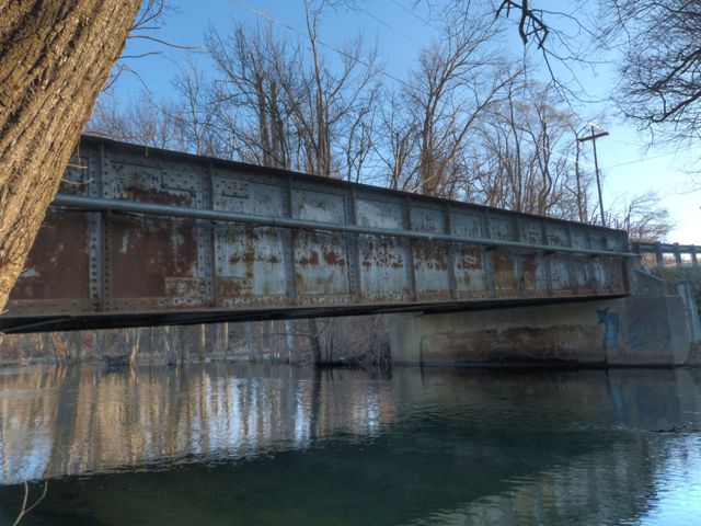
This bridge is a rare example of a through plate girder highway bridge in Michigan. This type of bridge was never common on Michigan roads. This bridge has a particularly interesting history. The construction date is listed as 1930 with a reconstruction date of 1953. However the reality is a little more complicated than the databases imply. The bridge seen today at McCabe Road was erected in 1953, reusing two salvaged riveted plate girders, apparently dating to 1930. It appears that the original floor beams and deck stringers were also salvaged and reused. Existing abutments at McCabe Road were reused, but rehabilitated and capped with new concrete. Also dating to 1953 is the heavy concrete curb that also encases the lower inside portion of the girders. The original, pre-1952 location and purpose of the two 1930 girders is unknown. The 1953 project was drawn up on 1952 plans by Foster Engineering Company of Lansing, Michigan.
The bridge today retains a 18-36-40 combination weight limit, which it has retained since at least 2004. The bridge's rural location and gravel surface makes this weight limit sufficient for the vast majority of people who would want to use the road. Unfortunately, significant section loss was observed on the girders near the top of the concrete encasement (curb) of the bridge. The concrete probably has helped to trap moisture in this area of the bridge leading to deterioration around the edges of the concrete. A possible rehabilitation option might include removing the concrete curb and patching the section loss with steel plate. Other areas of the girder appear to be in good condition.
![]()
![]()
![]()
Coordinates (Latitude, Longitude):
Search For Additional Bridge Listings:
Bridgehunter.com: View listed bridges within 0.5 miles (0.8 kilometers) of this bridge.
Bridgehunter.com: View listed bridges within 10 miles (16 kilometers) of this bridge.
Additional Maps:
Google Streetview (If Available)
GeoHack (Additional Links and Coordinates)
Apple Maps (Via DuckDuckGo Search)
Apple Maps (Apple devices only)
Android: Open Location In Your Map or GPS App
Flickr Gallery (Find Nearby Photos)
Wikimedia Commons (Find Nearby Photos)
Directions Via Sygic For Android
Directions Via Sygic For iOS and Android Dolphin Browser
USGS National Map (United States Only)
Historical USGS Topo Maps (United States Only)
Historic Aerials (United States Only)
CalTopo Maps (United States Only)

© Copyright 2003-2024, HistoricBridges.org. All Rights Reserved. Disclaimer: HistoricBridges.org is a volunteer group of private citizens. HistoricBridges.org is NOT a government agency, does not represent or work with any governmental agencies, nor is it in any way associated with any government agency or any non-profit organization. While we strive for accuracy in our factual content, HistoricBridges.org offers no guarantee of accuracy. Information is provided "as is" without warranty of any kind, either expressed or implied. Information could include technical inaccuracies or errors of omission. Opinions and commentary are the opinions of the respective HistoricBridges.org member who made them and do not necessarily represent the views of anyone else, including any outside photographers whose images may appear on the page in which the commentary appears. HistoricBridges.org does not bear any responsibility for any consequences resulting from the use of this or any other HistoricBridges.org information. Owners and users of bridges have the responsibility of correctly following all applicable laws, rules, and regulations, regardless of any HistoricBridges.org information.
![]()