

View Information About HSR Ratings
2022 Update:
According to the "Choose Marshall" Chamber of Commerce website, "Marshall, with its National Historic Landmark District status, is home to over 800 historically significant homes and buildings. The National Park Service calls Marshall "the best virtual textbook of 19th Century American architecture in the country."
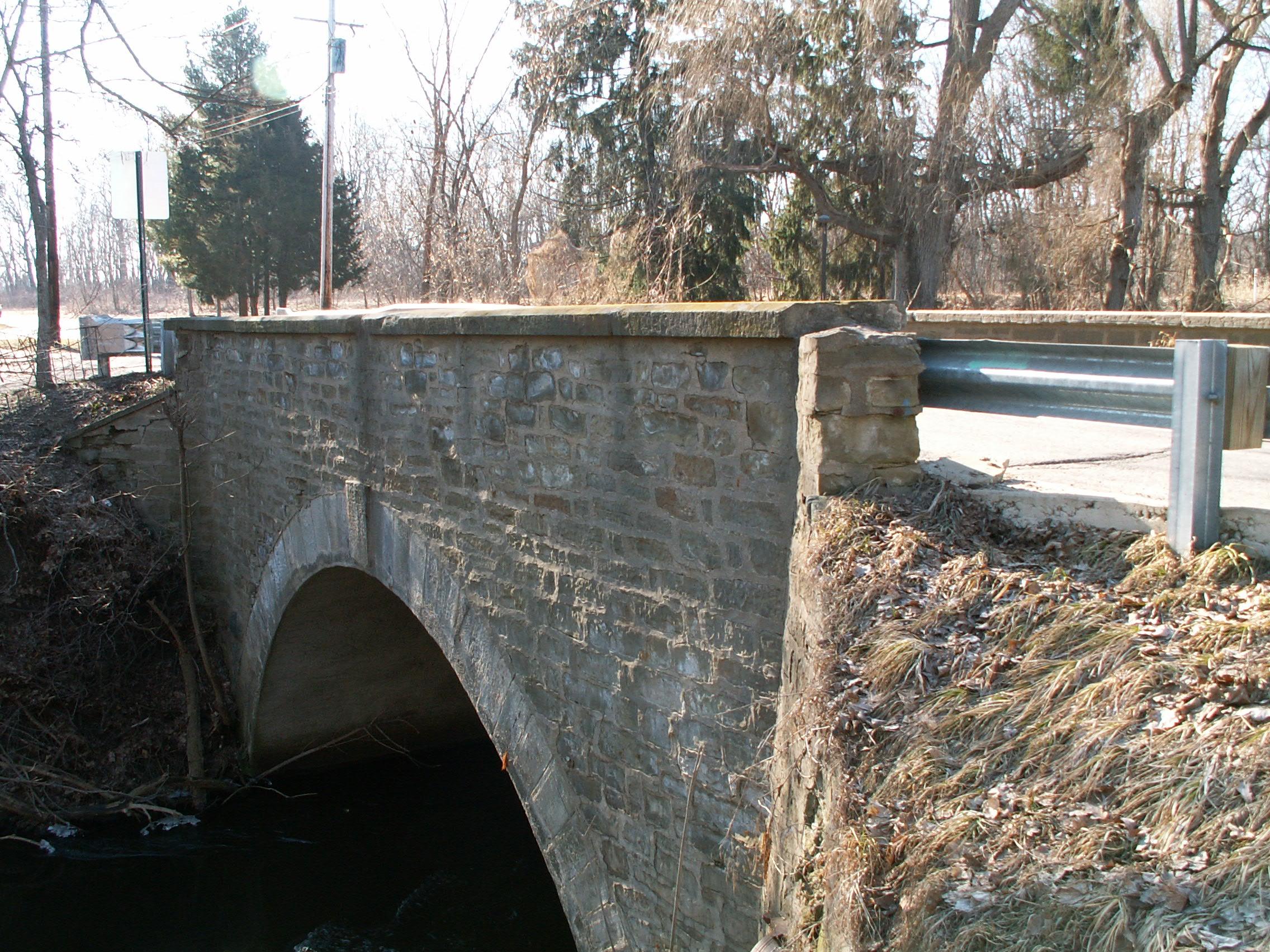
For a city that promotes itself as "historic" they sure do not give a care about their bridges! Stone arch bridges are one of the rarest bridge types in Michigan, with very few surviving examples. And here is a little fun fact... they pair well with that "19th Century American Architecture" that their Chamber promotes. The bridge here was an excellent example that could have and should have been preserved. Instead what did the city do? They demolished and replaced this bridge with a CON SPAN!!!! Con Spans are mass produced concrete structures that are prefabricated in a factory setting, ordered in standard designs, and installed. The Con Span actually pairs nicely with the equally ugly pedestrian Mail Order Bridge (MOB) next to this bridge, which is a Continental truss bridge.Con Spans are NOT fitting replacements for the craftsmanship and custom-designed details of a historic stone arch bridge. They are NOT in keeping with a community that claims to be a National Historic Landmark with a focus on 19th century Architecture. They tried to make the Con Span look like a stone arch bridge by using stone shaped formliners, but unless someone has taken leave of their senses, the only conclusion can be that the replacement bridge looks nothing like the historic bridge. Numerous alternatives would have been available to preserve this bridge, even solutions that provide for full legal loads, such as inserting a load-bearing slab inside the arch where nobody can see. A discussion of this type of preservation can be seen here.
Anyone who owns a historic house in Marshall and wants to put on a modern addition should be allowed to do so. That would be no worse than what was done here!
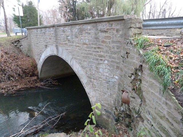
The city of Marshall has made a name for itself as having lots of historic houses. This bridge, along with the Marshall Avenue Bridge, are also significant historic attractions for the city as extremely rare examples of highway stone arch bridge construction in Michigan. A one span structure, it was constructed in 1891. The photo shown above showcases the eastern side of the bridge, which is quite beautiful. Unfortunately, the western side of the bridge has been covered with concrete, severely impacting the beauty and historic integrity of the bridge. The 1951 reconstruction date in the National Bridge Inventory likely refers to when this alteration took place. This concrete could be removed as part of a restoration, as a similar concrete removal project was done with the Marshall Avenue Bridge when it was restored. Fortunately, the keystone with date and builder name cast in was retained, and it credits Mumaw and Briege as the builders. Structurally, the bridge is in good condition, although the northeast part of the abutment has deteriorated where water is allowed to drain onto it. The bridge is posted at a 21-26-31 ton weight limit, which is enough for the residential traffic that this bridge serves.
![]()
![]()
![]()
![]()
This historic bridge has been demolished. This map is shown for reference purposes only.
Coordinates (Latitude, Longitude):
Search For Additional Bridge Listings:
Bridgehunter.com: View listed bridges within 0.5 miles (0.8 kilometers) of this bridge.
Bridgehunter.com: View listed bridges within 10 miles (16 kilometers) of this bridge.
Additional Maps:
Google Streetview (If Available)
GeoHack (Additional Links and Coordinates)
Apple Maps (Via DuckDuckGo Search)
Apple Maps (Apple devices only)
Android: Open Location In Your Map or GPS App
Flickr Gallery (Find Nearby Photos)
Wikimedia Commons (Find Nearby Photos)
Directions Via Sygic For Android
Directions Via Sygic For iOS and Android Dolphin Browser
USGS National Map (United States Only)
Historical USGS Topo Maps (United States Only)
Historic Aerials (United States Only)
CalTopo Maps (United States Only)

© Copyright 2003-2025, HistoricBridges.org. All Rights Reserved. Disclaimer: HistoricBridges.org is a volunteer group of private citizens. HistoricBridges.org is NOT a government agency, does not represent or work with any governmental agencies, nor is it in any way associated with any government agency or any non-profit organization. While we strive for accuracy in our factual content, HistoricBridges.org offers no guarantee of accuracy. Information is provided "as is" without warranty of any kind, either expressed or implied. Information could include technical inaccuracies or errors of omission. Opinions and commentary are the opinions of the respective HistoricBridges.org member who made them and do not necessarily represent the views of anyone else, including any outside photographers whose images may appear on the page in which the commentary appears. HistoricBridges.org does not bear any responsibility for any consequences resulting from the use of this or any other HistoricBridges.org information. Owners and users of bridges have the responsibility of correctly following all applicable laws, rules, and regulations, regardless of any HistoricBridges.org information.
![]()