We Recommend:
Bach Steel - Experts at historic truss bridge restoration.
BridgeHunter.com Phase 1 is released to the public! - Visit Now
Ambridge Bridge
Ambridge-Aliquippa Bridge / Ambridge-Woodlawn Bridge

Primary Photographer(s): Nathan Holth and Rick McOmber
Bridge Documented: July 3, 2006 and July 1, 2014
Ambridge and Aliquippa: Beaver County, Pennsylvania: United States
Metal Cantilever 22 Panel Multiple-Type-Connected Baltimore Through Truss, Fixed and Approach Spans: Metal 8 Panel Rivet-Connected Warren Pony Truss, Fixed
1927 By Builder/Contractor: American Bridge Company of New York, New York and Engineer/Design: T. J. Wilkerson of Beaver Falls, Pennsylvania
2013
530.0 Feet (161.5 Meters)
1,995.2 Feet (608.1 Meters)
27 Feet (8.23 Meters)
5 Main Span(s) and 5 Approach Span(s)
4740200004001

View Information About HSR Ratings
Bridge Documentation
View Archived National Bridge Inventory Report - Has Additional Details and Evaluation
View Historical Text About Woodlawn
View Historical Text About Ambridge
View Historical Text About American Bridge Company Works At Ambridge
About This Bridge
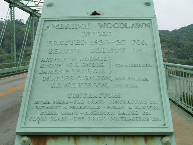
This bridge is commonly referred to as the Ambridge-Aliquippa Bridge for the two communities it runs between. However the plaque on the bridge lists the original name for the bridge, the Ambridge-Woodlawn Bridge. Woodlawn was a former town that later became part of Aliquippa.
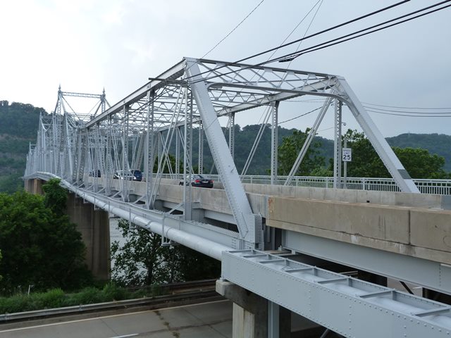
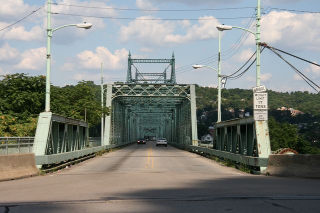
This is a rare and unique cantilever truss bridge that features both pinned and riveted connections, and is one of an extremely small number of pre-1930 cantilever truss bridges remaining nationwide. The physical appearance of the end product is unique and significant. One would be hard pressed to find another bridge that looks like this. Most cantilever bridges have only two towers/piers. See the Rochester-Monaca Railroad Bridge for an example of how a traditional cantilever bridge is configured. The Ambridge Bridge has twice as many piers, giving it a very different appearance, and making the bridge's design extremely rare. The bridge's central span includes a suspended span held by cantilever arms. The span on each side of the central span is composed of two anchor arms. The end spans of the cantilever structure are composed of cantilever arms and a rare "half-suspended span" which is held at one end by the cantilever arm with the other end resting on a pier.
This bridge is also significant as is an essential part of the heritage of Ambridge. The name of Ambridge is no coincidence. It is essentially a company town formed in 1910 by the American Bridge Company, who erected a huge factory there, hence the name AmBridge. Some of the greatest bridges in the world were fabricated in Ambridge. The towers of the Mackinac Bridge once laid in the Ambridge Yards for a test assembly. And indeed, the builder of the Ambridge Bridge superstructure the American Bridge Company. The bridge stands today as a beautiful example of why the town of Ambridge came into existence and an example of the beautiful steel bridges that it produced. The bridge is historic because of its location near a town directly associated with its builder. In other words, the bridge's setting provides it additional historic value. Ambridge has also embraced the bridge as a signature icon of the community. The Ambridge Area School District has a logo that is shaped similarly to the truss shape of the bridge. Two variations of the logo are shown below.


Bridge Rehabilitation: The Good and the Bad

From roughly 2012-2014, the Ambridge Bridge was extensively rehabilitated. Work included repair of the superstructure, and repainting of the bridge. The paint color was changed from green to grey. It should be noted that the rehabilitation of this bridge was a major victory for historic bridge preservation. The bridge had originally been slated for demolition and replacement, which is the fate of most historic bridges of this vintage in Pennsylvania. Fortunately however those plans were changed to a rehabilitation project.
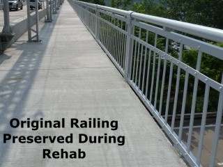
One of the positive aspects of the rehabilitation was that the original railings were not replaced with ugly modern railings, a fate that sadly befalls many of the small quantity of historic truss bridges rehabilitated in Pennsylvania.

At the same time, the rehabilitation of this bridge was not as comprehensive as it could have been. It is unclear why anyone would want to spend the money it takes to rehabilitate and repaint a bridge, yet not address all of the problems a bridge has. One of the mysteries, which has also been frustrating, for HistoricBridges.org, is why during a Section 106 Review for a historic truss bridge in Pennsylvania, does PennDOT repeatedly claim that rehabilitation is not cost-effective, alongside making claims that rehabilitation will only provide 25 additional years of service life alongside heavy maintenance costs. HistoricBridges.org knows that if engineers and fabricators experienced in truss bridge rehabilitation are involved from start to finish, a historic truss bridge can be returned to like-new condition to provide at least another 75 years of service life, with only normal maintenance and repair costs to be expected. After inspection of this bridge following rehabilitation, it appears that the reason for the 25 year claim may be that PennDOT is failing to consider a full rehabilitation that addresses all bridge problems.
With the Ambridge Bridge, there was areas of section loss, including complete section loss, that was not repaired by any of the several methods available to correct section loss. Also, while it may not have been cost-effective for the Ambridge Bridge because of its size, it is worth noting that a more complete and long-lasting paint system may be realized by disassembling a truss bridge for blasting and painting in a shop setting. Small areas of rust were already visible in 2014 on the repainted Ambridge Bridge. However, in one small area of the bridge where the new paint had been ground off apparently by the contractor, some of the old green paint was still visible. This calls into question whether the Ambridge Bridge was fully blasted. A full blasting would result in a higher quality repainting.
HistoricBridges.org is pointing these problems out not to condemn the rehabilitation of the Ambridge Bridge which saved an iconic bridge from demolition and replacement. However, it is important to note these issues if anyone wishes to fight PennDOT on its claims that rehabilitation only provides 25 years of additional service life... a claim that PennDOT has repeatedly used as an excuse to annihilate some of the finest historic bridges in the United States. The truth is that rehabilitation only provides 25 years of additional service life if its a "25 year rehabilitation" that doesn't return the bridge to like-new condition. The reality is that it is also possible to do a 75 year rehabilitation that WILL last 75 years. Don't let PennDOT try to claim otherwise.
Information and Findings From Pennsylvania's Historic Bridge InventoryDiscussion of Bridge The 1,908'-long, 8-span continuous cantilever thru truss bridge built in 1927 consists of 5 pin-connected main spans and three approach spans - an 8-panel, Warren thru truss suspended span and 2 stringer spans. The river spans consist of a 230'-long suspended span flanked by two symmetrical 150'-long cantilevered arms and 300'-long anchor spans. There are 175'-long, shore suspended spans each hung from 125'-long cantilevered arms. The bridge is supported on four concrete river piers, two concrete shore piers, three steel bents, and concrete abutments. The cantilevered sidewalk on the north side has a lattice railing. Many of the truss members including the upper chords of the anchors, some eye bars and verticals have been strengthened with additional members. The bridge was built for Beaver County, and it is a later and altered example of technology that was well known and common by the time this bridge was constructed. Its span lengths are not unusual for the bridge type/design. Neither the bridge nor its setting are historically or technologically significant. Discussion of Surrounding Area The bridge carries a two-lane street, a sidewalk, and several utilities over the Ohio River, a highway, a Conrail track and a CSXT (formerly Three Rivers Railroad) track. It serves as a link between the boroughs of Ambridge and Aliquippa. The American Bridge Co. yard is south of the bridge, and the former J & L steel mill at Aliquippa is to the north. Bridge Considered Historic By Survey: Originally Found Not Eligible for the National Register of Historic Places. This finding has later been overturned and the bridge is currently considered Eligible, making the bridge officially historic. |
![]()
Photo Galleries and Videos: Ambridge Bridge
2014 Post-Rehab Bridge Photo-Documentation
Original / Full Size PhotosA collection of overview and detail photos. This gallery offers photos in the highest available resolution and file size in a touch-friendly popup viewer.
Alternatively, Browse Without Using Viewer
![]()
2014 Post-Rehab Bridge Photo-Documentation
Mobile Optimized PhotosA collection of overview and detail photos. This gallery features data-friendly, fast-loading photos in a touch-friendly popup viewer.
Alternatively, Browse Without Using Viewer
![]()
2006-2011 Pre-Rehab Structure Overview
Original / Full Size PhotosA collection of overview photos that show the bridge as a whole and general areas of the bridge. This gallery offers photos in the highest available resolution and file size in a touch-friendly popup viewer.
Alternatively, Browse Without Using Viewer
![]()
2006-2011 Pre-Rehab Structure Details
Original / Full Size PhotosA collection of detail photos that document the parts, construction, and condition of the bridge. This gallery offers photos in the highest available resolution and file size in a touch-friendly popup viewer.
Alternatively, Browse Without Using Viewer
![]()
2006-2011 Pre-Rehab Structure Overview
Mobile Optimized PhotosA collection of overview photos that show the bridge as a whole and general areas of the bridge. This gallery features data-friendly, fast-loading photos in a touch-friendly popup viewer.
Alternatively, Browse Without Using Viewer
![]()
2006-2011 Pre-Rehab Structure Details
Mobile Optimized PhotosA collection of detail photos that document the parts, construction, and condition of the bridge. This gallery features data-friendly, fast-loading photos in a touch-friendly popup viewer.
Alternatively, Browse Without Using Viewer
![]()
CarCam: Eastbound Crossing
Full Motion VideoNote: The downloadable high quality version of this video (available on the video page) is well worth the download since it offers excellent 1080 HD detail and is vastly more impressive than the compressed streaming video. Streaming video of the bridge. Also includes a higher quality downloadable video for greater clarity or offline viewing.
![]()
Westbound Crossing
Full Motion VideoStreaming video of the bridge. Also includes a higher quality downloadable video for greater clarity or offline viewing.
![]()
Maps and Links: Ambridge Bridge
Coordinates (Latitude, Longitude):
Search For Additional Bridge Listings:
Bridgehunter.com: View listed bridges within 0.5 miles (0.8 kilometers) of this bridge.
Bridgehunter.com: View listed bridges within 10 miles (16 kilometers) of this bridge.
Additional Maps:
Google Streetview (If Available)
GeoHack (Additional Links and Coordinates)
Apple Maps (Via DuckDuckGo Search)
Apple Maps (Apple devices only)
Android: Open Location In Your Map or GPS App
Flickr Gallery (Find Nearby Photos)
Wikimedia Commons (Find Nearby Photos)
Directions Via Sygic For Android
Directions Via Sygic For iOS and Android Dolphin Browser
USGS National Map (United States Only)
Historical USGS Topo Maps (United States Only)
Historic Aerials (United States Only)
CalTopo Maps (United States Only)


