

View Information About HSR Ratings
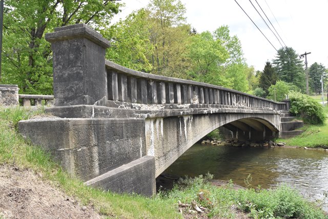
This beautifully composed bridge is one of the last remaining bridges built by a local pioneer in concrete bridge construction. It is also one of the oldest known examples of a curved t-beam bridge. Learn more about Will Dickinson on this other bridge's page.
Information and Findings From Pennsylvania's Historic Bridge InventoryDiscussion of Bridge The 1911, single span, 78'-long, reinforced concrete T beam bridge with haunched beams and concrete balustrades is supported on concrete abutments with wingwalls. The fasciae beams and the tops of the wingwalls have a bush hammered finish. The bridge is stylistically similar to two other T beam bridges designed and built by Will Dickinson in 1911-1912. He was a local engineer and contractor, who introduced reinforced concrete bridge types to Elk County beginning about 1907. The long span, haunched beam bridges are not a common early variation of the T beam bridge type, which usually was not haunched, and more often applied to span lengths of less than 50'. There are over 2,300 pre-1957 T beam highway bridges identified in the state with the earliest documented example dated to 1905, and about 30 to before 1916. It is the early examples that represent the importance and contribution of the technology to the improvement of local, county and state roads. The 1911 bridge is historically and technologically significant as an early, long, and complete example of a T beam bridge with haunched beams. Discussion of Surrounding Area The bridge carries a 2-lane road over a stream in a residential part of the village of Brockton. To the south are a house built ca. 1965 and a late 20th century modular home. To the north are an early 20th century residence with modern siding and a post-WW II house. The setting does not have historic district potential. Bridge Considered Historic By Survey: Yes |
![]()
![]()
![]()
Coordinates (Latitude, Longitude):
Search For Additional Bridge Listings:
Bridgehunter.com: View listed bridges within 0.5 miles (0.8 kilometers) of this bridge.
Bridgehunter.com: View listed bridges within 10 miles (16 kilometers) of this bridge.
Additional Maps:
Google Streetview (If Available)
GeoHack (Additional Links and Coordinates)
Apple Maps (Via DuckDuckGo Search)
Apple Maps (Apple devices only)
Android: Open Location In Your Map or GPS App
Flickr Gallery (Find Nearby Photos)
Wikimedia Commons (Find Nearby Photos)
Directions Via Sygic For Android
Directions Via Sygic For iOS and Android Dolphin Browser
USGS National Map (United States Only)
Historical USGS Topo Maps (United States Only)
Historic Aerials (United States Only)
CalTopo Maps (United States Only)

© Copyright 2003-2026, HistoricBridges.org. All Rights Reserved. Disclaimer: HistoricBridges.org is a volunteer group of private citizens. HistoricBridges.org is NOT a government agency, does not represent or work with any governmental agencies, nor is it in any way associated with any government agency or any non-profit organization. While we strive for accuracy in our factual content, HistoricBridges.org offers no guarantee of accuracy. Information is provided "as is" without warranty of any kind, either expressed or implied. Information could include technical inaccuracies or errors of omission. Opinions and commentary are the opinions of the respective HistoricBridges.org member who made them and do not necessarily represent the views of anyone else, including any outside photographers whose images may appear on the page in which the commentary appears. HistoricBridges.org does not bear any responsibility for any consequences resulting from the use of this or any other HistoricBridges.org information. Owners and users of bridges have the responsibility of correctly following all applicable laws, rules, and regulations, regardless of any HistoricBridges.org information.
![]()