

View Information About HSR Ratings
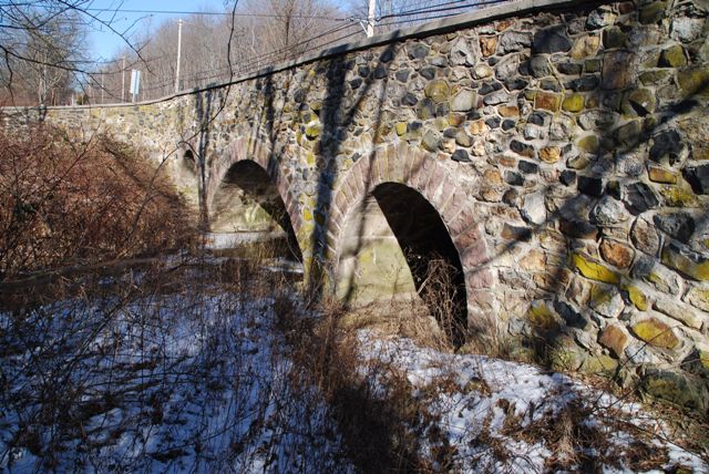
This bridge is small, but has decent historic integrity and maintains an attractive appearance.
Information and Findings From Pennsylvania's Historic Bridge InventoryDiscussion of Bridge The 3-span stone arch bridge has a 20'-long centerspan and two flanking end spans of 10'- long each. The bridge has stone parapets with replacement concrete coping. The arch rings are ashlar sandstone. It is an example of a bridge type that is common from the first two decades of the 20th century in Chester County. The county-built traditional stone arch bridges were favored by the county engineer, and at least 19 similar bridges from 1908 to 1919 have been identified. Stone arch bridges have been in use in Pennsylvania since the late 17th century, and over 350 examples have been identified statewide, with more than twothirds dating to before 1900. Early 20th century examples in Chester County are considered individually significant in the local context only when they are complete and large or particularly well detailed. This example is not historically or technologically distinguished within its population or by its setting and context. Discussion of Surrounding Area The bridge carries a 2 lane road over a stream in a rural setting with scattered 20th-century residences. South of the bridge is an electric power transmission line, and beyond that a late-20th-century residence. At the northwest quadrant is the intersection with a local road. The northeastern quadrant is wooded. The setting does not have historic district potential. Bridge Considered Historic By Survey: No Information and Findings From Pennsylvania's Stone Arch Bridge Management PlanDiscussion of Bridge This bridge is not recommended for long-term preservation. It ranks just outside of the lowest third of all stone arch bridges under study in this plan, and the bridge has a very low waterway adequacy code. Waterway adequacy is a function of the size of the arch barrel, the main structural element of the bridge. Enlarging the waterway opening generally would require the construction of a new bridge. The condition code is moderate, a result of missing stones and some scour. Its transportation code is also moderate, bordering on low, a function of high traffic volumes and narrow width. The bridge is located in an area of low development potential, and should be able to carry its traffic into the future. The cost to rehabilitate the bridge is moderate, a function of missing stones. It is not listed or eligible for listing in the National Register of Historic Places individually or as part of a historic district. This bridge has public support (one letter, six telephone calls, and one meeting at which this bridge was the focus). However, the inadequate waterway makes it difficult to recommend the bridge for long-term preservation. Ratings The West Brandywine, U.S. 30B/Indian Run Bridge is
owned by PennDOT and is ranked 84th. Recommendation: Not recommended for long-term preservation. |
![]()
![]()
![]()
Coordinates (Latitude, Longitude):
Search For Additional Bridge Listings:
Bridgehunter.com: View listed bridges within 0.5 miles (0.8 kilometers) of this bridge.
Bridgehunter.com: View listed bridges within 10 miles (16 kilometers) of this bridge.
Additional Maps:
Google Streetview (If Available)
GeoHack (Additional Links and Coordinates)
Apple Maps (Via DuckDuckGo Search)
Apple Maps (Apple devices only)
Android: Open Location In Your Map or GPS App
Flickr Gallery (Find Nearby Photos)
Wikimedia Commons (Find Nearby Photos)
Directions Via Sygic For Android
Directions Via Sygic For iOS and Android Dolphin Browser
USGS National Map (United States Only)
Historical USGS Topo Maps (United States Only)
Historic Aerials (United States Only)
CalTopo Maps (United States Only)

© Copyright 2003-2026, HistoricBridges.org. All Rights Reserved. Disclaimer: HistoricBridges.org is a volunteer group of private citizens. HistoricBridges.org is NOT a government agency, does not represent or work with any governmental agencies, nor is it in any way associated with any government agency or any non-profit organization. While we strive for accuracy in our factual content, HistoricBridges.org offers no guarantee of accuracy. Information is provided "as is" without warranty of any kind, either expressed or implied. Information could include technical inaccuracies or errors of omission. Opinions and commentary are the opinions of the respective HistoricBridges.org member who made them and do not necessarily represent the views of anyone else, including any outside photographers whose images may appear on the page in which the commentary appears. HistoricBridges.org does not bear any responsibility for any consequences resulting from the use of this or any other HistoricBridges.org information. Owners and users of bridges have the responsibility of correctly following all applicable laws, rules, and regulations, regardless of any HistoricBridges.org information.
![]()