We Recommend:
Bach Steel - Experts at historic truss bridge restoration.
BridgeHunter.com Phase 1 is released to the public! - Visit Now
Krings Bridge

Primary Photographer(s): Nathan Holth and Rick McOmber
Bridge Documented: August 2007 and July 6, 2014
Kring Street (Soap Hollow Road, PA-4041) Over Stonycreek River
Krings (Near Johnstown): Cambria County, Pennsylvania and Somerset County, Pennsylvania: United States
1937 By Builder/Contractor: Guy Trimpey and Engineer/Design: Pennsylvania State Highway Department
2007
103.0 Feet (31.4 Meters)
213.0 Feet (64.9 Meters)
23 Feet (7.01 Meters)
2 Main Span(s)
554041011029990

View Information About HSR Ratings
Bridge Documentation
View Archived National Bridge Inventory Report - Has Additional Details and Evaluation

This bridge is one of several standard plan type truss bridges that tend to date to the 1920s-1940 that are located in or just outside of Johnstown. Bridges like this one are often discarded by historic bridge inventories because they are declared undistinguished and common technology. Indeed, this was certainly the case when they were built. The fact that multiple examples of relatively similar design characteristics remain in Johnstown testifies to that fact. However, these bridges are rapidly being demolished and this is partly due to the fact that these inventories didn't even bother to consider their historic value.
Inventories should look at the fact that some of these older bridges may seem common when the inventory is taken, and then consider that even though this is the case, bridges like this are no longer being built today, and those that survive are being demolished. As such, even if the bridge is not all that rare today, it might be rare soon, and as such it should be declared historic. Perhaps the government should define a third designation for historic bridges that references bridges that are "prospectively rare and historic" meaning that as bridges are demolished, a particular bridge will then become more rare and historic. In addition, one must take into account that these bridges from this era, whether historic or not, are complex and beautiful structures that are a real asset to a city like Johnstown, and are also monuments to a city that was closely associated to the steel industry.
For a city the size of Johnstown, an unusually high number of metal truss bridges remain in the city. For this reason, these bridges should be considered part of a historic group, meaning that while an individual bridge may be of limited significance, the fact that so many are located in one city means that Johnstown is almost like a bridge museum. As such, the preservation of all metal truss bridges in Johnstown should be considered. The town already attracts tourists, particularly those interested in historic. Attractions include the Johnstown Incline Plane and the Cambria steel facilities. Creating a self-guided historic truss bridge tour might be something the city could consider in conjunction with a comprehensive preservation program that would ensure that all of the city's metal truss bridges are preserved. The city could also coordinate with the surrounding area, as a few bridges are located outside of city limits, but are still close enough to fit into this group of historic truss bridges.

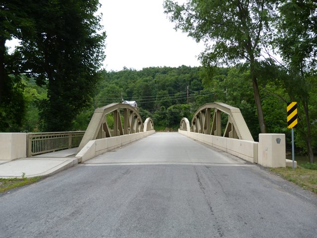
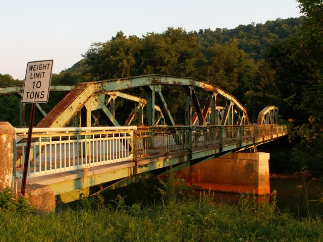
The Krings Bridge is one of two nearby multi-span pony trusses, the other being the Eisenhower Boulevard Bridge. Multi-span pony trusses are relatively uncommon to find, which makes these two bridges interesting and noteworthy.
In 2009, this bridge was rehabilitated by PennDOT, which included a new deck and repainting the trusses with a standard three coat paint system. Overall, the rehabilitation appears have been well designed, although it would have been nice if the original lattice railings could have been left in place for the sake of historic integrity behind the modern barrier system installed on the bridge. However, the sidewalk railings were retained, something which isn't always done in Pennsylvania but is extremely nice to see here. By choosing to rehabilitate this bridge, PennDOT has not only chosen to preserve an attractive historic bridge, they have also shown fiscal responsibility, since rehabilitation has traditionally been less costly than replacement. Located in PennDOT District 9, it is worth noting that District 9 has shown a slightly better track record than the rest of the PennDOT organization in terms of choosing to rehabilitate bridges instead of demolishing and replacing them. HistoricBridges.org hopes that the rehabilitation projects in District 9 will serve as inspiration elsewhere in the Commonwealth, and help to bring a positive change to the way historic bridges are treated.
Information and Findings From Pennsylvania's Historic Bridge InventoryDiscussion of Bridge The 2 simple span, 213'-long and 26' wide, Parker pony truss bridge is supported on concrete abutments with wingwalls and a concrete pier. A sidewalk with a metal railing is cantilevered from one side. The bridge is an example of a commonly used state standard design. The trusses are traditionally composed with built up box section upper chords and inclined end posts and rolled section for the web members. Although unaltered, the bridge is not a significant example of its type and design, which was common by 1910. Its setting is also not significant. Discussion of Surrounding Area The bridge carries a 2 lane street and 1 sidewalk over the Stonycreek River in Krings. At the north end of the bridge is a T intersection with Eisenhower Boulevard. At the near end of the bridge is a 1938 brick firehouse. The area is an undistinguished mix of altered late-19th and 20th century buildings. It does not have the cohesiveness or integrity to be a potential historic district. Bridge Considered Historic By Survey: No |
![]()
Photo Galleries and Videos: Krings Bridge
2007 Pre-Rehab Bridge Photo-Documentation
A collection of overview and detail photos. This photo gallery contains a combination of Original Size photos and Mobile Optimized photos in a touch-friendly popup viewer.Alternatively, Browse Without Using Viewer
![]()
2014 Post-Rehab Bridge Photo-Documentation
Original / Full Size PhotosA collection of overview and detail photos. This gallery offers photos in the highest available resolution and file size in a touch-friendly popup viewer.
Alternatively, Browse Without Using Viewer
![]()
2014 Post-Rehab Bridge Photo-Documentation
Mobile Optimized PhotosA collection of overview and detail photos. This gallery features data-friendly, fast-loading photos in a touch-friendly popup viewer.
Alternatively, Browse Without Using Viewer
![]()
Maps and Links: Krings Bridge
Coordinates (Latitude, Longitude):
Search For Additional Bridge Listings:
Bridgehunter.com: View listed bridges within 0.5 miles (0.8 kilometers) of this bridge.
Bridgehunter.com: View listed bridges within 10 miles (16 kilometers) of this bridge.
Additional Maps:
Google Streetview (If Available)
GeoHack (Additional Links and Coordinates)
Apple Maps (Via DuckDuckGo Search)
Apple Maps (Apple devices only)
Android: Open Location In Your Map or GPS App
Flickr Gallery (Find Nearby Photos)
Wikimedia Commons (Find Nearby Photos)
Directions Via Sygic For Android
Directions Via Sygic For iOS and Android Dolphin Browser
USGS National Map (United States Only)
Historical USGS Topo Maps (United States Only)
Historic Aerials (United States Only)
CalTopo Maps (United States Only)


