We Recommend:
Bach Steel - Experts at historic truss bridge restoration.
BridgeHunter.com Phase 1 is released to the public! - Visit Now
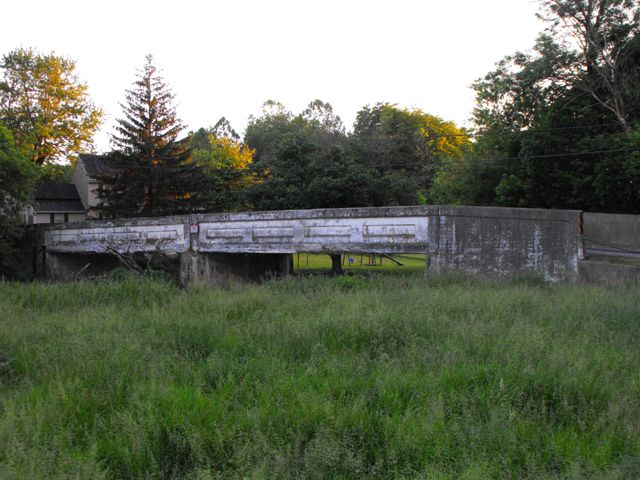
Linden Road Bridge

Primary Photographer(s): Nathan Holth and Rick McOmber
Bridge Documented: May 30, 2010
Rural: Lancaster County, Pennsylvania: United States
1914 By Builder/Contractor: Swanger-Fackler Construction Company and Engineer/Design: Frank H. Shaw of Lancaster, Pennstlvania
Not Available or Not Applicable
54.0 Feet (16.5 Meters)
109.0 Feet (33.2 Meters)
20 Feet (6.1 Meters)
2 Main Span(s)
36721309090341

View Information About HSR Ratings
Bridge Documentation
This bridge's future is at risk!
Bridge Status: This bridge is slated for demolition by Lancaster County!View Archived National Bridge Inventory Report - Has Additional Details and Evaluation
Lancaster County's engineers built a large number of concrete through girders, something most other places in Pennsylvania did not do. A noteworthy number of them remain in the county today, however many are threatened with demolition. Concrete through girders, despite their rarity, are often ignored by state historic bridge inventories and their significance often goes unrecognized. Although perhaps among the more simple and unadorned of historic bridge types, these utilitarian structures still convey a sense of age, and the simple inset rectangle shapes and marble plaques on the Lancaster County girders show that even with simple bridges like this, engineers of the early 20th Century refused to design a bridge as ugly as the slabs of concrete that pass for bridges in the 21st Century. Because concrete through girders are rare on a state level, all surviving girders in Lancaster County that retain good historic integrity should be considered significant. Concrete through girder bridges represent the period of experimentation that accompanied the use of concrete in bridge construction during the first couple decades of the 20th Century. Concrete girder bridges were in many ways a failed experiment because they could not normally be economically built with deck widths much wider than 20-22 feet, and so as the need for wider bridges became apparent moving into the 20th Century, concrete through girders quickly fell from favor, and were generally not built after 1930. Because they are rare today and represent a period of experimentation in bridge design, HistoricBridges.org considers concrete through girders to be significant.
This bridge is a good representative example of a Lancaster County through girder. Although not the earliest example in the county with a 1922 construction date, the bridge is noted for its two-span configuration. The bridge retains bronze plaques and seems to be in decent condition. The plaque mentions that the bridge was designed for a 20 ton weight limit. At the time of documentation, the bridge was posted for a 15 ton weight limit, so the bridge cannot have deteriorated too severely. Regardless, this bridge was included on a Lancaster County bridge removal list. Demolishing this bridge seems to be a waste of money. Minor repairs and maintenance would keep this bridge open for horse and buggy traffic as well as light motorized vehicles. With the light amount of traffic the bridge serves it is doubtful that the bridge will deteriorate much as long as some of the minor spalling on the bridge is arrested.
Information and Findings From Pennsylvania's Historic Bridge InventoryDiscussion of Bridge The 2 span, 109'-long reinforced concrete thru girder bridge built in 1922 is composed of two girders with an integral concrete slab deck. The paneled girders also serve as the railings. The bridge is supported on concrete pier and abutments with U-shaped wingwalls surmounted by concrete parapets. The girders and slab are spalled with exposed reinforcing bars. The bridge is an example of one of the least successful standardized reinforce concrete bridges types developed during the first decade of the 20th century. At least 65 thru girder bridges from 1906 to 1930 have been identified with more than one-third of the examples in Lancaster County where their use was forwarded by county engineer F. H. Shaw beginning before 1910. The bridge is not historically or technologically distinguished by its setting or context. Discussion of Surrounding Area The bridge carries 1 lane of a 2 lane road over a stream in a rural setting with a scattered mix of 19th to late 20th century residences and businesses. At the southern quadrants are a modern industrial building and mixing plant. At the northern quadrants are woods and a very altered late 19th century vernacular frame house. A concrete spillway is located upstream but the associated mill has been lost. The setting does not have the cohesiveness or integrity of a historic district. Bridge Considered Historic By Survey: No |
![]()
Photo Galleries and Videos: Linden Road Bridge
Bridge Photo-Documentation
Original / Full Size PhotosA collection of overview and detail photos. This gallery offers photos in the highest available resolution and file size in a touch-friendly popup viewer.
Alternatively, Browse Without Using Viewer
![]()
Bridge Photo-Documentation
Mobile Optimized PhotosA collection of overview and detail photos. This gallery features data-friendly, fast-loading photos in a touch-friendly popup viewer.
Alternatively, Browse Without Using Viewer
![]()
Maps and Links: Linden Road Bridge
Coordinates (Latitude, Longitude):
Search For Additional Bridge Listings:
Bridgehunter.com: View listed bridges within 0.5 miles (0.8 kilometers) of this bridge.
Bridgehunter.com: View listed bridges within 10 miles (16 kilometers) of this bridge.
Additional Maps:
Google Streetview (If Available)
GeoHack (Additional Links and Coordinates)
Apple Maps (Via DuckDuckGo Search)
Apple Maps (Apple devices only)
Android: Open Location In Your Map or GPS App
Flickr Gallery (Find Nearby Photos)
Wikimedia Commons (Find Nearby Photos)
Directions Via Sygic For Android
Directions Via Sygic For iOS and Android Dolphin Browser
USGS National Map (United States Only)
Historical USGS Topo Maps (United States Only)
Historic Aerials (United States Only)
CalTopo Maps (United States Only)

