We Recommend:
Bach Steel - Experts at historic truss bridge restoration.
BridgeHunter.com Phase 1 is released to the public! - Visit Now
Mill Mountain Road Bridge

Primary Photographer(s): Nathan Holth
Bridge Documented: November 16, 2010 and August 26, 2019
Rural: Luzerne County, Pennsylvania: United States
1883 By Builder/Contractor: Penn Bridge Company of Beaver Falls, Pennsylvania
1962
59.0 Feet (18 Meters)
62.0 Feet (18.9 Meters)
14.4 Feet (4.39 Meters)
1 Main Span(s)
40720403564706

View Information About HSR Ratings
Bridge Documentation
This bridge is in storage!
Bridge Status: This bridge was dismantled ca. 2020 and is slated to be reused on private property in New York State.View Archived National Bridge Inventory Report - Has Additional Details and Evaluation
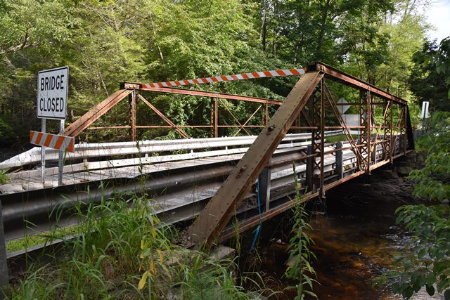
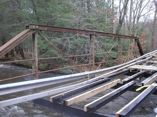
This bridge is a rare example of an early Penn Bridge Company truss bridge that contains the distinctive and unusual details of its builder. In particular, the essential detail of having two pins at the ends of the top chord is present on this bridge. One pin is for the diagonal member, the other is for the hip vertical. This odd connection style drives many modern engineers crazy because in their eyes this detail does not make sense. Regardless, these bridges have stood the test of time. The other distinctive detail is the unusual "adjustable eye bolt" that can be found at the base of the hip verticals.
This county-owned bridge had deteriorated and was closed to traffic following an inspection. The county weighed the value of replacing the bridge versus making some in-house repairs to the deck which would correct the bridge-closing deficiencies, and found that the repairs could be made for a mere fraction the cost of replacement. In other others, this bridge could be preserved, saving a valuable piece of history, while also saving tax dollars. Located on a quiet rural road, the one-lane bridge is enough to serve the functional needs of the road. Therefore, the county went ahead with a repair project in 2010. The cost was around $35,000, with $30,000 for bidded materials, and another $5,000 spent on additional materials by the county. The estimated cost of demolishing and replacing this bridge would have cost a staggering $1,500,000! The preservation of this bridge was a win-win scenario. All work was done in-house by the county, which helps reduce cost as well as a lot of the red tape and bureaucratic chaos that would have been associated with a replacement project.
This exemplary preservation project demonstrates how counties and other local agencies can take the initiative and preserve their historic bridges, even without pressure or even funding from the state or federal level.
Information and Findings From Pennsylvania's Historic Bridge InventoryDiscussion of Bridge The single span, 63'-long, pin connected, wrought iron, Pratt pony truss bridge is supported on stone abutments. The bridge is composed of built-up sections for the compression members, and eye bars and rods for the tension members. It has an uncommon double pin connection at the end post-upper chord connections, and an unusual adjustable eye bolt detail at the hip vertical-lower chord connection. Both details are associated with the Penn Bridge Co. of Beaver Falls, one of the earliest and most prolific metal truss bridge fabricators in Pennsylvania. The bridge is an early example of its type/design with proprietary details by an important in-state fabricator. It has minor alterations, such as strengthening of one of the end posts with a welded box section sleeve, but these have not had a significant impact on the over all integrity of original design. The bridge is historically and technologically significant. Discussion of Surrounding Area The bridge carries a 2 lane road over a stream in a rural setting with scattered 19th to late 20th century residences. At the north end is a late 19th century grist mill that has been converted to apartments. At the southwest quadrant is an altered late 19th century vernacular frame residence. The other quadrants are wooded. The setting does not have the cohesiveness or integrity of a historic district. Bridge Considered Historic By Survey: Yes |
This bridge is tagged with the following special condition(s): Unorganized Photos
![]()
Photo Galleries and Videos: Mill Mountain Road Bridge
Bridge Photo-Documentation
Original / Full Size PhotosA collection of overview and detail photos. This gallery offers photos in the highest available resolution and file size in a touch-friendly popup viewer.
Alternatively, Browse Without Using Viewer
![]()
Bridge Photo-Documentation
Mobile Optimized PhotosA collection of overview and detail photos. This gallery features data-friendly, fast-loading photos in a touch-friendly popup viewer.
Alternatively, Browse Without Using Viewer
![]()
Additional Unorganized Photos
Original / Full Size PhotosA supplemental collection of photos that are from additional visit(s) to the bridge and have not been organized or captioned. This gallery offers photos in the highest available resolution and file size in a touch-friendly popup viewer.
Alternatively, Browse Without Using Viewer
![]()
Additional Unorganized Photos
Mobile Optimized PhotosA supplemental collection of photos that are from additional visit(s) to the bridge and have not been organized or captioned. This gallery features data-friendly, fast-loading photos in a touch-friendly popup viewer.
Alternatively, Browse Without Using Viewer
![]()
Maps and Links: Mill Mountain Road Bridge
Coordinates (Latitude, Longitude):
Search For Additional Bridge Listings:
Bridgehunter.com: View listed bridges within 0.5 miles (0.8 kilometers) of this bridge.
Bridgehunter.com: View listed bridges within 10 miles (16 kilometers) of this bridge.
Additional Maps:
Google Streetview (If Available)
GeoHack (Additional Links and Coordinates)
Apple Maps (Via DuckDuckGo Search)
Apple Maps (Apple devices only)
Android: Open Location In Your Map or GPS App
Flickr Gallery (Find Nearby Photos)
Wikimedia Commons (Find Nearby Photos)
Directions Via Sygic For Android
Directions Via Sygic For iOS and Android Dolphin Browser
USGS National Map (United States Only)
Historical USGS Topo Maps (United States Only)
Historic Aerials (United States Only)
CalTopo Maps (United States Only)


