

View Information About HSR Ratings
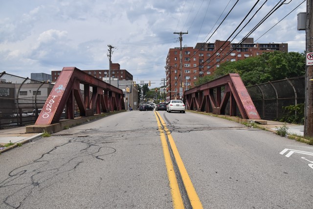
This classic pony truss with heavy members contributes to the history of the Pennsylvania Railroad mainline. The historic bridge inventory lists "Pennsylvania Railroad and City Department of Public Works" as the builder, although they may have been the designers, it is not known who fabricated or erected the truss.
Information and Findings From Pennsylvania's Historic Bridge InventoryDiscussion of Bridge The skewed, 1 span, 106'-long, rivet-connected Warren pony truss bridge built in 1924 is supported on ashlar abutments. The truss members are built up from standard steel sections. Built up floorbeams support rolled steel stringers and a concrete deck. Cantilevered sidewalks have original metal railings, but modern chain link fences have been attached. On the east side, a stairway has been built from the sidewalk to the busway. The bridge is a later example of its type and design that is not individually distinguished by its technology. The bridge's significance is in association with the development of the PHMC-determined eligible PRR Main Line. It dates from the line's period of significance and it is associated with efforts to improve the safety and efficiency of the line by improving grade crossings. The bridge was built as a joint project of the railroad and the city. Discussion of Surrounding Area The bridge carries a 2 lane street and 2 sidewalks over 2 active Conrail tracks and the Port Authority's East Busway. The setting is a mix of early 20th to late 20th century commercial and residential buildings. The railroad is the former Pennsylvania RR (PRR) Main Line, one of the most important transportation corridors in the nation. Originally 4 tracked, 2 tracks have been removed for the busway. The PRR Main Line from Philadelphia to Pittsburgh has been determined eligible by PHMC (DOE 9/14/93). Bridge Considered Historic By Survey: Yes |
This bridge is tagged with the following special condition(s): Unorganized Photos
![]()
![]()
![]()
Coordinates (Latitude, Longitude):
Search For Additional Bridge Listings:
Bridgehunter.com: View listed bridges within 0.5 miles (0.8 kilometers) of this bridge.
Bridgehunter.com: View listed bridges within 10 miles (16 kilometers) of this bridge.
Additional Maps:
Google Streetview (If Available)
GeoHack (Additional Links and Coordinates)
Apple Maps (Via DuckDuckGo Search)
Apple Maps (Apple devices only)
Android: Open Location In Your Map or GPS App
Flickr Gallery (Find Nearby Photos)
Wikimedia Commons (Find Nearby Photos)
Directions Via Sygic For Android
Directions Via Sygic For iOS and Android Dolphin Browser
USGS National Map (United States Only)
Historical USGS Topo Maps (United States Only)
Historic Aerials (United States Only)
CalTopo Maps (United States Only)

© Copyright 2003-2026, HistoricBridges.org. All Rights Reserved. Disclaimer: HistoricBridges.org is a volunteer group of private citizens. HistoricBridges.org is NOT a government agency, does not represent or work with any governmental agencies, nor is it in any way associated with any government agency or any non-profit organization. While we strive for accuracy in our factual content, HistoricBridges.org offers no guarantee of accuracy. Information is provided "as is" without warranty of any kind, either expressed or implied. Information could include technical inaccuracies or errors of omission. Opinions and commentary are the opinions of the respective HistoricBridges.org member who made them and do not necessarily represent the views of anyone else, including any outside photographers whose images may appear on the page in which the commentary appears. HistoricBridges.org does not bear any responsibility for any consequences resulting from the use of this or any other HistoricBridges.org information. Owners and users of bridges have the responsibility of correctly following all applicable laws, rules, and regulations, regardless of any HistoricBridges.org information.
![]()