

View Information About HSR Ratings
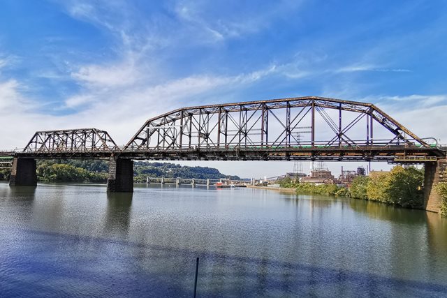
Featuring a wide variety of span types including those found on its long approaches, this unique bridge is difficult to access without a boat or a job with the railroad. Having secured access to a boat, HistoricBridges.org presents a large detail-oriented photo gallery for this bridge, but with the constraint that all photos are taken from the river. The main features of the bridge are the Pennsylvania truss span, which with five slopes, has the shape of a Camelback truss, and the Baltimore truss span. However there is much more to this bridge. The bridge's sprawling, branching approaches make this railroad bridge look more like an expressway interchange from above. These approach ramps include a pin connected Pratt deck truss span over Turtle Creek, riveted Warren deck truss spans, and even a riveted Pratt deck truss span. The remainder of the approaches are supported by mostly deck plate girder spans. Lengths given are estimates. The Pennsylvania truss span appears to be a 400 foot span while the Baltimore truss span appears to be 250 feet. The overall length estimate given is the shortest crossing, straight across the river and railroad tracks, and does not consider any of the branching elevated approach trackage.
This bridge is next to another railroad bridge.
![]()
![]()
![]()
Coordinates (Latitude, Longitude):
Search For Additional Bridge Listings:
Bridgehunter.com: View listed bridges within 0.5 miles (0.8 kilometers) of this bridge.
Bridgehunter.com: View listed bridges within 10 miles (16 kilometers) of this bridge.
Additional Maps:
Google Streetview (If Available)
GeoHack (Additional Links and Coordinates)
Apple Maps (Via DuckDuckGo Search)
Apple Maps (Apple devices only)
Android: Open Location In Your Map or GPS App
Flickr Gallery (Find Nearby Photos)
Wikimedia Commons (Find Nearby Photos)
Directions Via Sygic For Android
Directions Via Sygic For iOS and Android Dolphin Browser
USGS National Map (United States Only)
Historical USGS Topo Maps (United States Only)
Historic Aerials (United States Only)
CalTopo Maps (United States Only)

© Copyright 2003-2026, HistoricBridges.org. All Rights Reserved. Disclaimer: HistoricBridges.org is a volunteer group of private citizens. HistoricBridges.org is NOT a government agency, does not represent or work with any governmental agencies, nor is it in any way associated with any government agency or any non-profit organization. While we strive for accuracy in our factual content, HistoricBridges.org offers no guarantee of accuracy. Information is provided "as is" without warranty of any kind, either expressed or implied. Information could include technical inaccuracies or errors of omission. Opinions and commentary are the opinions of the respective HistoricBridges.org member who made them and do not necessarily represent the views of anyone else, including any outside photographers whose images may appear on the page in which the commentary appears. HistoricBridges.org does not bear any responsibility for any consequences resulting from the use of this or any other HistoricBridges.org information. Owners and users of bridges have the responsibility of correctly following all applicable laws, rules, and regulations, regardless of any HistoricBridges.org information.
![]()