

View Information About HSR Ratings
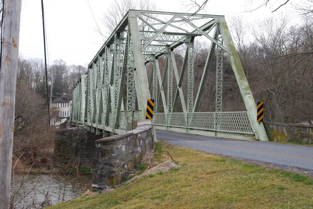
This bridge was built in 1923. In some respects it looks like a 1923 bridge, with members that are a little heavier than earlier bridge, but in many ways it still looks like a bridge from earlier years with its narrow roadway, and simple a-frame portal bracing. The bridge has struts (sway bracing) of an unusual lattice design. The bridge also retains large lattice railings. V-lacing is present on other truss members. The plentiful v-lacing and lattice on this bridge make it look quite visually complex.
Information and Findings From Pennsylvania's Historic Bridge InventoryDiscussion of Bridge The 2-span, 256'-long, rivet-connected Pratt thru truss bridge built in 1923 has all built-up members of standard steel sections. It has lattice railings, rolled floorbeams and stringers, open steel grid deck, and fieldstone abutments and pier with concrete caps. The rivet connected Pratt thru truss type/design came into increasing use in the 1890s as a result of improvements in field pneumatic riveting equipment, and it was common by the first decade of the 20th century for highway applications. The Pratt truss type/design is the most common in the state with over 375 examples. This later example is complete, but it has no unusual or noteworthy features. The bridge is not historically or technologically distinguished by its setting or context. It is not located in a potential historic district. Discussion of Surrounding Area The bridge carries 1 lane of a 2 lane road over a stream in a rural village setting of Rockhill. At the western quadrants are modern modular homes and altered late 19th century brick vernacular houses. At the east end is a T-shaped intersection with a local road, woods and open fields. A stone dam is upstream and a filled-in mill race is under the east span, but the associated mill has been lost. The setting does not have the cohesiveness or integrity of a historic district. Bridge Considered Historic By Survey: No |
![]()
![]()
![]()
Coordinates (Latitude, Longitude):
Search For Additional Bridge Listings:
Bridgehunter.com: View listed bridges within 0.5 miles (0.8 kilometers) of this bridge.
Bridgehunter.com: View listed bridges within 10 miles (16 kilometers) of this bridge.
Additional Maps:
Google Streetview (If Available)
GeoHack (Additional Links and Coordinates)
Apple Maps (Via DuckDuckGo Search)
Apple Maps (Apple devices only)
Android: Open Location In Your Map or GPS App
Flickr Gallery (Find Nearby Photos)
Wikimedia Commons (Find Nearby Photos)
Directions Via Sygic For Android
Directions Via Sygic For iOS and Android Dolphin Browser
USGS National Map (United States Only)
Historical USGS Topo Maps (United States Only)
Historic Aerials (United States Only)
CalTopo Maps (United States Only)

© Copyright 2003-2026, HistoricBridges.org. All Rights Reserved. Disclaimer: HistoricBridges.org is a volunteer group of private citizens. HistoricBridges.org is NOT a government agency, does not represent or work with any governmental agencies, nor is it in any way associated with any government agency or any non-profit organization. While we strive for accuracy in our factual content, HistoricBridges.org offers no guarantee of accuracy. Information is provided "as is" without warranty of any kind, either expressed or implied. Information could include technical inaccuracies or errors of omission. Opinions and commentary are the opinions of the respective HistoricBridges.org member who made them and do not necessarily represent the views of anyone else, including any outside photographers whose images may appear on the page in which the commentary appears. HistoricBridges.org does not bear any responsibility for any consequences resulting from the use of this or any other HistoricBridges.org information. Owners and users of bridges have the responsibility of correctly following all applicable laws, rules, and regulations, regardless of any HistoricBridges.org information.
![]()