

View Information About HSR Ratings
This bridge is noted for its unusual double arch ring, and for crossing the road and creek in a single span.
The stone arch was built in 1871 by the Northern Central Railway when the line was double tracked. It has been NR-listed as a historically significant example of its type / design by the Railroad Resources of York County Multiple Property Documentation.
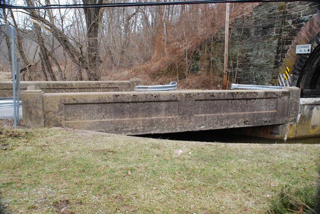
Information and Findings From Pennsylvania's Historic Bridge InventoryDiscussion of Bridge The skewed, single span, 35'-long, reinforced concrete thru girder bridge built in 1910 has an integral slab deck. The girders, which also serve as parapets, are paneled. The bridge is supported on concrete abutments. The bridge has been strengthened by H-piles with steel cap beams placed adjacent to the west abutment (ca. 1970). The underpinning has not significantly affected the bridge's appearance or integrity of original design. Like other reinforced concrete bridge types, such as T beams and slabs, thru girder bridges appeared during the first decade of the 20th century. In Pennsylvania, the type was never widely popular, and it was used mainly in a small number of counties. This example is one of the oldest and most complete examples in southeastern Pennsylvania (PADOT Districts 6 & 8) , and one of the two oldest identified examples from 1909-1910 in York County. It is historically and technologically significant as an early and complete application of the technology. In addition to its individual significance, the bridge is structurally associated with the historically significant NR-listed 1871 stone arch bridge that carries the railroad over the road and the stream. The 1910 thru girder bridge was built to replace a previous structure that carried the road over the stream and through the arch. Discussion of Surrounding Area The 1 lane bridge carries a 2 lane highway over a stream in a setting of predominately scattered mid to late 20th century houses including mobile homes at the southwest quadrant. The bridge is at the downstream opening of a stone arch bridge that carries a track of Conrail over the stream and the road. The road is carried through the arch on a section of fill that is retained by a concrete wall that is contiguous with the highway bridge. The stone arch was built in 1871 by the Northern Central Railway when the line was double tracked. It has been NR-listed as a historically significant example of its type/design by the Railroad Resources of York County Multiple Property Documentation (NR-listed 5/4/95). Bridge Considered Historic By Survey: Yes |
![]()
![]()
![]()
Coordinates (Latitude, Longitude):
Search For Additional Bridge Listings:
Bridgehunter.com: View listed bridges within 0.5 miles (0.8 kilometers) of this bridge.
Bridgehunter.com: View listed bridges within 10 miles (16 kilometers) of this bridge.
Additional Maps:
Google Streetview (If Available)
GeoHack (Additional Links and Coordinates)
Apple Maps (Via DuckDuckGo Search)
Apple Maps (Apple devices only)
Android: Open Location In Your Map or GPS App
Flickr Gallery (Find Nearby Photos)
Wikimedia Commons (Find Nearby Photos)
Directions Via Sygic For Android
Directions Via Sygic For iOS and Android Dolphin Browser
USGS National Map (United States Only)
Historical USGS Topo Maps (United States Only)
Historic Aerials (United States Only)
CalTopo Maps (United States Only)

© Copyright 2003-2026, HistoricBridges.org. All Rights Reserved. Disclaimer: HistoricBridges.org is a volunteer group of private citizens. HistoricBridges.org is NOT a government agency, does not represent or work with any governmental agencies, nor is it in any way associated with any government agency or any non-profit organization. While we strive for accuracy in our factual content, HistoricBridges.org offers no guarantee of accuracy. Information is provided "as is" without warranty of any kind, either expressed or implied. Information could include technical inaccuracies or errors of omission. Opinions and commentary are the opinions of the respective HistoricBridges.org member who made them and do not necessarily represent the views of anyone else, including any outside photographers whose images may appear on the page in which the commentary appears. HistoricBridges.org does not bear any responsibility for any consequences resulting from the use of this or any other HistoricBridges.org information. Owners and users of bridges have the responsibility of correctly following all applicable laws, rules, and regulations, regardless of any HistoricBridges.org information.
![]()