We Recommend:
Bach Steel - Experts at historic truss bridge restoration.
BridgeHunter.com Phase 1 is released to the public! - Visit Now
Shippingport Bridge
Midland - Shippingport Bridge

Primary Photographer(s): Nathan Holth
Bridge Documented: July 1, 2014
Shippingport and Midland: Beaver County, Pennsylvania: United States
Metal Continuous (Arched) 20 Panel Rivet-Connected Warren Through Truss, Fixed and Approach Spans: Metal Continuous Deck Girder, Fixed
1961 By Builder/Contractor: Unknown and Engineer/Design: Michael Baker Jr. Inc.
Not Available or Not Applicable
620.0 Feet (189 Meters)
1,616.0 Feet (492.6 Meters)
30 Feet (9.14 Meters)
3 Main Span(s) and 3 Approach Span(s)
3593

View Information About HSR Ratings
Bridge Documentation
View Archived National Bridge Inventory Report - Has Additional Details and Evaluation
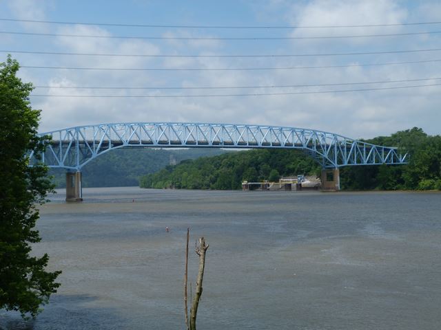
This bridge is a late example of a riveted truss bridge, having been built around less than ten years before rivets generally ceased to be used in new bridge construction. The bridge is however noteworthy as a rare (and visually pleasing) variety of continuous truss bridge, which features an arched design, where a deck truss approach transitions into a through truss for the central span. Unlike some examples of this bridge type, this one does not require a suspended deck.
The details of this bridge, particularly the portal bracing are similar to the Monaca - East Rochester Bridge. Based on the plan sheets for this bridge, it appears that with the Shippingport Bridge, the structure was designed by the state, but with some consulting engineering assistance from Michael Baker. Michael Baker also was a consulting engineer for the Monaca - East Rochester Bridge.
This bridge is located next to a nuclear power plant, and although the bridge has nothing to do with this and the bridge is on a public road, there are all sorts of threatening signs saying that parking, and even stopping on the bridge is forbidden. Locals indicated that anyone seen walking on the bridge and taking photos would likely receive an unwelcome visit from police in short order. It is sad that nobody can really enjoy this bridge just because it has the misfortune to be located in an area where constitutional freedoms come to a screeching halt. As a result, on-bridge photo documentation is limited for this bridge, although GoPro CarCam photos are available.
![]()
Photo Galleries and Videos: Shippingport Bridge
Bridge Photo-Documentation
Original / Full Size PhotosA collection of overview and detail photos. This gallery offers photos in the highest available resolution and file size in a touch-friendly popup viewer.
Alternatively, Browse Without Using Viewer
![]()
Bridge Photo-Documentation
Mobile Optimized PhotosA collection of overview and detail photos. This gallery features data-friendly, fast-loading photos in a touch-friendly popup viewer.
Alternatively, Browse Without Using Viewer
![]()
CarCam: Southbound Crossing
Full Motion VideoNote: The downloadable high quality version of this video (available on the video page) is well worth the download since it offers excellent 1080 HD detail and is vastly more impressive than the compressed streaming video. Streaming video of the bridge. Also includes a higher quality downloadable video for greater clarity or offline viewing.
![]()
Maps and Links: Shippingport Bridge
Coordinates (Latitude, Longitude):
Search For Additional Bridge Listings:
Bridgehunter.com: View listed bridges within 0.5 miles (0.8 kilometers) of this bridge.
Bridgehunter.com: View listed bridges within 10 miles (16 kilometers) of this bridge.
Additional Maps:
Google Streetview (If Available)
GeoHack (Additional Links and Coordinates)
Apple Maps (Via DuckDuckGo Search)
Apple Maps (Apple devices only)
Android: Open Location In Your Map or GPS App
Flickr Gallery (Find Nearby Photos)
Wikimedia Commons (Find Nearby Photos)
Directions Via Sygic For Android
Directions Via Sygic For iOS and Android Dolphin Browser
USGS National Map (United States Only)
Historical USGS Topo Maps (United States Only)
Historic Aerials (United States Only)
CalTopo Maps (United States Only)


