

View Information About HSR Ratings
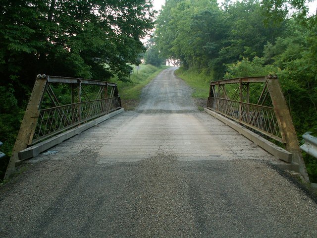
This bridge featured a rare design in that the diagonals and the bottom chord extend through the end post and end with a threaded rod and nut connection. This is an unusual and distinctive detail of many pony trusses that were built by the Wrought Iron Bridge Company. Other examples of this unusual design can be found in the state of Ohio, although they are rare there as well. In Pennsylvania they are even more rare, no thanks to the demolition of this historic bridge. Beyond the unusual connection design, the bridge was an otherwise traditionally composed, small half-hip Pratt pony truss bridge, composed of three panels. The bridge had a wooden deck, and it retained lattice railings. Its historic integrity was good.
The demolition of this bridge is a perfect example of what is wrong with the way Pennsylvania treats our nation's transportation heritage. Section 106 mitigation for the demolition of this bridge was to create a "state level recordation" which is usually little more than a "book report" about the bridge with a few photos. The report and photos are given to the State Historic Preservation Office (SHPO) never to be seen again. These documents are not made available online to the public, despite past requests by HistoricBridges.org. As such, the recordations are a waste of money. Also, a few parts of the bridge were to be donated to the historical society. What should have been done with this bridge? At the very least, as mitigation, the bridge was so small it would have been extremely easy (and inexpensive) to lift it off its abutments and either put it on display in a park setting (or at the historical society's property), or even put it in storage and make it available for reuse. Indiana does the latter when it cannot find a new home for a bridge prior to replacement. Indiana will often store the bridge for up to 10 years, keeping it available for reuse. It is easier for a third party to acquire the bridge at this time because the bridge is instantly available, and the new owner does not have to coordinate with the bridge replacement schedule. Pennsylvania however only offers the bridge for reuse prior to the replacement. Once the replacement project takes place, the bridge is reduced to scrap metal. It is not right that Indiana can make a serious effort to find new homes for its historic bridges (which it is often successful in doing) while Pennsylvania is allowed to continue this pattern of demolition. Unlike Indiana, Pennsylvania does not have success finding new homes for bridges, likely due to the aforementioned issues.
Information and Findings From Pennsylvania's Historic Bridge InventoryDiscussion of Bridge The ca. 1888, pin connected, single span, 46'-long, Pratt pony truss bridge is attributed to the Wrought Iron Bridge Company because it has the distinctive upper and lower chord cast iron connections found on documented bridges by the prominent Ohio bridge designer and fabricator. The bridge appears to be complete, and it stands out in the county as one of the important metal truss bridges that chronicle the evolution of the development and eventual standardization of the technology. The bridge is historically and technologically significant. Discussion of Surrounding Area The bridge carries 1 lane of a 2 lane, unimproved township road over a stream in a rural area with scattered, undistinguished late 20th century residences. The area does not have historic district potential. Bridge Considered Historic By Survey: Yes |
![]()
![]()
![]()
This historic bridge has been demolished. This map is shown for reference purposes only.
Coordinates (Latitude, Longitude):
Search For Additional Bridge Listings:
Bridgehunter.com: View listed bridges within 0.5 miles (0.8 kilometers) of this bridge.
Bridgehunter.com: View listed bridges within 10 miles (16 kilometers) of this bridge.
Additional Maps:
Google Streetview (If Available)
GeoHack (Additional Links and Coordinates)
Apple Maps (Via DuckDuckGo Search)
Apple Maps (Apple devices only)
Android: Open Location In Your Map or GPS App
Flickr Gallery (Find Nearby Photos)
Wikimedia Commons (Find Nearby Photos)
Directions Via Sygic For Android
Directions Via Sygic For iOS and Android Dolphin Browser
USGS National Map (United States Only)
Historical USGS Topo Maps (United States Only)
Historic Aerials (United States Only)
CalTopo Maps (United States Only)

© Copyright 2003-2026, HistoricBridges.org. All Rights Reserved. Disclaimer: HistoricBridges.org is a volunteer group of private citizens. HistoricBridges.org is NOT a government agency, does not represent or work with any governmental agencies, nor is it in any way associated with any government agency or any non-profit organization. While we strive for accuracy in our factual content, HistoricBridges.org offers no guarantee of accuracy. Information is provided "as is" without warranty of any kind, either expressed or implied. Information could include technical inaccuracies or errors of omission. Opinions and commentary are the opinions of the respective HistoricBridges.org member who made them and do not necessarily represent the views of anyone else, including any outside photographers whose images may appear on the page in which the commentary appears. HistoricBridges.org does not bear any responsibility for any consequences resulting from the use of this or any other HistoricBridges.org information. Owners and users of bridges have the responsibility of correctly following all applicable laws, rules, and regulations, regardless of any HistoricBridges.org information.
![]()