We Recommend:
Bach Steel - Experts at historic truss bridge restoration.
BridgeHunter.com Phase 1 is released to the public! - Visit Now
Wolf Bridge

Primary Photographer(s): Nathan Holth and Rick McOmber
Bridge Documented: May 31, 2010
Rural: Cumberland County, Pennsylvania: United States
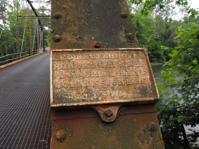
1895 By Builder/Contractor: Pittsburgh Bridge Company of Pittsburgh, Pennsylvania, Nelson and Buchanan of Chambersburg, Pennsylvania Agents
1955
190.0 Feet (57.9 Meters)
192.0 Feet (58.5 Meters)
14.8 Feet (4.51 Meters)
1 Main Span(s)
21720605083611

View Information About HSR Ratings
Bridge Documentation
This bridge no longer exists!
Bridge Status: Demolished and replaced ca. 2021.View Archived National Bridge Inventory Report - Has Additional Details and Evaluation
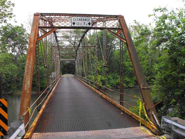
This bridge is a beautiful example of a pin-connected Pennsylvania through truss. Although Cumberland County happens to have more than one example, this truss type is very uncommon and all surviving examples of this type should be marked for preservation.
The bridge was damaged and closed to traffic on May 29, 2010 when a drunk driver crashed his vehicle into the bridge, nearly cracking a vertical member in two. Even with this damage, restoring this bridge remains very feasible. The damaged vertical could either be repaired or replicated and replaced. As for the rest of the bridge, the truss remains in decent condition. Prior to closure, rehabilitation was recommended by the National Bridge Inventory, which normally recommends replacement for bridges of this type, even if rehabilitation is feasible in reality.
If the number of innocent victims on the road who get killed by drunk drivers is not enough evidence for the need to punish people who drive drunk more severely, then consider the cost in terms of historic bridges! Laws should be in place that anyone who destroys a historic bridge due to negligence or drunkenness be forced to pay for the bridge's complete restoration.
The damage to this bridge also should serve as a warning to preservationists as well. As preservationists, there is a temptation to frown at rehabilitation projects that place modern guardrails on a historic bridge. However HistoricBridges.org strongly recommends the placement of crash-tested guardrails that protect the superstructure of pony and through truss bridge as part of rehabilitation projects for the simple reason that if bridges are not protected by these guardrails, they remain at risk for damage by vehicles. However at the same time, HistoricBridges.org also recommends that if original railings remain on these bridges, that the original railings be left in place behind the new guardrails to maintain the historic integrity and beauty of the bridge.
Information and Findings From Pennsylvania's Historic Bridge InventoryDiscussion of Bridge The one-span, 190'-long, pin-connected, Pennsylvania thru truss bridge built in 1895 is composed of built-up sections and eye bars. It is supported on stone abutments with wingwalls. The open steel grid deck and stringers were placed in 1955. Plates have been welded to the verticals above the lower panel points. W-beam guide railings have replaced the earlier railings. The bridge has Z-plate floorbeam hangers, a detail distinctive of the fabricator, the Pittsburgh Bridge Co. It was erected by their agents Nelson & Buchanan of Chambersburg. The Pennsylvania truss design, a variation of the Pratt truss with subdivided panels and polygonal upper chord, was developed in about 1875 by bridge engineers of the Pennsylvania RR. The design was used primarily for long-span railroad applications, but found some popularity for long-span (approx. 200') highway applications from about 1890 to 1910, and it continued to be used in the state through the 1930s, though most later examples are rivet connected. The survey has identified at least four pre-1900 examples of Pennsylvania thru truss highway bridges. This example has alterations but they do not compromise the overall integrity of original design or workmanship. The bridge is historically and technologically significant as an increasingly rare type and design. Discussion of Surrounding Area The bridge carries a 2 lane road over a stream in a rural area of active farms and scattered late-20th-century residential subdivisions northeast of Carlisle. Bridge Considered Historic By Survey: Yes |
![]()
Photo Galleries and Videos: Wolf Bridge
Structure Overview
Original / Full Size PhotosA collection of overview photos that show the bridge as a whole and general areas of the bridge. This gallery offers photos in the highest available resolution and file size in a touch-friendly popup viewer.
Alternatively, Browse Without Using Viewer
![]()
Structure Details
Original / Full Size PhotosA collection of detail photos that document the parts, construction, and condition of the bridge. This gallery offers photos in the highest available resolution and file size in a touch-friendly popup viewer.
Alternatively, Browse Without Using Viewer
![]()
Structure Overview
Mobile Optimized PhotosA collection of overview photos that show the bridge as a whole and general areas of the bridge. This gallery features data-friendly, fast-loading photos in a touch-friendly popup viewer.
Alternatively, Browse Without Using Viewer
![]()
Structure Details
Mobile Optimized PhotosA collection of detail photos that document the parts, construction, and condition of the bridge. This gallery features data-friendly, fast-loading photos in a touch-friendly popup viewer.
Alternatively, Browse Without Using Viewer
![]()
Maps and Links: Wolf Bridge
This historic bridge has been demolished. This map is shown for reference purposes only.
Coordinates (Latitude, Longitude):
Search For Additional Bridge Listings:
Bridgehunter.com: View listed bridges within 0.5 miles (0.8 kilometers) of this bridge.
Bridgehunter.com: View listed bridges within 10 miles (16 kilometers) of this bridge.
Additional Maps:
Google Streetview (If Available)
GeoHack (Additional Links and Coordinates)
Apple Maps (Via DuckDuckGo Search)
Apple Maps (Apple devices only)
Android: Open Location In Your Map or GPS App
Flickr Gallery (Find Nearby Photos)
Wikimedia Commons (Find Nearby Photos)
Directions Via Sygic For Android
Directions Via Sygic For iOS and Android Dolphin Browser
USGS National Map (United States Only)
Historical USGS Topo Maps (United States Only)
Historic Aerials (United States Only)
CalTopo Maps (United States Only)


