We Recommend:
Bach Steel - Experts at historic truss bridge restoration.
31st Street Bridge

Primary Photographer(s): Nathan Holth
Bridge Documented: August 1, 2010
31st Street (PA-2122) Over Allegheny River, Railroad, and Local Streets
Pittsburgh: Allegheny County, Pennsylvania: United States
Metal Three-Hinged Solid Ribbed Deck Arch, Fixed and Approach Spans: Metal Continuous Girder, Fixed
1928 By Builder/Contractor: Fort Pitt Bridge Works of Pittsburgh, Pennsylvania and Engineer/Design: Allegheny County Department of Public Works
2007
380.0 Feet (115.8 Meters)
2,681.0 Feet (817.2 Meters)
28 Feet (8.53 Meters)
3 Main Span(s) and 23 Approach Span(s)
2212200100025

View Information About HSR Ratings
Bridge Documentation
View Archived National Bridge Inventory Report - Has Additional Details and Evaluation
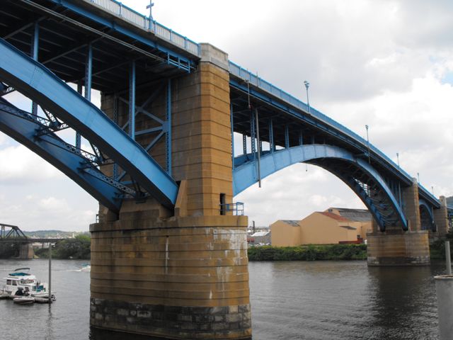
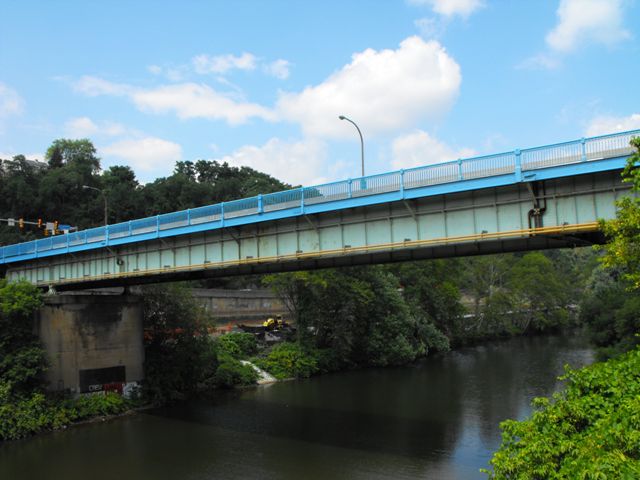
This bridge is one of two similar but different deck arch bridges along this stretch of the Allegheny River. A structure of monumental size, this bridge carries 31st Street over the Allegheny River as well as various local streets. The main portion of the bridge is three steel deck arch spans, with the central span being the largest and having three hinges, while the smaller spans have two hinges. The approach spans are mostly deck plate girders. Among the approach spans, the spans at the northern end are most noteworthy. At the northern end of the bridge, there is a through girder span over the railroad which is partially concrete encased. This single span plate girder is highly unusual because the girders are spaced further apart at one end than the other, so that the roadway at the northern end of the bridge is wider. Just south of this girder span, their is a cantilevered deck plate girder with a suspended span that crosses the back channel of the Allegheny River.
This bridge was extensively rehabilitated in 2007, with an attractive blue paint placed on the bridge as well, replacing a former pale green color. The original ornate railings of this bridge were retained as part of this rehabilitation, representing the retention of an aspect of the bridge that is important both from an aesthetic standpoint as well as from a historic integrity standpoint. The rehabilitation of the main span superstructure was done very nicely, although it would have been nice to see the sway/lateral bracing members that were replaced on the bridge replaced in-kind. Those bracing members which were replaced are rolled beams with unusual punched shapes of ovals and hexagons, and do not match the original latticed built-up beams. On the approach system, the replacement of original material was more extensive, with many of the approach span superstructures being replaced completely. On the other hand, the substructure of the bridge including beautiful, massive built-up steel bents was retained. At the time of documentation, the railroad overpass span and the back channel span, both at the northern end of the bridge remained. However, these spans are slated for demolition and replacement as part of the continuing project which has been executed in multiple stages. The River Avenue Ramp which leads up to this bridge contains a substructure that is not part of the 31st Street bridge, but instead part of the previous 30th Street Bridge which provides access to Herr's Island. The previous 30th Street Bridge was a truss bridge, but it no longer remains, although the approach system remained at the time of documentation. This may also be removed however as part of the continuing rehabilitation project. Because it appears the majority of the structure at the northern end of the bridge

Although this rehabilitation did alter the bridge, the fact that the rehabilitation was so extensive should mean that with routine maintenance and repair, this bridge should be able to look forward to upwards of a century of service. The bridge remains today as one of the beautiful landmark bridges that makes Pittsburgh one of the greatest cities in the world for historic bridges.
During the field visit by HistoricBridges.org, the enormous plaques were missing from the decorative pillars of this bridge which rise above the roadway at piers on the main spans, but it is assumed these were being repaired and will be placed back on the bridge.
More information is available at BridgeMapper and PGHBridges.

![]()
Photo Galleries and Videos: 31st Street Bridge
Bridge Documentation
Original / Full Size PhotosPhotos of all parts of the bridge except the northern approach spans. This gallery offers photos in the highest available resolution and file size in a touch-friendly popup viewer.
Alternatively, Browse Without Using Viewer
![]()
Bridge Documentation
Mobile Optimized PhotosPhotos of all parts of the bridge except the northern approach spans. This gallery features data-friendly, fast-loading photos in a touch-friendly popup viewer.
Alternatively, Browse Without Using Viewer
![]()
Northern Approach Spans
Original / Full Size PhotosPhotos of the northern approach spans. Because these spans are slated for removal a detailed photo-documentation was made of them. This gallery offers photos in the highest available resolution and file size in a touch-friendly popup viewer.
Alternatively, Browse Without Using Viewer
![]()
Northern Approach Spans
Mobile Optimized PhotosPhotos of the approach spans at the northern end including back channel, 30th Street ramp, and railroad overpass. Because these spans are slated for removal a detailed photo-documentation was made of them. This gallery features data-friendly, fast-loading photos in a touch-friendly popup viewer.
Alternatively, Browse Without Using Viewer
![]()
Maps and Links: 31st Street Bridge
Coordinates (Latitude, Longitude):
Search For Additional Bridge Listings:
Bridgehunter.com: View listed bridges within 0.5 miles (0.8 kilometers) of this bridge.
Bridgehunter.com: View listed bridges within 10 miles (16 kilometers) of this bridge.
Additional Maps:
Google Streetview (If Available)
GeoHack (Additional Links and Coordinates)
Apple Maps (Via DuckDuckGo Search)
Apple Maps (Apple devices only)
Android: Open Location In Your Map or GPS App
Flickr Gallery (Find Nearby Photos)
Wikimedia Commons (Find Nearby Photos)
Directions Via Sygic For Android
Directions Via Sygic For iOS and Android Dolphin Browser
USGS National Map (United States Only)
Historical USGS Topo Maps (United States Only)
Historic Aerials (United States Only)
CalTopo Maps (United States Only)


