

View Information About HSR Ratings
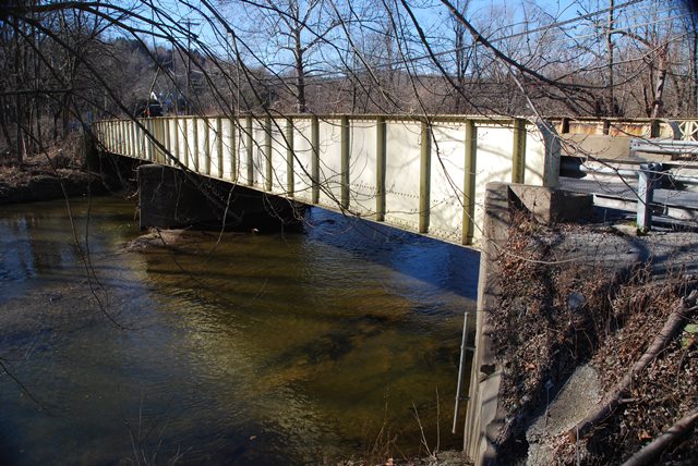
This is a good example of a state standard plan through girder. It retains lattice railings on its cantilevered sidewalk, which is something not found on all surviving bridges of this type in Pennsylvania.
Information and Findings From Pennsylvania's Historic Bridge InventoryDiscussion of Bridge The skewed, 2 span, 140'-long thru girder bridge with floorbeams is supported on reinforced concrete abutments and pier. The bridge has a steel grid deck. In 1983 concrete safety shape barriers were added to the inside face of the built-up girders. A sidewalk with lattice railings is cantilevered from the downstream side of the bridge. The bridge was built in 1929 by the state highway department. The altered thru girder bridge is an example of a very common bridge type that was in widespread use from the mid-19th century through the mid- 20th century. Neither the bridge nor its setting or context are historically or technologically significant. Discussion of Surrounding Area The bridge carries a 2 lane road and a sidewalk over a stream in a sparsely developed, forested setting. Bridge Considered Historic By Survey: No |
![]()
![]()
![]()
This historic bridge has been demolished. This map is shown for reference purposes only.
Coordinates (Latitude, Longitude):
Search For Additional Bridge Listings:
Bridgehunter.com: View listed bridges within 0.5 miles (0.8 kilometers) of this bridge.
Bridgehunter.com: View listed bridges within 10 miles (16 kilometers) of this bridge.
Additional Maps:
Google Streetview (If Available)
GeoHack (Additional Links and Coordinates)
Apple Maps (Via DuckDuckGo Search)
Apple Maps (Apple devices only)
Android: Open Location In Your Map or GPS App
Flickr Gallery (Find Nearby Photos)
Wikimedia Commons (Find Nearby Photos)
Directions Via Sygic For Android
Directions Via Sygic For iOS and Android Dolphin Browser
USGS National Map (United States Only)
Historical USGS Topo Maps (United States Only)
Historic Aerials (United States Only)
CalTopo Maps (United States Only)

© Copyright 2003-2024, HistoricBridges.org. All Rights Reserved. Disclaimer: HistoricBridges.org is a volunteer group of private citizens. HistoricBridges.org is NOT a government agency, does not represent or work with any governmental agencies, nor is it in any way associated with any government agency or any non-profit organization. While we strive for accuracy in our factual content, HistoricBridges.org offers no guarantee of accuracy. Information is provided "as is" without warranty of any kind, either expressed or implied. Information could include technical inaccuracies or errors of omission. Opinions and commentary are the opinions of the respective HistoricBridges.org member who made them and do not necessarily represent the views of anyone else, including any outside photographers whose images may appear on the page in which the commentary appears. HistoricBridges.org does not bear any responsibility for any consequences resulting from the use of this or any other HistoricBridges.org information. Owners and users of bridges have the responsibility of correctly following all applicable laws, rules, and regulations, regardless of any HistoricBridges.org information.
![]()