

View Information About HSR Ratings
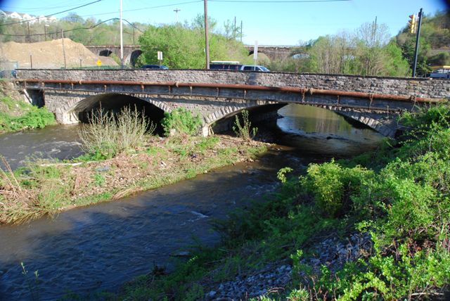
This is an attractive stone arch bridge and despite its location on the historic, well-traveled Lincoln Highway, is unaltered and has good historic integrity.
Information and Findings From Pennsylvania's Historic Bridge InventoryDiscussion of Bridge The 3 span bridge consists of two, 50'-long stone arch spans and a 12'-long encased steel stringer approach span. The bridge has stone parapets topped by pipe hand railings. The elliptical arches have concrete liners. The bridge built in 1914 appears to be a well preserved example of its type with no major alterations. The bridge is on the boundary of the Coatesville Historic District, but was not rated in the district nomination. The bridge dates from the district's period of significance (1750-1937) and is evaluated a contributing resource. The bridge is also historically significant for its early association with the Lincoln Highway. Discussion of Surrounding Area The bridge carries a 3 lane road and 2 sidewalks over the West Branch of Brandywine Creek in Coatesville. The creek forms the western boundary of the Coatesville Historic District that encompasses the town's mid-18th to early-20th century commercial and residential areas. The Lukens Steel Company plant is on the west bank of the creek. The bridge is on the route of Old US 30, the Lincoln Highway. The Lincoln Highway was a historically significant, ealry-20th century automobile tourist trail, that was established as a cross-state route by the early 1910s. Bridge Considered Historic By Survey: Yes |
![]()
![]()
![]()
Coordinates (Latitude, Longitude):
Search For Additional Bridge Listings:
Bridgehunter.com: View listed bridges within 0.5 miles (0.8 kilometers) of this bridge.
Bridgehunter.com: View listed bridges within 10 miles (16 kilometers) of this bridge.
Additional Maps:
Google Streetview (If Available)
GeoHack (Additional Links and Coordinates)
Apple Maps (Via DuckDuckGo Search)
Apple Maps (Apple devices only)
Android: Open Location In Your Map or GPS App
Flickr Gallery (Find Nearby Photos)
Wikimedia Commons (Find Nearby Photos)
Directions Via Sygic For Android
Directions Via Sygic For iOS and Android Dolphin Browser
USGS National Map (United States Only)
Historical USGS Topo Maps (United States Only)
Historic Aerials (United States Only)
CalTopo Maps (United States Only)

© Copyright 2003-2024, HistoricBridges.org. All Rights Reserved. Disclaimer: HistoricBridges.org is a volunteer group of private citizens. HistoricBridges.org is NOT a government agency, does not represent or work with any governmental agencies, nor is it in any way associated with any government agency or any non-profit organization. While we strive for accuracy in our factual content, HistoricBridges.org offers no guarantee of accuracy. Information is provided "as is" without warranty of any kind, either expressed or implied. Information could include technical inaccuracies or errors of omission. Opinions and commentary are the opinions of the respective HistoricBridges.org member who made them and do not necessarily represent the views of anyone else, including any outside photographers whose images may appear on the page in which the commentary appears. HistoricBridges.org does not bear any responsibility for any consequences resulting from the use of this or any other HistoricBridges.org information. Owners and users of bridges have the responsibility of correctly following all applicable laws, rules, and regulations, regardless of any HistoricBridges.org information.
![]()