

View Information About HSR Ratings
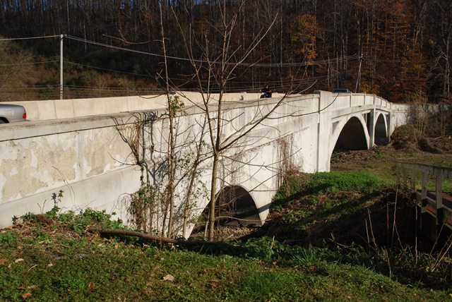
This bridge laid out in an unusual manner. It contains two larger open spandrel concrete arch spans, but there is also a smaller closed spandrel arch span. Open spandrel spans and closed spandrel span are separated by a section that is composed simply of concrete retaining walls with earth fill. According to the historic bridge inventory, portions of this bridge had balustrade railings. These are not present on here so the railings would appear to have been altered or replaced.
Information and Findings From Pennsylvania's Historic Bridge InventoryDiscussion of Bridge The 3 span, 220'-long bridge built in 1923 by the county consists of two, 75'-long, 2-ribbed, open spandrel arch spans over the main stream, a 50'-section of earth fill held by concrete retaining walls, and a 20' deck arch span over the mill race on the north bank of the creek. The bridge, located on an S-curve, has curved paneled parapets on the approaches and alternating balustrades and solid parapets on the bridge. The open spandrel arch spans have deep spalls on the fasciae and intrados of the ribs with exposed reinforcing bars, in some cases bent and dangling in mid-air. The bridge is a short and undistinguished example of its type and design with significant loss of original material due to spalling and deteriorated concrete. More distinguished examples built under the direction of the county engineer exist in Chester County (e.g. 15011303402798 and 15011303001047). The Embreeville HD boundaries were drawn to exclude the bridge's main spans and the bridge postdates the 1700-1899 period of significance. It is not historically associated with the district's themes of 19th-century rural industry and commerce. Thus, the bridge is a noncontributing resource. Discussion of Surrounding Area The bridge carries a 2 lane road over a stream and mill race in the small rural village of Embreeville. The village is a listed National Register historic district noteworthy for its 19thcentury residences and mill complex. The district extends to both sides of the stream, and the southwest side of the bridge was used as one of the district boundaries (see map). Thus, the bridge's north approach span over the mill race is within the district, and the two main spans are contiguous to the district. The bridge was not rated in the nomination. The grist mill is located downstream, approximately 400' northeast of the bridge. No buildings are immediately adjacent to the bridge. Bridge Considered Historic By Survey: No |
![]()
![]()
![]()
Coordinates (Latitude, Longitude):
Search For Additional Bridge Listings:
Bridgehunter.com: View listed bridges within 0.5 miles (0.8 kilometers) of this bridge.
Bridgehunter.com: View listed bridges within 10 miles (16 kilometers) of this bridge.
Additional Maps:
Google Streetview (If Available)
GeoHack (Additional Links and Coordinates)
Apple Maps (Via DuckDuckGo Search)
Apple Maps (Apple devices only)
Android: Open Location In Your Map or GPS App
Flickr Gallery (Find Nearby Photos)
Wikimedia Commons (Find Nearby Photos)
Directions Via Sygic For Android
Directions Via Sygic For iOS and Android Dolphin Browser
USGS National Map (United States Only)
Historical USGS Topo Maps (United States Only)
Historic Aerials (United States Only)
CalTopo Maps (United States Only)

© Copyright 2003-2024, HistoricBridges.org. All Rights Reserved. Disclaimer: HistoricBridges.org is a volunteer group of private citizens. HistoricBridges.org is NOT a government agency, does not represent or work with any governmental agencies, nor is it in any way associated with any government agency or any non-profit organization. While we strive for accuracy in our factual content, HistoricBridges.org offers no guarantee of accuracy. Information is provided "as is" without warranty of any kind, either expressed or implied. Information could include technical inaccuracies or errors of omission. Opinions and commentary are the opinions of the respective HistoricBridges.org member who made them and do not necessarily represent the views of anyone else, including any outside photographers whose images may appear on the page in which the commentary appears. HistoricBridges.org does not bear any responsibility for any consequences resulting from the use of this or any other HistoricBridges.org information. Owners and users of bridges have the responsibility of correctly following all applicable laws, rules, and regulations, regardless of any HistoricBridges.org information.
![]()