HistoricBridges.org Menu: HistoricBridges.org Menu:


We Recommend:
Bach Steel - Experts at historic truss bridge restoration.

HistoricBridges.org: Bridge Browser

Aspinwall Railroad Bridge

Aspinwall Railroad Bridge

Primary Photographer(s): Nathan Holth

Bridge Documented: November 4, 2019 and May 21, 2021

View Photos
and Videos
View Maps
and Links

Facility Carried / Feature Intersected
Railroad (Allegheny Valley Railroad) Over Allegheny River and Railroads
Location
Aspinwall and Pittsburgh: Allegheny County, Pennsylvania: United States
Structure Type
Metal 11 Panel Pin-Connected Parker Through Truss, Fixed and Approach Spans: Metal Deck Girder, Fixed
Rehabilitation Date
Not Available or Not Applicable
Main Span Length
410.0 Feet (125 Meters)
Structure Length
1,835.0 Feet (559.3 Meters)
Roadway Width
Not Available
Spans
3 Main Span(s)
Inventory Number
Not Applicable

Historic Significance Rating (HSR)
View Information About HSR Ratings

Bridge Documentation

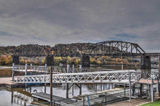
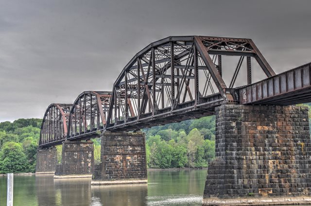
This large pin-connected through truss bridge also features an unusual Y approach structure at the north end. The northeastern part of the Y is particularly unusual as it passes over another railroad line and has some unusual bents that straddle the railroad tracks below, this design was to accomodate an elevated train station. The plate girder approach spans have American Bridge Company plaques on them but reportedly the Pennsylvania Steel Company also played a role in the bridge's construction.Lengths given are estimates, and the total length represents the length via the northwestern ramp, which is the only one still used by trains.


This bridge is tagged with the following special condition(s): Unorganized Photos

Divider

Photo Galleries and Videos: Aspinwall Railroad Bridge


View Photo Gallery

2019 Bridge Photo-Documentation

Original / Full Size Photos
A collection of overview and detail photos. This gallery offers photos in the highest available resolution and file size in a touch-friendly popup viewer.
Alternatively, Browse Without Using Viewer

Divider

View Photo Gallery

2019 Bridge Photo-Documentation

Mobile Optimized Photos
A collection of overview and detail photos. This gallery features data-friendly, fast-loading photos in a touch-friendly popup viewer.
Alternatively, Browse Without Using Viewer

Divider

View Photo Gallery

2021 Additional Unorganized Photos

Original / Full Size Photos
A supplemental collection of photos that are from additional visit(s) to the bridge and have not been organized or captioned. This gallery offers photos in the highest available resolution and file size in a touch-friendly popup viewer.
Alternatively, Browse Without Using Viewer

Divider

View Photo Gallery

2021 Additional Unorganized Photos

Mobile Optimized Photos
A supplemental collection of photos that are from additional visit(s) to the bridge and have not been organized or captioned. This gallery features data-friendly, fast-loading photos in a touch-friendly popup viewer.
Alternatively, Browse Without Using Viewer

Divider

Maps and Links: Aspinwall Railroad Bridge

Coordinates (Latitude, Longitude):

Search For Additional Bridge Listings:

Bridgehunter.com: View listed bridges within 0.5 miles (0.8 kilometers) of this bridge.

Bridgehunter.com: View listed bridges within 10 miles (16 kilometers) of this bridge.

HistoricBridges.org Bridge Browser: View listed bridges within 0.5 miles (0.8 kilometers) of this bridge.

HistoricBridges.org Bridge Browser: View listed bridges within 10 miles (16 kilometers) of this bridge.

2021 National Bridge Inventory: View listed bridges within 0.5 miles (0.8 kilometers) of this bridge.

Additional Maps:

Google Maps

Google Streetview (If Available)

Bing Maps

OpenStreetMap

GeoHack (Additional Links and Coordinates)

Apple Maps (Via DuckDuckGo Search)

Apple Maps (Apple devices only)

MapQuest

HERE We Go Maps

ACME Mapper

Waze Map

Android: Open Location In Your Map or GPS App

Flickr Gallery (Find Nearby Photos)

Wikimedia Commons (Find Nearby Photos)

Directions Via Sygic For Android

Directions Via Sygic For iOS and Android Dolphin Browser

USGS National Map (United States Only)

Historical USGS Topo Maps (United States Only)

Historic Aerials (United States Only)

CalTopo Maps (United States Only)


Divider
 
Home Top

Divider

About - Contact

© Copyright 2003-2024, HistoricBridges.org. All Rights Reserved. Disclaimer: HistoricBridges.org is a volunteer group of private citizens. HistoricBridges.org is NOT a government agency, does not represent or work with any governmental agencies, nor is it in any way associated with any government agency or any non-profit organization. While we strive for accuracy in our factual content, HistoricBridges.org offers no guarantee of accuracy. Information is provided "as is" without warranty of any kind, either expressed or implied. Information could include technical inaccuracies or errors of omission. Opinions and commentary are the opinions of the respective HistoricBridges.org member who made them and do not necessarily represent the views of anyone else, including any outside photographers whose images may appear on the page in which the commentary appears. HistoricBridges.org does not bear any responsibility for any consequences resulting from the use of this or any other HistoricBridges.org information. Owners and users of bridges have the responsibility of correctly following all applicable laws, rules, and regulations, regardless of any HistoricBridges.org information.

Admin Login

Divider