

View Information About HSR Ratings
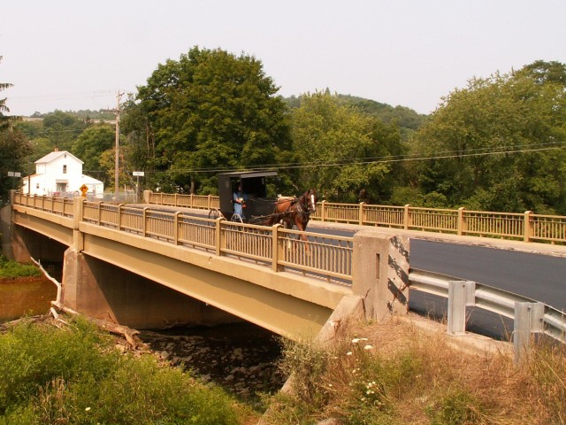
This bridge is an excellent example of a common style that Pennsylvania used for its bridges in the 1950s. The state's own unique style of railing is well-represented here and remains unhindered with no modern railing additions.
The Historic Bridge Inventory found the bridge non-historic. However, the SHPO appears to have found it eligible as part of the historic district, even though it falls out of the 1870-1930 district period of significance. HistoricBridges.org agrees with the SHPO's finding. Even if it falls out of the period of significance, it is worth noting that a 1950s bridge would fit in a historic district more so than a 2008 bridge would, and thus its preservation should still be considered.
Fortunately, the bridge appears to have been recently rehabilitated, and it appears to be in excellent condition and retains excellent historic integrity. This recent rehabilitation is quite unusual for PennDOT, which more often chooses to demolish aging bridges rather than save money and history by maintaining the existing bridge.
Information and Findings From Pennsylvania's Historic Bridge InventoryDiscussion of Bridge The 1951, 2 simple span, 147'-long, steel stringer bridge is supported on concrete abutments with wingwalls and a concrete pier. The bridge has a concrete filled steel grid deck and period steel railings with vertically scored concrete endposts. It is not individually significant as it is a late example of the most common 20th century bridge technology in the state. It is located on what is a boundary of the PHMC-determined eligible historic district, but it was built well after the ca. 1870-1930 period of significance and is thus noncontributing. Discussion of Surrounding Area The bridge carries a 2 lane road, 2 shoulders, and 1 sidewalk over the Casselman River on the west edge of Meyersdale borough. Most of the borough was determined by PHMC to be a historic district with a period of significance of ca. 1870 to 1930. Bridge Considered Historic By Survey: No (Despite Pennsylvania SHPO Findings: Eligible. Meyersdale HD. SHPO Finding. 12/15/1993.) |
![]()
![]()
Coordinates (Latitude, Longitude):
Search For Additional Bridge Listings:
Bridgehunter.com: View listed bridges within 0.5 miles (0.8 kilometers) of this bridge.
Bridgehunter.com: View listed bridges within 10 miles (16 kilometers) of this bridge.
Additional Maps:
Google Streetview (If Available)
GeoHack (Additional Links and Coordinates)
Apple Maps (Via DuckDuckGo Search)
Apple Maps (Apple devices only)
Android: Open Location In Your Map or GPS App
Flickr Gallery (Find Nearby Photos)
Wikimedia Commons (Find Nearby Photos)
Directions Via Sygic For Android
Directions Via Sygic For iOS and Android Dolphin Browser
USGS National Map (United States Only)
Historical USGS Topo Maps (United States Only)
Historic Aerials (United States Only)
CalTopo Maps (United States Only)

© Copyright 2003-2024, HistoricBridges.org. All Rights Reserved. Disclaimer: HistoricBridges.org is a volunteer group of private citizens. HistoricBridges.org is NOT a government agency, does not represent or work with any governmental agencies, nor is it in any way associated with any government agency or any non-profit organization. While we strive for accuracy in our factual content, HistoricBridges.org offers no guarantee of accuracy. Information is provided "as is" without warranty of any kind, either expressed or implied. Information could include technical inaccuracies or errors of omission. Opinions and commentary are the opinions of the respective HistoricBridges.org member who made them and do not necessarily represent the views of anyone else, including any outside photographers whose images may appear on the page in which the commentary appears. HistoricBridges.org does not bear any responsibility for any consequences resulting from the use of this or any other HistoricBridges.org information. Owners and users of bridges have the responsibility of correctly following all applicable laws, rules, and regulations, regardless of any HistoricBridges.org information.
![]()