

View Information About HSR Ratings
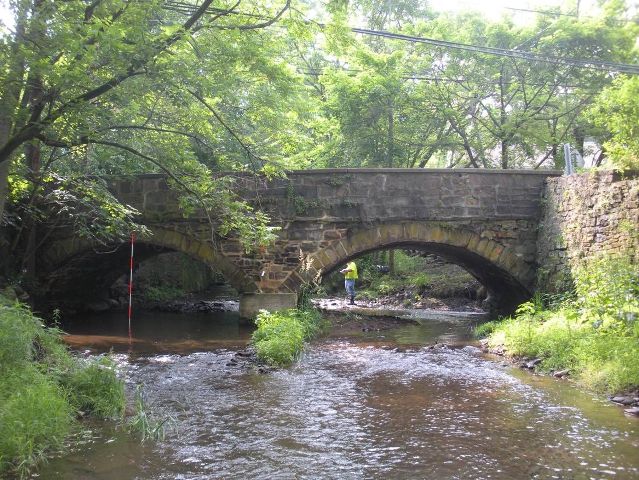
This bridge is an excellent example of a mid-19th century stone arch bridge in southeastern Pennsylvania. The bridge has few alterations and the historic integrity is good. A marble plaque on the bridge says simply "County Bridge 1854."
As of 2010, while PennDOT's overall historic bridge preservation commitment, particularly with metal truss bridges, is perhaps the poorest in the entire country, some credit is deserved for their choosing to rehabilitate a number of beautiful historic stone arch bridges in eastern Pennsylvania. It is hoped that PennDOT will see the feasibility and value of preserving these stone arch bridges and extend the commitment to a larger pool of stone arch bridges, as well as other historic bridge types such as concrete arch bridges and metal truss bridges.
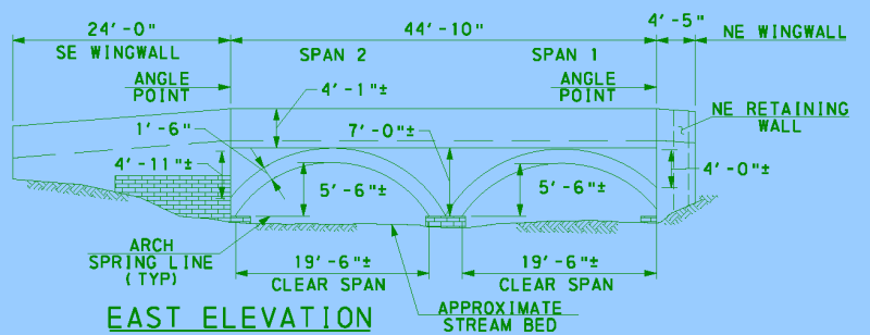
This bridge has been selected for preservation and rehabilitation by PennDOT. Transystems (owner of former company Lichtenstein, a firm with noted historic bridge rehabilitation experience) has been selected to design the rehabilitation projects. Credit is given to Transystems for the plans that the drawing on this page was adapted from, and the details of the rehabilitation as outlined by Transystems is shown below.
The Carver-Wismer Road over Paunnacussing Creek stone arch bridge is 2 spans and 45 feet long. The scope of rehabilitation includes reconstruction of stone masonry parapets with reinforced concrete cores and full width moment slab, reconstruction of wingwalls, and repointing as needed. In-stream work includes the placement of rip-rap around substructure units for scour protection and the installation of temporary arch-barrel supports. Temporary stream diversion may be required.
Information and Findings From Pennsylvania's Stone Arch Bridge Management PlanDiscussion of Bridge This bridge is a candidate for long-term preservation. It ranks in the upper third of all stone arch bridges under study in this plan. This bridge is in excellent condition, having been repointed in 2005. It handles its traffic reasonably well, but the transportation code is moderate because of a combination of high traffic volumes and a narrow roadway. However, the bridge lies in an area of low development potential, so future traffic growth is not likely to become a problem. Its waterway is adequate. The projected cost to rehabilitate the bridge is moderate, meaning that it will cost somewhat more to rehabilitate than similar bridges. The bridge has a high recreational, historical, and cultural values code. It is individually eligible for listing in the National Register of Historic Places, contributes to the Carversville Historic District, and is near a park. Public input was high (24 questionnaires, three letters, four emails, and one meeting at which this bridge was a focus). Ratings The Solebury, Aquetong Road Bridge is owned by
PennDOT and is ranked 31st. Recommendation: Recommended for long-term preservation. |
![]()
![]()
![]()
Coordinates (Latitude, Longitude):
Search For Additional Bridge Listings:
Bridgehunter.com: View listed bridges within 0.5 miles (0.8 kilometers) of this bridge.
Bridgehunter.com: View listed bridges within 10 miles (16 kilometers) of this bridge.
Additional Maps:
Google Streetview (If Available)
GeoHack (Additional Links and Coordinates)
Apple Maps (Via DuckDuckGo Search)
Apple Maps (Apple devices only)
Android: Open Location In Your Map or GPS App
Flickr Gallery (Find Nearby Photos)
Wikimedia Commons (Find Nearby Photos)
Directions Via Sygic For Android
Directions Via Sygic For iOS and Android Dolphin Browser
USGS National Map (United States Only)
Historical USGS Topo Maps (United States Only)
Historic Aerials (United States Only)
CalTopo Maps (United States Only)

© Copyright 2003-2024, HistoricBridges.org. All Rights Reserved. Disclaimer: HistoricBridges.org is a volunteer group of private citizens. HistoricBridges.org is NOT a government agency, does not represent or work with any governmental agencies, nor is it in any way associated with any government agency or any non-profit organization. While we strive for accuracy in our factual content, HistoricBridges.org offers no guarantee of accuracy. Information is provided "as is" without warranty of any kind, either expressed or implied. Information could include technical inaccuracies or errors of omission. Opinions and commentary are the opinions of the respective HistoricBridges.org member who made them and do not necessarily represent the views of anyone else, including any outside photographers whose images may appear on the page in which the commentary appears. HistoricBridges.org does not bear any responsibility for any consequences resulting from the use of this or any other HistoricBridges.org information. Owners and users of bridges have the responsibility of correctly following all applicable laws, rules, and regulations, regardless of any HistoricBridges.org information.
![]()