We Recommend:
Bach Steel - Experts at historic truss bridge restoration.
Edge Mill Road Bridge

Primary Photographer(s): Elaine Deutsch
Bridge Documented: 2008
Rural: Chester County, Pennsylvania: United States
1916 By Builder/Contractor: Dunleavy Brothers of Coatesville, Pennsylvania and Engineer/Design: Nathan R. Rambo
Not Available or Not Applicable
24.0 Feet (7.3 Meters)
74.2 Feet (22.6 Meters)
20.3 Feet (6.19 Meters)
3 Main Span(s)
15401500203422

View Information About HSR Ratings
Bridge Documentation
View Archived National Bridge Inventory Report - Has Additional Details and Evaluation
View The National Register of Historic Places Nomination Form For This Historic Bridge
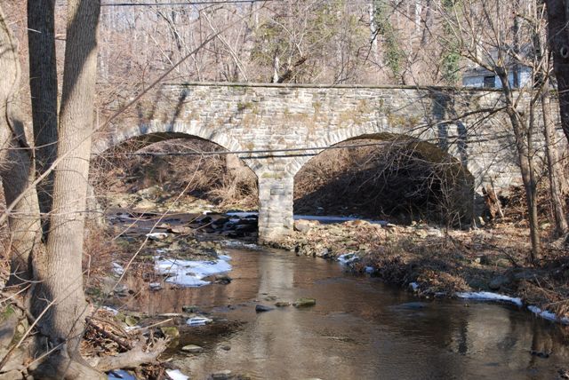
This bridge is one of a number of stone arch bridges in the county. It is noted for its arches which rest upon a taller pier than many of the arch bridges in the county.
Information and Findings From Pennsylvania's Historic Bridge InventoryDiscussion of Bridge The 3-span, 74'-long stone arch bridge built in 1916 is listed in the National Register. There has been no change in the bridge's status since the previous survey. Discussion of Surrounding Area The bridge carries a 2 lane road over a stream in a rural setting of scattered 19th-century residences and a mill. Bridge Considered Historic By Survey: Yes Information and Findings From Pennsylvania's Stone Arch Bridge Management PlanDiscussion of Bridge This bridge is recommended for long-term preservation. It ranks in the top third of all stone arch bridges under study in this plan. The bridge's character-defining historical features are largely intact, making its cost to rehabilitate relatively inexpensive. It lies in an area of low development potential, which will allow the bridge to carry its traffic into the future. It should be noted, however, that its transportation code is moderate, a function of the bridge's narrow roadway width and a center hump that restricts sight distance. The bridge has a high values code; it is listed in the National Register of Historic Places and it is part of a greenway. The bridge has received much public support (one letter, two telephone calls, and one meeting at which this bridge was a focus). Its waterway is adequate. However, the bridge's condition code is low due to exposed footers, which may result in scour. The bridge superstructure also has some cracks and loose stones. These conditions should be corrected using the procedures of the Maintenance Manual developed for this project. Ratings The Caln, Edge Mill Road Bridge is owned by PennDOT
and is ranked 22nd. Recommendation: Recommended for long-term preservation. |
![]()
Photo Galleries and Videos: Edge Mill Road Bridge
Bridge Photo-Documentation
Original / Full Size PhotosA collection of overview and detail photos. This gallery offers photos in the highest available resolution and file size in a touch-friendly popup viewer.
Alternatively, Browse Without Using Viewer
![]()
Bridge Photo-Documentation
Mobile Optimized PhotosA collection of overview and detail photos. This gallery features data-friendly, fast-loading photos in a touch-friendly popup viewer.
Alternatively, Browse Without Using Viewer
![]()
Maps and Links: Edge Mill Road Bridge
Coordinates (Latitude, Longitude):
Search For Additional Bridge Listings:
Bridgehunter.com: View listed bridges within 0.5 miles (0.8 kilometers) of this bridge.
Bridgehunter.com: View listed bridges within 10 miles (16 kilometers) of this bridge.
Additional Maps:
Google Streetview (If Available)
GeoHack (Additional Links and Coordinates)
Apple Maps (Via DuckDuckGo Search)
Apple Maps (Apple devices only)
Android: Open Location In Your Map or GPS App
Flickr Gallery (Find Nearby Photos)
Wikimedia Commons (Find Nearby Photos)
Directions Via Sygic For Android
Directions Via Sygic For iOS and Android Dolphin Browser
USGS National Map (United States Only)
Historical USGS Topo Maps (United States Only)
Historic Aerials (United States Only)
CalTopo Maps (United States Only)

