

View Information About HSR Ratings
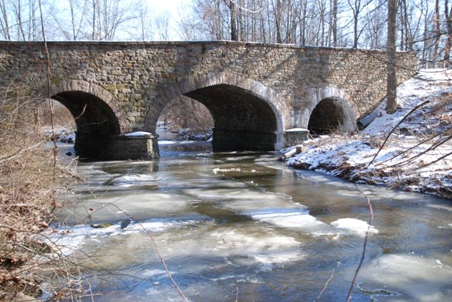
This bridge is a rare example of a stone arch bridge with an elliptical span, which on this bridge is the center span. A single segmental span is on either side. Chester County has a large collection of stone arch bridges, but most display segmental spans only. The bridge also stands out in the county as a 19th Century example. Chester County was unusual in that it has more early 20th Century stone arch bridges remaining, a result of the county sticking with stone when other counties were switching to metal or concrete for bridges.
Information and Findings From Pennsylvania's Historic Bridge InventoryDiscussion of Bridge The 3-span, 63'-long, stone arch bridge, built in 1888, has dressed voussoirs and fieldstone spandrel walls and parapets with stone coping. U-shaped wingwalls with parapets enclose the approaches. In 1995, the spandrel walls of the two end spans collapsed. The arch rings were repaired and the spandrel walls rebuilt with a concrete retaining wall inside of the spandrel walls for strengthening. The repair and repointing were sensitive to the historic appearance and have not adversely impacted the bridge's integrity of original design. The bridge is a complete, handsome, multiple span example of the traditional stone arch bridge type. It is one of only three identified 19th-century examples surviving in Chester County (the other two were built in 1804 and 1807). It documents an important bridge type that was favored throughout the 19th century wherever builders desired a permanent bridge. Discussion of Surrounding Area The bridge carries a 2 lane road over a stream in a rural setting of forested lots and open fields. No buildings are adjacent to the bridge. A note in the county inspection file states the bridge adjoins the Isabella Furnace historic site, but this information does not appear to be correct. The furnace ruins and manor house are located more than 1/2-mile to the north of the bridge. The furnace was listed in the National Register 9/6/91. The bridge is not adjacent to or within the boundaries of the listed furnace property. Henry Potts built the furnace in 1835. The furnace reached the zenith of its activity in the 1880s and closed in 1894. The wooded property adjacent to the bridge may at one time have been part of the larger iron furnace tract. Bridge Considered Historic By Survey: Yes Information and Findings From Pennsylvania's Stone Arch Bridge Management PlanDiscussion of Bridge This bridge is a strong candidate for long-term preservation. The bridge is one of the highest ranking of all stone arch bridges under study in this plan. It is rated as high or very high in all but one category. Its condition is excellent. Its transportation code is very high, a result of low traffic volume and good sight distance at the approaches. It stands in an area of low development potential, and should be able to carry its traffic well for some time. Its waterway adequacy is rated as high. The cost to rehabilitate is relatively low, as the bridge is largely intact. The bridge is individually eligible for listing in the National Register of Historic Places and stands in a park; it is locally and regionally important. The bridge has public support (one letter, three telephone calls, and one meeting at which this bridge was a focus). Ratings The West Nantmeal, Wyebrook Road Bridge is owned by
Chester County and is ranked 5th. Recommendation: A strong candidate for long-term preservation. |
![]()
![]()
![]()
Coordinates (Latitude, Longitude):
Search For Additional Bridge Listings:
Bridgehunter.com: View listed bridges within 0.5 miles (0.8 kilometers) of this bridge.
Bridgehunter.com: View listed bridges within 10 miles (16 kilometers) of this bridge.
Additional Maps:
Google Streetview (If Available)
GeoHack (Additional Links and Coordinates)
Apple Maps (Via DuckDuckGo Search)
Apple Maps (Apple devices only)
Android: Open Location In Your Map or GPS App
Flickr Gallery (Find Nearby Photos)
Wikimedia Commons (Find Nearby Photos)
Directions Via Sygic For Android
Directions Via Sygic For iOS and Android Dolphin Browser
USGS National Map (United States Only)
Historical USGS Topo Maps (United States Only)
Historic Aerials (United States Only)
CalTopo Maps (United States Only)

© Copyright 2003-2024, HistoricBridges.org. All Rights Reserved. Disclaimer: HistoricBridges.org is a volunteer group of private citizens. HistoricBridges.org is NOT a government agency, does not represent or work with any governmental agencies, nor is it in any way associated with any government agency or any non-profit organization. While we strive for accuracy in our factual content, HistoricBridges.org offers no guarantee of accuracy. Information is provided "as is" without warranty of any kind, either expressed or implied. Information could include technical inaccuracies or errors of omission. Opinions and commentary are the opinions of the respective HistoricBridges.org member who made them and do not necessarily represent the views of anyone else, including any outside photographers whose images may appear on the page in which the commentary appears. HistoricBridges.org does not bear any responsibility for any consequences resulting from the use of this or any other HistoricBridges.org information. Owners and users of bridges have the responsibility of correctly following all applicable laws, rules, and regulations, regardless of any HistoricBridges.org information.
![]()