

View Information About HSR Ratings
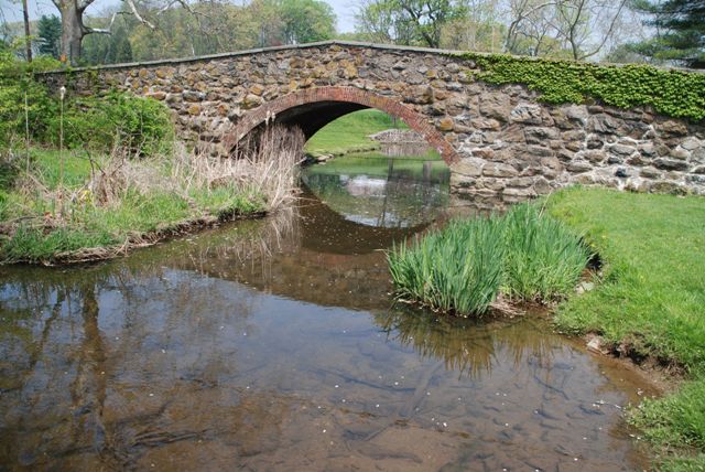
This is a small but beautiful example of Chester County's unique stone arch bridges that use brick for the arch ring. This bridge has excellent historic integrity.
Information and Findings From Pennsylvania's Historic Bridge InventoryDiscussion of Bridge The single span, 28'-long, brick arch bridge built in 1904 has fieldstone spandrel walls and parapets. It is supported on stone pier and abutments with U-shaped wingwalls and parapets enclosing the approach roadways. In Pennsylvania, the brick arch was never a widely popular bridge type, with over two-thirds of the 25 extant examples from 1864 to 1908 in the three southeastern counties of Chester, Delaware, and Philadelphia. A cluster of 9 examples in Chester County date from 1901 to 1908. Chester County has more brick arch bridges than any other county in the state. They were built under the supervision of Chester County Engineer Nathan R. Rambo, who favored masonry arches at a time when other county engineers were turning to reinforced concrete. The choice of brick arch bridges reflected as much a desire to build a bridge type that required little in the way of formal engineering design or calculations, as it did an aesthetic decision. The handsome brick arch bridges offered low maintenance costs and permanency. Complete and particularly well detailed examples are technologically significant in the county and regional contexts. Discussion of Surrounding Area The bridge carries a 2 lane road over a stream in a settiing of horse farms and estate houses with large lawns and pastures. Approximately 1000' east of the bridge is an early 20th century estate house with a long lawn overlooking the bridge. Approximately 1000' to the southwest is an early 19th century brick residence and farm complex. Bridge Considered Historic By Survey: Yes |
![]()
![]()
![]()
Coordinates (Latitude, Longitude):
Search For Additional Bridge Listings:
Bridgehunter.com: View listed bridges within 0.5 miles (0.8 kilometers) of this bridge.
Bridgehunter.com: View listed bridges within 10 miles (16 kilometers) of this bridge.
Additional Maps:
Google Streetview (If Available)
GeoHack (Additional Links and Coordinates)
Apple Maps (Via DuckDuckGo Search)
Apple Maps (Apple devices only)
Android: Open Location In Your Map or GPS App
Flickr Gallery (Find Nearby Photos)
Wikimedia Commons (Find Nearby Photos)
Directions Via Sygic For Android
Directions Via Sygic For iOS and Android Dolphin Browser
USGS National Map (United States Only)
Historical USGS Topo Maps (United States Only)
Historic Aerials (United States Only)
CalTopo Maps (United States Only)

© Copyright 2003-2024, HistoricBridges.org. All Rights Reserved. Disclaimer: HistoricBridges.org is a volunteer group of private citizens. HistoricBridges.org is NOT a government agency, does not represent or work with any governmental agencies, nor is it in any way associated with any government agency or any non-profit organization. While we strive for accuracy in our factual content, HistoricBridges.org offers no guarantee of accuracy. Information is provided "as is" without warranty of any kind, either expressed or implied. Information could include technical inaccuracies or errors of omission. Opinions and commentary are the opinions of the respective HistoricBridges.org member who made them and do not necessarily represent the views of anyone else, including any outside photographers whose images may appear on the page in which the commentary appears. HistoricBridges.org does not bear any responsibility for any consequences resulting from the use of this or any other HistoricBridges.org information. Owners and users of bridges have the responsibility of correctly following all applicable laws, rules, and regulations, regardless of any HistoricBridges.org information.
![]()