

View Information About HSR Ratings
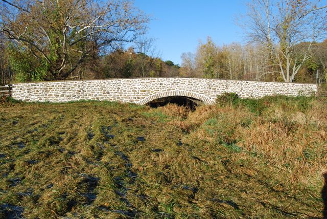
This is a small but beautiful stone arch bridge that unlike many of Chester County's stone arch bridges is located somewhat out in the open where it is easier to see. The bridge is also a contributing resource for a historic district.
Information and Findings From Pennsylvania's Historic Bridge InventoryDiscussion of Bridge The one-span, 31'-long, stone arch bridge, built in 1913, has dressed voussoirs and fieldstone spandrel walls and parapets. It is supported on stone abutments. U-shaped wingwalls with parapets enclose the approaches. The traditional stone arch bridge, while postdating the 18th- and 19th-century dates of construction of the furnace and majority of buildings associated with the farm complex, is in keeping with the undisturbed rural setting and conscious efforts during the 20th century of the Potts family and their heirs to maintain the 650-acre Warwick Furnace-Farm tract without signs of modern development. The bridge was not rated in the 1976 National Register nomination. It is evaluated a contributing resource. Discussion of Surrounding Area The bridge carries a 2 lane road over a stream in a rural area of active farms with cultivated fields to all quadrants. It is entirely inside the boundaries of the Warwick Furnace-Farms Complex, listed in the National Register (9/13/1976). The 18th- and 19th-century furnace ruins and manor buildings are located approximately 1/4-mile north of the bridge near the intersection of Valley Way and Warwick Furnace Road. The furnace, one of the first in Chester County, operated from ca. 1720-1867, and is historically significant in the early development of Pennsylvania's iron industry. After 1867, the site converted to a model scientific farm. In the 20th century, there has been an emphasis on maintaining the property's historic appearance with few visible modern buildings or developments. Bridge Considered Historic By Survey: Yes Information and Findings From Pennsylvania's Stone Arch Bridge Management PlanDiscussion of Bridge This bridge is an excellent candidate for long-term preservation. It is highly ranked among all stone arch bridges under study in this plan. The bridge is rated high or very high in four of seven categories. This bridge has a high condition code and does not require any specific action. Its transportation code is also very high, a result of low traffic volumes and good sight distances at the approaches. It stands in an area of low development potential, and should be able to carry its traffic for some time into the future. Its waterway is adequate. The cost to rehabilitate is low because the bridge's historic fabric is largely intact. The bridge contributes to a National Register of Historic Places historic district (Warwick Furnace-Farm, listed in 1976) and is locally and regionally important. The bridge, however, has received limited public support (one letter). Ratings The Warwick, Valley Way Bridge is owned by Chester
County and is ranked 15th. Recommendation: A strong candidate for long-term preservation. |
![]()
![]()
![]()
Coordinates (Latitude, Longitude):
Search For Additional Bridge Listings:
Bridgehunter.com: View listed bridges within 0.5 miles (0.8 kilometers) of this bridge.
Bridgehunter.com: View listed bridges within 10 miles (16 kilometers) of this bridge.
Additional Maps:
Google Streetview (If Available)
GeoHack (Additional Links and Coordinates)
Apple Maps (Via DuckDuckGo Search)
Apple Maps (Apple devices only)
Android: Open Location In Your Map or GPS App
Flickr Gallery (Find Nearby Photos)
Wikimedia Commons (Find Nearby Photos)
Directions Via Sygic For Android
Directions Via Sygic For iOS and Android Dolphin Browser
USGS National Map (United States Only)
Historical USGS Topo Maps (United States Only)
Historic Aerials (United States Only)
CalTopo Maps (United States Only)

© Copyright 2003-2024, HistoricBridges.org. All Rights Reserved. Disclaimer: HistoricBridges.org is a volunteer group of private citizens. HistoricBridges.org is NOT a government agency, does not represent or work with any governmental agencies, nor is it in any way associated with any government agency or any non-profit organization. While we strive for accuracy in our factual content, HistoricBridges.org offers no guarantee of accuracy. Information is provided "as is" without warranty of any kind, either expressed or implied. Information could include technical inaccuracies or errors of omission. Opinions and commentary are the opinions of the respective HistoricBridges.org member who made them and do not necessarily represent the views of anyone else, including any outside photographers whose images may appear on the page in which the commentary appears. HistoricBridges.org does not bear any responsibility for any consequences resulting from the use of this or any other HistoricBridges.org information. Owners and users of bridges have the responsibility of correctly following all applicable laws, rules, and regulations, regardless of any HistoricBridges.org information.
![]()