

View Information About HSR Ratings
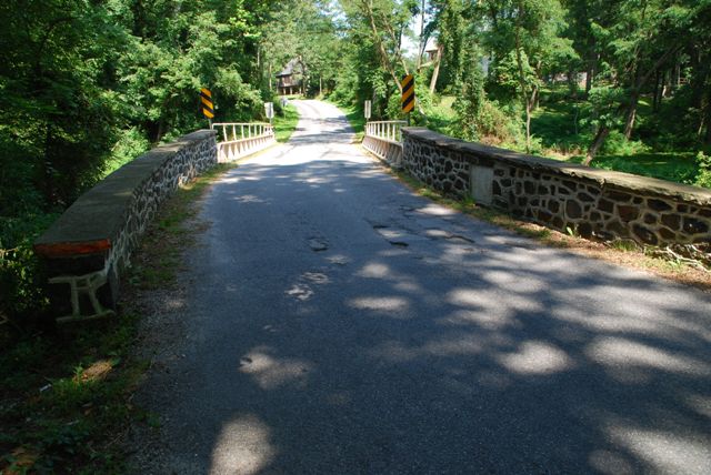
This bridge is one of several surviving plate girder highway bridges in Chester County. A number of these bridges, including this one, stand out for their use of handsome stone abutments, an interesting contrast to the simple riveted plate girder superstructure. Bridges like this one are among the more attractive examples of an otherwise generally utilitarian bridge type.
Information and Findings From Pennsylvania's Historic Bridge InventoryDiscussion of Bridge The single span, 54'-long, steel thru girder bridge built in 1914 is supported on stone abutments with wingwalls. The bridge has pipe railings attached to the top flanges of the girders. Stone parapets enclose the approaches. It is an example of a common type and design that has been in widespread use for railroad applications since the mid-19th century and for highway applications since at least 1900. It has no innovative or distinguishing details. Earlier and more distinguished examples have been identified in the county and state contexts. Based on its date of construction, the 1914 bridge does not have a significant historic association with the 19th-century farm that is located to its northwest. The bridge is not historically distinguished by its setting. Discussion of Surrounding Area The bridge carries a 2 lane road over a stream. All of the bridge's quadrants are wooded. Approximately 400' to the northwest is a vernacular stone farmhouse (ca. 1800) with barn. Although the farmstead appears to retain its 19th-century appearance, the surrounding area is dominated by late-20th-century subdivisions and does not have the character or cohesiveness of a potential rural historic district. Bridge Considered Historic By Survey: No |
![]()
![]()
![]()
Coordinates (Latitude, Longitude):
Search For Additional Bridge Listings:
Bridgehunter.com: View listed bridges within 0.5 miles (0.8 kilometers) of this bridge.
Bridgehunter.com: View listed bridges within 10 miles (16 kilometers) of this bridge.
Additional Maps:
Google Streetview (If Available)
GeoHack (Additional Links and Coordinates)
Apple Maps (Via DuckDuckGo Search)
Apple Maps (Apple devices only)
Android: Open Location In Your Map or GPS App
Flickr Gallery (Find Nearby Photos)
Wikimedia Commons (Find Nearby Photos)
Directions Via Sygic For Android
Directions Via Sygic For iOS and Android Dolphin Browser
USGS National Map (United States Only)
Historical USGS Topo Maps (United States Only)
Historic Aerials (United States Only)
CalTopo Maps (United States Only)

© Copyright 2003-2024, HistoricBridges.org. All Rights Reserved. Disclaimer: HistoricBridges.org is a volunteer group of private citizens. HistoricBridges.org is NOT a government agency, does not represent or work with any governmental agencies, nor is it in any way associated with any government agency or any non-profit organization. While we strive for accuracy in our factual content, HistoricBridges.org offers no guarantee of accuracy. Information is provided "as is" without warranty of any kind, either expressed or implied. Information could include technical inaccuracies or errors of omission. Opinions and commentary are the opinions of the respective HistoricBridges.org member who made them and do not necessarily represent the views of anyone else, including any outside photographers whose images may appear on the page in which the commentary appears. HistoricBridges.org does not bear any responsibility for any consequences resulting from the use of this or any other HistoricBridges.org information. Owners and users of bridges have the responsibility of correctly following all applicable laws, rules, and regulations, regardless of any HistoricBridges.org information.
![]()