

View Information About HSR Ratings
This traditionally composed stone arch has had a small approach span added to it in 1981. The new span is a pre-stressed concrete box beam structure.
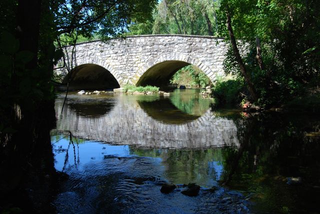
Information and Findings From Pennsylvania's Historic Bridge InventoryDiscussion of Bridge The bridge consists of a 2-span stone arch bridge, built in 1919, and a prestressed concrete box beam overflow approach bridge, built in 1981. The stone arch spans have dressed voussoirs, and fieldstone spandrel walls and parapets. They are supported on stone abutments and pier with concrete scour protection added. The arch bridge was repointed in 1981, and the north wingwalls rebuilt to match the profile of the adjacent prestressed concrete box beam overflow bridge. The overflow span was faced with stone to match the arch bridge. The alteration, while sensitive, has resulted in a significant change in the bridge's historic appearance. The stone arch bridge is an altered example of a bridge type that is common from the first two decades of the 20th century in Chester County. The county-built traditional stone arch bridges were favored by the county engineer, and at least 19 similar bridges from 1908 to 1919 have been identified. Stone arch bridges have been in use in Pennsylvania since the late 17th century, and over 350 examples have been identified statewide, with more than two-thirds dating to before 1900. Early 20th century examples in Chester County are considered individually significant in the local context only when they are complete and large or particularly well detailed. This altered example is not historically or technologically distinguished within its population or by its setting and context. Discussion of Surrounding Area The bridge carries a 2 lane road with shoulders over a stream in an area dominated by midto late-20th century residential development. The setting does not have historic district potential. Bridge Considered Historic By Survey: No Information and Findings From Pennsylvania's Stone Arch Bridge Management PlanDiscussion of Bridge This bridge is a moderate candidate for long-term preservation, but it has some factors that will need to be addressed. It lies within an area of rapid development. As a result, it may not be able to carry future traffic efficiently, especially since the bridge has a roadway width of less than 18 ft. However, this bridge has a very high condition code and needs no specific action at this time. Its transportation code is high, a result of relatively low traffic and good sight distance at the approaches. Its waterway is adequate, a result of an additional channel that has been cut at one end of the bridge (although spanned by a concrete slab). Its cost to rehabilitate is moderate, meaning that it would be moderately expensive to rehabilitate its historic form and fabric, particularly because of the concrete slab span. It is not listed in or eligible for listing in the National Register of Historic Places individually or as part of a historic district, and it is not part of a park, natural area, or greenway. Public support has been moderate. Ratings The Caln, Lloyd Avenue Bridge is owned by Chester
County and is ranked 71st. Recommendation: A moderate candidate for long-term preservation. |
![]()
![]()
![]()
Coordinates (Latitude, Longitude):
Search For Additional Bridge Listings:
Bridgehunter.com: View listed bridges within 0.5 miles (0.8 kilometers) of this bridge.
Bridgehunter.com: View listed bridges within 10 miles (16 kilometers) of this bridge.
Additional Maps:
Google Streetview (If Available)
GeoHack (Additional Links and Coordinates)
Apple Maps (Via DuckDuckGo Search)
Apple Maps (Apple devices only)
Android: Open Location In Your Map or GPS App
Flickr Gallery (Find Nearby Photos)
Wikimedia Commons (Find Nearby Photos)
Directions Via Sygic For Android
Directions Via Sygic For iOS and Android Dolphin Browser
USGS National Map (United States Only)
Historical USGS Topo Maps (United States Only)
Historic Aerials (United States Only)
CalTopo Maps (United States Only)

© Copyright 2003-2024, HistoricBridges.org. All Rights Reserved. Disclaimer: HistoricBridges.org is a volunteer group of private citizens. HistoricBridges.org is NOT a government agency, does not represent or work with any governmental agencies, nor is it in any way associated with any government agency or any non-profit organization. While we strive for accuracy in our factual content, HistoricBridges.org offers no guarantee of accuracy. Information is provided "as is" without warranty of any kind, either expressed or implied. Information could include technical inaccuracies or errors of omission. Opinions and commentary are the opinions of the respective HistoricBridges.org member who made them and do not necessarily represent the views of anyone else, including any outside photographers whose images may appear on the page in which the commentary appears. HistoricBridges.org does not bear any responsibility for any consequences resulting from the use of this or any other HistoricBridges.org information. Owners and users of bridges have the responsibility of correctly following all applicable laws, rules, and regulations, regardless of any HistoricBridges.org information.
![]()