

View Information About HSR Ratings
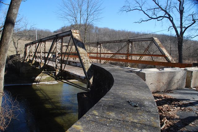
For a half-hip variety of pony truss bridge, this is a fairly long span example at 74 feet and five panels. The bridge plaque has gone missing (although a plaque for the abutments remains) but the Historic Bridge Inventory apparently learned that Nelson and Buchanan of Chambersburg, Pennsylvania built the bridge. The bridge has been closed to traffic, but retains good historic integrity. It would be feasible to rehabilitate if the interest was there to do so.
Information and Findings From Pennsylvania's Historic Bridge InventoryDiscussion of Bridge The 74' long and 16' wide, pin-connected Pratt pony truss bridge built for the county in 1896 is supported on concrete-coated stone abutments with flared wingwalls. The trusses with the built up floor beams above the lower chords are traditionally composed, and the outriggers are original. The design is typical of its fabricator, Nelson and Buchanan of Chambersburg. Although the design is common throughout the state, this example is complete, documented, and earlier than most others. It is historically and technologically significant. Discussion of Surrounding Area The bridge carries one lane of an unimproved road over a stream in an agricultural and forested area with mid-19th century farms to the south and scattered modern housing to the north. Bridge Considered Historic By Survey: Yes |
![]()
![]()
![]()
This historic bridge has been demolished. This map is shown for reference purposes only.
Coordinates (Latitude, Longitude):
Search For Additional Bridge Listings:
Bridgehunter.com: View listed bridges within 0.5 miles (0.8 kilometers) of this bridge.
Bridgehunter.com: View listed bridges within 10 miles (16 kilometers) of this bridge.
Additional Maps:
Google Streetview (If Available)
GeoHack (Additional Links and Coordinates)
Apple Maps (Via DuckDuckGo Search)
Apple Maps (Apple devices only)
Android: Open Location In Your Map or GPS App
Flickr Gallery (Find Nearby Photos)
Wikimedia Commons (Find Nearby Photos)
Directions Via Sygic For Android
Directions Via Sygic For iOS and Android Dolphin Browser
USGS National Map (United States Only)
Historical USGS Topo Maps (United States Only)
Historic Aerials (United States Only)
CalTopo Maps (United States Only)

© Copyright 2003-2024, HistoricBridges.org. All Rights Reserved. Disclaimer: HistoricBridges.org is a volunteer group of private citizens. HistoricBridges.org is NOT a government agency, does not represent or work with any governmental agencies, nor is it in any way associated with any government agency or any non-profit organization. While we strive for accuracy in our factual content, HistoricBridges.org offers no guarantee of accuracy. Information is provided "as is" without warranty of any kind, either expressed or implied. Information could include technical inaccuracies or errors of omission. Opinions and commentary are the opinions of the respective HistoricBridges.org member who made them and do not necessarily represent the views of anyone else, including any outside photographers whose images may appear on the page in which the commentary appears. HistoricBridges.org does not bear any responsibility for any consequences resulting from the use of this or any other HistoricBridges.org information. Owners and users of bridges have the responsibility of correctly following all applicable laws, rules, and regulations, regardless of any HistoricBridges.org information.
![]()