

View Information About HSR Ratings
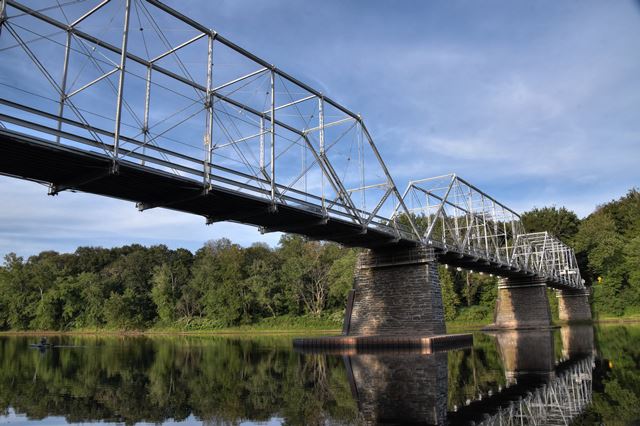
This extremely rare Phoenix column Baltimore truss is also unusual because it is a privately owned toll highway bridge. Please note this bridge is private property. The owners of the bridge refused a request from HistoricBridges.org to walk on the bridge to conduct a full photo-documentation so all photos are taken from off of the bridge. The bridge was built ca 1890 at Laceyville, Pennsylvania and moved here in 1900.
Information and Findings From New Jersey's Historic Bridge InventorySummary The 3-span Baltimore thru truss bridge supported on a masonry substructure has 2-rail metal railings. The bridge has minor alterations to the truss diagonal members. The span is technologically significant because it is a well-preserved example of an unusual truss design and for its use of patented Phoenix columns and connecting pieces. The span is located at an important crossing in an area settled in 1735. It is privately owned is operated under the original bridge company charter of 1834. Setting/Context The privately-owned bridge carries a 1-lane 2-way collector road over a major river forming the border between New Jersey and Pennsylvania. The area was settled by Andrew Dingman in 1735, and he operated a ferry here until the first bridge was constructed by the Dingman's Choice and Delaware Bridge Company, chartered in 1834. According to company sources, the present truss bridge was originally erected at Laceyville, PA (c.1890) and moved to the site in 1900. Bridge Considered Historic By Survey: Yes |
![]()
![]()
![]()
Coordinates (Latitude, Longitude):
Search For Additional Bridge Listings:
Bridgehunter.com: View listed bridges within 0.5 miles (0.8 kilometers) of this bridge.
Bridgehunter.com: View listed bridges within 10 miles (16 kilometers) of this bridge.
Additional Maps:
Google Streetview (If Available)
GeoHack (Additional Links and Coordinates)
Apple Maps (Via DuckDuckGo Search)
Apple Maps (Apple devices only)
Android: Open Location In Your Map or GPS App
Flickr Gallery (Find Nearby Photos)
Wikimedia Commons (Find Nearby Photos)
Directions Via Sygic For Android
Directions Via Sygic For iOS and Android Dolphin Browser
USGS National Map (United States Only)
Historical USGS Topo Maps (United States Only)
Historic Aerials (United States Only)
CalTopo Maps (United States Only)

© Copyright 2003-2025, HistoricBridges.org. All Rights Reserved. Disclaimer: HistoricBridges.org is a volunteer group of private citizens. HistoricBridges.org is NOT a government agency, does not represent or work with any governmental agencies, nor is it in any way associated with any government agency or any non-profit organization. While we strive for accuracy in our factual content, HistoricBridges.org offers no guarantee of accuracy. Information is provided "as is" without warranty of any kind, either expressed or implied. Information could include technical inaccuracies or errors of omission. Opinions and commentary are the opinions of the respective HistoricBridges.org member who made them and do not necessarily represent the views of anyone else, including any outside photographers whose images may appear on the page in which the commentary appears. HistoricBridges.org does not bear any responsibility for any consequences resulting from the use of this or any other HistoricBridges.org information. Owners and users of bridges have the responsibility of correctly following all applicable laws, rules, and regulations, regardless of any HistoricBridges.org information.
![]()