We Recommend:
Bach Steel - Experts at historic truss bridge restoration.
Fink Truss Bridge
Main Street Bridge

Primary Photographer(s): Elaine Deutsch
Bridge Documented: November 12, 2011
Rural: Chester County, Pennsylvania: United States
1991
43.2 Feet (13.2 Meters)
Not Available
Not Available
1 Main Span(s)
15701501880185

View Information About HSR Ratings
Bridge Documentation
View Historic American Engineering Record (HAER) Documentation For This Bridge
HAER Drawings, PDF
This is the only Fink truss in the entire Commonwealth of Pennsylvania. The Fink truss was one of the most popular truss designed used in the first iron railroad bridges built in the United States. They most commonly were deck trusses, but came in through truss format as well. The Fink truss's use quickly died out and extant examples were also rapid demolished when increased railroad loads rendered these early bridges highly insufficient and obsolete. Only a few examples remain nationwide today.
The interpretive signage next to the bridge states incorrectly regarding the Fink truss: "It is still the most widely used truss design in bridge building today." It is unclear where this statement came from since nothing could be further from the truth. The Fink truss quickly died out by the 1880s when the Pratt truss and later the Warren truss became the dominant truss configurations.
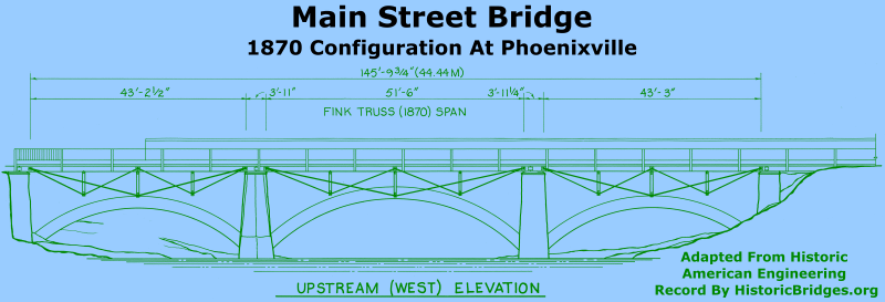
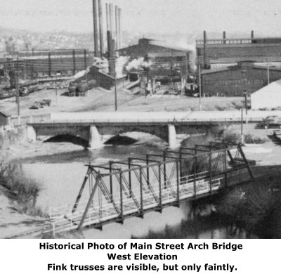
This bridge today sits preserved in a park setting as a non-functional exhibit. The history and original use of the bridge is unusual since it was built to essentially widen a stone arch bridge in Phoenixville, with the trusses supporting a sidewalk. One truss line was added alongside each of the three spans of the stone arch. When the bridge was relocated here, two of the truss spans were placed parallel to each other to form a more traditional independent two-truss structure. It is not known what happened to the third truss line.
Information and Findings From Pennsylvania's Historic Bridge InventoryDiscussion of Bridge According to Chester County records, the bridge was built in 1991. The 2 span prestressed concrete box beam bridge replaced a stone arch bridge constructed in 1847. Two Fink deck trusses were added to the stone arch bridge in 1870 to support a sidewalk. The rare Fink trusses were relocated to a pedestrian trail in Warwick Park, Warwick Twp., Chester County in 1991. The box beam bridge is in the Phoenixville Historic District, and due to its date of construction is a noncontributing structure. Bridge Considered Historic By Survey: Yes |
![]()
Photo Galleries and Videos: Fink Truss Bridge
Bridge Photo-Documentation
Original / Full Size PhotosA collection of overview and detail photos. This gallery offers photos in the highest available resolution and file size in a touch-friendly popup viewer.
Alternatively, Browse Without Using Viewer
![]()
Bridge Photo-Documentation
Mobile Optimized PhotosA collection of overview and detail photos. This gallery features data-friendly, fast-loading photos in a touch-friendly popup viewer.
Alternatively, Browse Without Using Viewer
![]()
Maps and Links: Fink Truss Bridge
Coordinates (Latitude, Longitude):
Search For Additional Bridge Listings:
Bridgehunter.com: View listed bridges within 0.5 miles (0.8 kilometers) of this bridge.
Bridgehunter.com: View listed bridges within 10 miles (16 kilometers) of this bridge.
Additional Maps:
Google Streetview (If Available)
GeoHack (Additional Links and Coordinates)
Apple Maps (Via DuckDuckGo Search)
Apple Maps (Apple devices only)
Android: Open Location In Your Map or GPS App
Flickr Gallery (Find Nearby Photos)
Wikimedia Commons (Find Nearby Photos)
Directions Via Sygic For Android
Directions Via Sygic For iOS and Android Dolphin Browser
USGS National Map (United States Only)
Historical USGS Topo Maps (United States Only)
Historic Aerials (United States Only)
CalTopo Maps (United States Only)


