

View Information About HSR Ratings
Maps, databases, and aerial imagery all show that this bridge crosses a barge basin, which is a short dead-end section of water for barges to enter. However, the plaque on this bridge says that the bridge crosses Deer Creek, which is actually less than a mile east of this bridge. It is unclear why this is shown on the plaque.
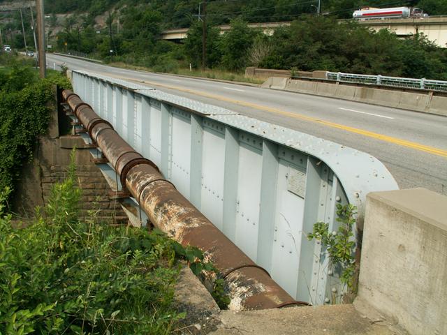
This bridge is a typical and representative example of a structure type that Pennsylvania once built with frequency on its highways, the through plate girder. This is unlike other states such as Michigan, which hardly ever built plate girders on its highways. The bridge has modern New Jersey barriers added for vehicular traffic, but otherwise retains excellent historic integrity, including pedestrian and abutment railings and plaques. The abutments are concrete, but framed within them is the smaller stone abutment of a previous bridge at this location.
Information and Findings From Pennsylvania's Historic Bridge InventoryDiscussion of Bridge The 1928, skewed, single span, built up thru girder bridge is supported on concrete abutments. The girder bridge has steel I beam floorbeams and a concrete deck. The bridge is an example of a common type with no innovative or distinguishing detail. Thru girder bridges were first developed by the railroad industry in the 1850s, and they were used on vehicular roadways in Allegheny County beginning in the late 19th century. The bridge is neither historically or technologically noteworthy. Discussion of Surrounding Area The bridge carries a 2 lane road and 2 sidewalks over a basin for barges at a bend in the Allegheny River near Twelvemile Island. Bridge Considered Historic By Survey: No |
![]()
![]()
Coordinates (Latitude, Longitude):
Search For Additional Bridge Listings:
Bridgehunter.com: View listed bridges within 0.5 miles (0.8 kilometers) of this bridge.
Bridgehunter.com: View listed bridges within 10 miles (16 kilometers) of this bridge.
Additional Maps:
Google Streetview (If Available)
GeoHack (Additional Links and Coordinates)
Apple Maps (Via DuckDuckGo Search)
Apple Maps (Apple devices only)
Android: Open Location In Your Map or GPS App
Flickr Gallery (Find Nearby Photos)
Wikimedia Commons (Find Nearby Photos)
Directions Via Sygic For Android
Directions Via Sygic For iOS and Android Dolphin Browser
USGS National Map (United States Only)
Historical USGS Topo Maps (United States Only)
Historic Aerials (United States Only)
CalTopo Maps (United States Only)

© Copyright 2003-2024, HistoricBridges.org. All Rights Reserved. Disclaimer: HistoricBridges.org is a volunteer group of private citizens. HistoricBridges.org is NOT a government agency, does not represent or work with any governmental agencies, nor is it in any way associated with any government agency or any non-profit organization. While we strive for accuracy in our factual content, HistoricBridges.org offers no guarantee of accuracy. Information is provided "as is" without warranty of any kind, either expressed or implied. Information could include technical inaccuracies or errors of omission. Opinions and commentary are the opinions of the respective HistoricBridges.org member who made them and do not necessarily represent the views of anyone else, including any outside photographers whose images may appear on the page in which the commentary appears. HistoricBridges.org does not bear any responsibility for any consequences resulting from the use of this or any other HistoricBridges.org information. Owners and users of bridges have the responsibility of correctly following all applicable laws, rules, and regulations, regardless of any HistoricBridges.org information.
![]()