

View Information About HSR Ratings
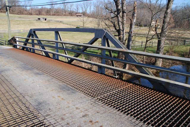
This bridge is a very early example of a welded truss bridge. Welded truss bridges were generally not common until the second half of the 20th Century and they are one of the few types of truss bridges still built today. This early example is significant because of its age. Also, it is of interest because it was designed and built completely by internal county forces. No outside engineer, contractor, or fabricator was hired to build the bridge.
Information and Findings From Pennsylvania's Historic Bridge InventoryDiscussion of Bridge The one-span, 43'-long, welded pony truss bridge built in 1933 is composed of rolled steel sections. It is supported on a concrete abutment at its south end, and a stone abutment at its north end. Bearings and concrete bridge seats were replaced in 1993. At the same time, an open steel grid deck and tubular metal railings were placed. The 1933 bridge is entirely within the boundaries and dates from the 1700-1940 period of significance of the Okehocking Indian Land Grant HD. According to county records, the welded steel Pratt truss was designed by the county engineer and fabricated by county maintenance forces. Welded connections were developed and first applied to structural steel in the late 1910s. Primarily used for steel-frame buildings, welding was also used in a limited fashion for truss highway bridges beginning in the late 1920s. The county engineer reported that he built several welded truss bridges as an expedient during the 1930s using the county's maintenance crews, a welding kit, and stock structural steel shapes. The bridges were simple, economical, and did not require the services of an outside contractor. An example of a bridge type and design used during the Depression by the county, the bridge is historically related to changes in the agricultural landscape during the final decade of the district's period of significance. Although not rated in the district's 1993 nomination, the bridge is evaluated as a contributing resource. Discussion of Surrounding Area The bridge carries a 2 lane road over a stream in the Okehocking Indian Land Grant HD. The district comprises a relatively undeveloped rural area in southern Willistown Twp. The dates of significance are from 1700 to 1940. The district is significant for the many well preserved vernacular buildings and farmsteads. Bridge Considered Historic By Survey: Yes |
![]()
![]()
![]()
Coordinates (Latitude, Longitude):
Search For Additional Bridge Listings:
Bridgehunter.com: View listed bridges within 0.5 miles (0.8 kilometers) of this bridge.
Bridgehunter.com: View listed bridges within 10 miles (16 kilometers) of this bridge.
Additional Maps:
Google Streetview (If Available)
GeoHack (Additional Links and Coordinates)
Apple Maps (Via DuckDuckGo Search)
Apple Maps (Apple devices only)
Android: Open Location In Your Map or GPS App
Flickr Gallery (Find Nearby Photos)
Wikimedia Commons (Find Nearby Photos)
Directions Via Sygic For Android
Directions Via Sygic For iOS and Android Dolphin Browser
USGS National Map (United States Only)
Historical USGS Topo Maps (United States Only)
Historic Aerials (United States Only)
CalTopo Maps (United States Only)

© Copyright 2003-2024, HistoricBridges.org. All Rights Reserved. Disclaimer: HistoricBridges.org is a volunteer group of private citizens. HistoricBridges.org is NOT a government agency, does not represent or work with any governmental agencies, nor is it in any way associated with any government agency or any non-profit organization. While we strive for accuracy in our factual content, HistoricBridges.org offers no guarantee of accuracy. Information is provided "as is" without warranty of any kind, either expressed or implied. Information could include technical inaccuracies or errors of omission. Opinions and commentary are the opinions of the respective HistoricBridges.org member who made them and do not necessarily represent the views of anyone else, including any outside photographers whose images may appear on the page in which the commentary appears. HistoricBridges.org does not bear any responsibility for any consequences resulting from the use of this or any other HistoricBridges.org information. Owners and users of bridges have the responsibility of correctly following all applicable laws, rules, and regulations, regardless of any HistoricBridges.org information.
![]()