

View Information About HSR Ratings
This bridge today serves highway traffic for a sewer plant. As such, it is not listed on the National Bridge Inventory.
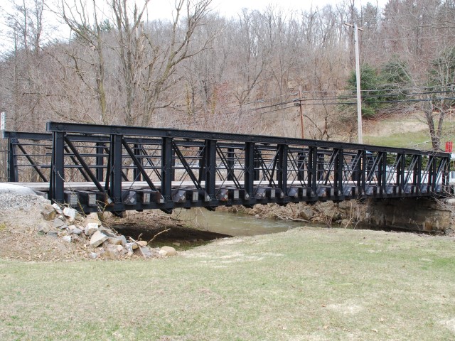
This bridge is without question among the more unusual and unique surviving metal truss bridges in Pennsylvania. Combined with observations of the bridge's design and construction details, along with information from the Glen Rock Historical and Preservation Society (their information included in its own section below) HistoricBridges.org has high confidence in stating that this appears to be a very early surviving example of a metal railroad truss bridge, and that it has a high amount of historical and technological significance representing the earlier development of the metal truss bridge in America. Metal railroad bridges from this era were nearly all replaced due to increasing loads that look place by the early 1900s.
This bridge has unusual design details, which is typical of early metal truss bridges and suggests that this is a very old bridge. Typical of railroad bridges, the members are very heavy, and there are numerous eyebars composing the bottom chord, as opposed to the typical two eyebars in each bottom chord which was typical for highway truss bridges of this length.
Other unusual details on the bridge include the following.
The bridge has thirteen panels, which is a very large number of panels for a truss bridge that is only a 74 foot span. This is further evidence of an old truss bridge, as are the uncommon use of vertical end posts.
The diagonal members are not typical eye "bars", but rather eye "rods" which at the tops are flattened out and shaped to form eyes. As such, tyhe top chord is pin-connected. However, connections on this bridge's are a threaded rod with nut design, so here the rods are not flattened out and instead just threaded. The diameter of the rods is greater at the ends of the truss indicating both understanding by the bridge's designer of how forces are distributed in a truss, as well as a desire for economy of materials.
Vertical members are back-to-back channels, but instead of a repeating pattern of lattice or lacing between them (as would be typical for a built-up beam of this design), only a single "X" of bars is present at the midpoint.
The bridge has pipe railings which are very old, but may not be original. Assuming the bridge was originally a railroad bridge, the pipes were probably added when it was turned into a highway bridge.
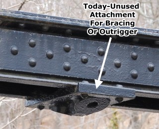
On the underside of the top chord in the middle of panels there are today-unused attachments designed to have a rod bolted to them. This suggests that the bridge has been altered, these attachments appear to have been intended for outriggers or bracing of some type.
The below information was provided by Pete Walters, Chairman of the Glen Rock Historical and Preservation Society, who also shared the historical photos included on this narrative.
I dug around a bit and even went down to bridge and looked over it for a plate with the builder, etc. on it and found nothing visible. The Baltimore & Susquehanna Railroad maiden run from Baltimore north into Pennsylvania was in 1838. The line became the Northern Central in 1854. In 1874, the N.C.R. bought the building in Glen Rock that housed the train station. In 1884, the N.C.R. built cattle pens beside the station, where they remained until 1907, despite repeated protests that the center of town was no place for cattle pens. Because of the protests, the N.C.R. built a stock yard / heavy freight siding just to the north of town.
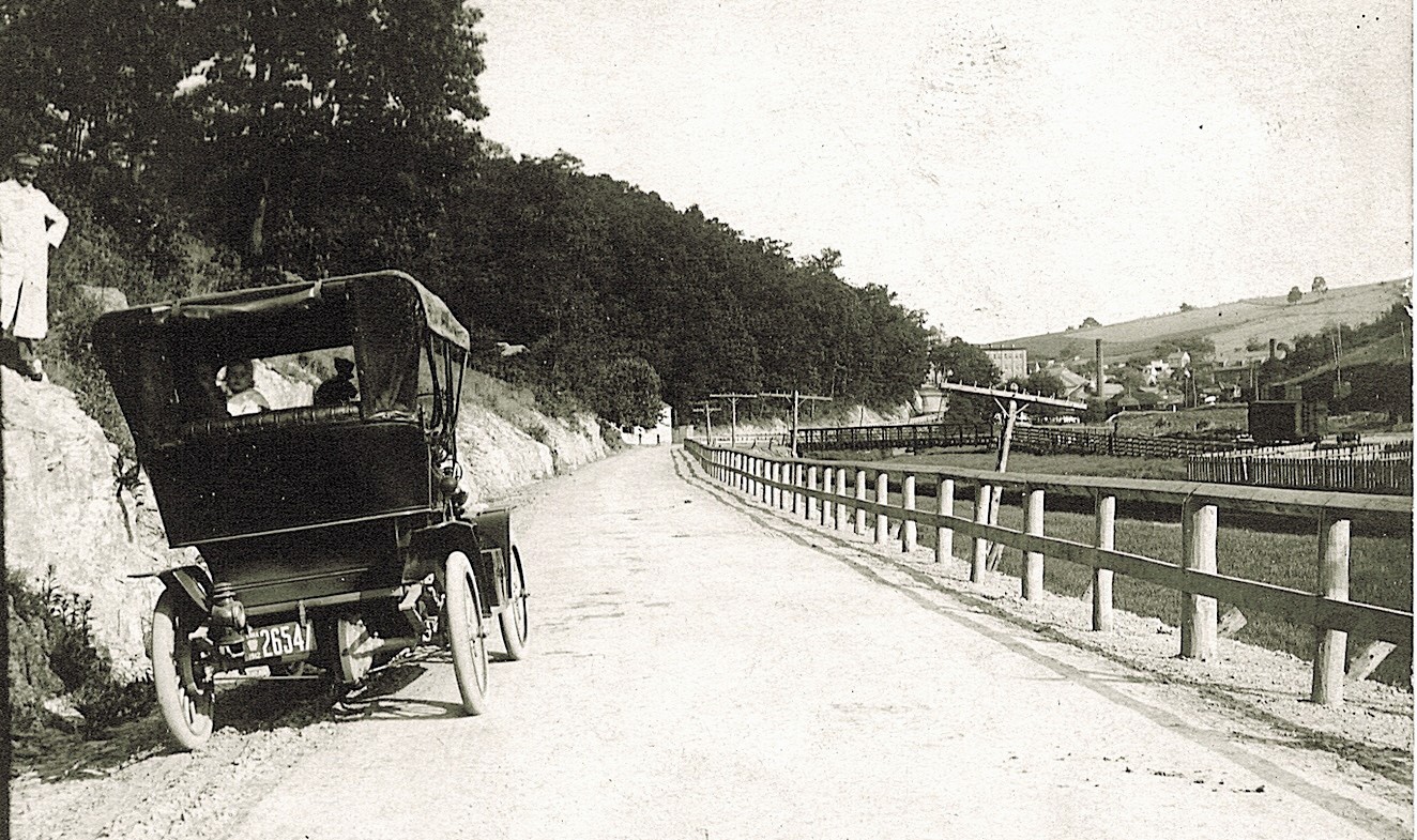
Picture above is interesting. If you blow it up on the screen, the license plate on the car appears to be 1912? Then, if you keep the picture enlarged and look at the right side, you see the bridge, a railcar on a siding and stock yards. I would venture a guess that the N.C.R. built these cattle pens north of town sometime in early 1907, just before, or shortly after they removed the pens in town at the station. Thus the time when the bridge most likely would have been placed here and why? The railroad tracks are about 125 - 150 feet behind the person that took the picture you sent to me to see. So, did the N.C.R. haul the bridge to this location in one piece on a flat car and then drag it to its resting place by horse or mules, or did it come in pieces by rail, drug across and assembled where it is? I am leaning towards the bridge was brought in from someplace, instead of having it built just for here because a heavy duty bridge like this would not have been necessary just to access the siding?

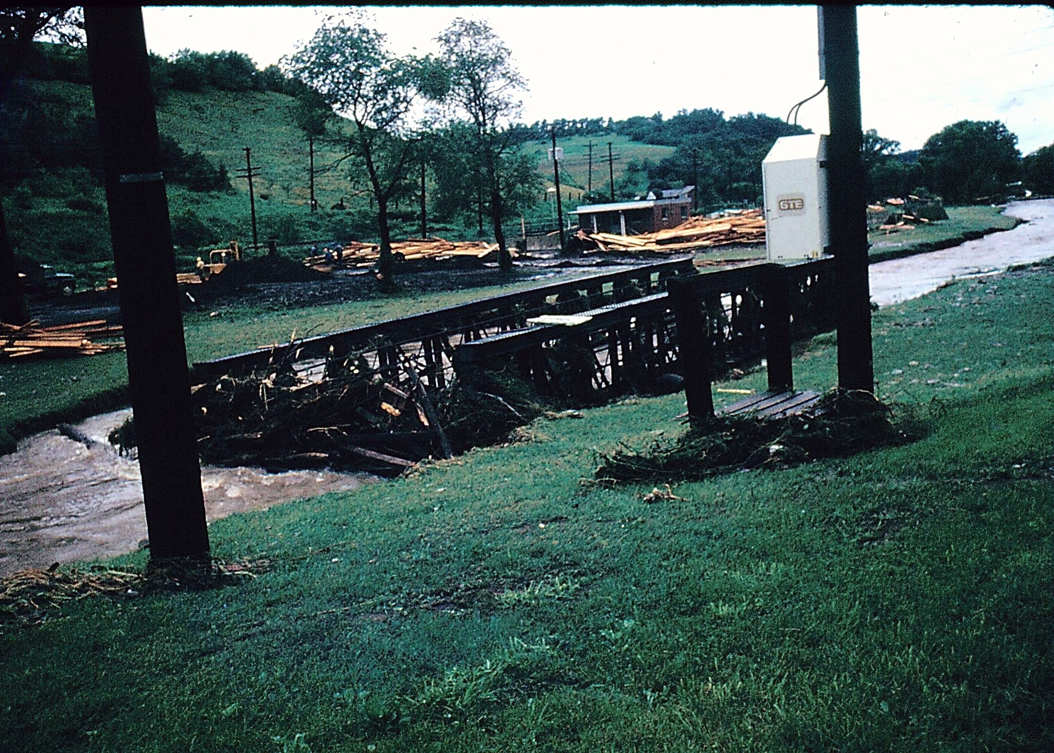
Picture above is another early view from probably the early teens. Before the sewer plant was built just beyond the bridge, the bridge was just used as an entrance for the lumber yard located just before the bridge. Pictures below from 1972 show the wrath and strength of hurricane Agnes as the bridge was picked up and turned sideways by the force of the water. The bridge was reinstalled after Agnes.

The following paragraph was sent to me from Michael Schmidt, a
former employee of the Glen Rock Water & Sewer Authority and is general info
that he has heard while working for them.
I was once told that the
bridge was "Left over". I have no idea how you come up with an "extra" bridge.
It was put there to access the stock yard and siding that was on the site of the
present sewer plant. There was a plate on it but it has been pitched over so
many times it is unreadable. In the mid 80's we had it inspected to see if it
was worth redecking. An old polish guy named Kisky or something came out and was
overwhelmed by it. Read with heavy polish accent .. "In all my days I have never
seen such a structure" The thing was designed for steam engines but our
Authority engineer at the time was concerned about it holding up a pick up
truck. Go down and look at it, I learned a lot about bridges form ole' Kisky.
Take note that the diagonal struts progress from big to little going to center,
then little to big towards the other end. Once the load met center point it
transferred the load to the opposite side. They must have had one hell of a
socket set, some of the nuts are over 4 inches across. In my 29+ years there we
redecked it 3 times. I also know that it took 2 cranes to pick it up and set it
back after Agnes picked it up and turned it sideways.


After all this, I still am unable to tell you when the bridge in question was built, where it was built or by whom. The newspaper article I requested shed no light on the bridge, it just spoke of the siding. The bridge has been maintained by the Glen Rock Water & Sewer Authority since 1965 when they built the sewage treatment plant just below the bridge. The roughly 9 x 13 wooden cross beams that support the wooden decking appear to be in very good (almost new) shape. The bridge was closed a few years ago, but that may have been to redeck it as that wood looks fairly new also. No one around here pays much attention to the bridge. It has been there, and it is used to get from one side of the creek to the other side. Until you expressed an interest, it was just an old bridge convenient for the sewer authority to use to get in and out of their facility, and that is the reason it is still in good shape.
Between 1861 and 1865 the N.C.R. double tracked the line from Baltimore north into Pennsylvania. The bridge appears to have been built for a single track line. So, was it built and used prior to 1861, or just used elsewhere and held by the N.C.R. so they had a spare bridge sitting around until they needed it? Or was it used on a single line elsewhere and hauled into Glen Rock, which was a double track for more than 40 years by 1907? The siding was used for more than the shipping in and out of cattle, horses and mules. The distillery which was located about a mile to the east of the siding would get car loads of grain shipped in and then the employees would haul the grain by wagon to the distillery.
![]()
![]()
![]()
Coordinates (Latitude, Longitude):
Search For Additional Bridge Listings:
Bridgehunter.com: View listed bridges within 0.5 miles (0.8 kilometers) of this bridge.
Bridgehunter.com: View listed bridges within 10 miles (16 kilometers) of this bridge.
Additional Maps:
Google Streetview (If Available)
GeoHack (Additional Links and Coordinates)
Apple Maps (Via DuckDuckGo Search)
Apple Maps (Apple devices only)
Android: Open Location In Your Map or GPS App
Flickr Gallery (Find Nearby Photos)
Wikimedia Commons (Find Nearby Photos)
Directions Via Sygic For Android
Directions Via Sygic For iOS and Android Dolphin Browser
USGS National Map (United States Only)
Historical USGS Topo Maps (United States Only)
Historic Aerials (United States Only)
CalTopo Maps (United States Only)

© Copyright 2003-2024, HistoricBridges.org. All Rights Reserved. Disclaimer: HistoricBridges.org is a volunteer group of private citizens. HistoricBridges.org is NOT a government agency, does not represent or work with any governmental agencies, nor is it in any way associated with any government agency or any non-profit organization. While we strive for accuracy in our factual content, HistoricBridges.org offers no guarantee of accuracy. Information is provided "as is" without warranty of any kind, either expressed or implied. Information could include technical inaccuracies or errors of omission. Opinions and commentary are the opinions of the respective HistoricBridges.org member who made them and do not necessarily represent the views of anyone else, including any outside photographers whose images may appear on the page in which the commentary appears. HistoricBridges.org does not bear any responsibility for any consequences resulting from the use of this or any other HistoricBridges.org information. Owners and users of bridges have the responsibility of correctly following all applicable laws, rules, and regulations, regardless of any HistoricBridges.org information.
![]()