

View Information About HSR Ratings
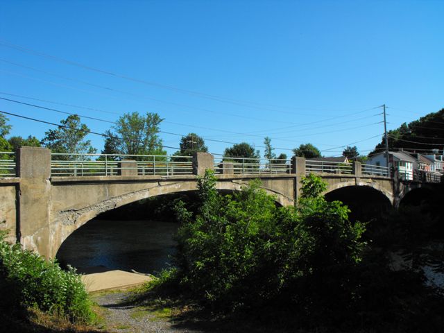
This bridge is a traditionally composed example of a concrete arch bridge. However, the metal pole railings with a combination of metal and concrete posts are relatively uncommon since the majority of concrete arch bridges in Pennsylvania have a concrete balustrade railing of some sort. Aside from the addition of a cantilevered sidewalk to one side of the bridge the structure retains good historic integrity. Although the majority of the original light posts have been lost, the ornately decorated bases of them remain on the railing posts.
Information and Findings From Pennsylvania's Historic Bridge InventoryDiscussion of Bridge The 3-span, 213'-long reinforced concrete deck arch bridge was built in 1915 by a prolific reinforced concrete bridge fabricator. It is finished with pipe railings with concrete posts. A cantilevered sidewalk with a metal mesh railing was added to the downstream side in 1955. The bridge is not an early or distinguished example of its technology, and it has been altered by the addition of the modern sidewalk. Neither the bridge nor its setting are historically or technologically significant. Discussion of Surrounding Area The bridge carries a 2 lane state highway and a cantilevered sidewalk (not original) over a river in the Borough of Leesport. Modern development dominates the east side, and the west side has altered 19th and 20th century vernacular houses. There is a narrow greenway along the west bank of the river. The area does not have the consistency or cohesiveness to be a potential historic district. Bridge Considered Historic By Survey: Yes |
![]()
![]()
![]()
Coordinates (Latitude, Longitude):
Search For Additional Bridge Listings:
Bridgehunter.com: View listed bridges within 0.5 miles (0.8 kilometers) of this bridge.
Bridgehunter.com: View listed bridges within 10 miles (16 kilometers) of this bridge.
Additional Maps:
Google Streetview (If Available)
GeoHack (Additional Links and Coordinates)
Apple Maps (Via DuckDuckGo Search)
Apple Maps (Apple devices only)
Android: Open Location In Your Map or GPS App
Flickr Gallery (Find Nearby Photos)
Wikimedia Commons (Find Nearby Photos)
Directions Via Sygic For Android
Directions Via Sygic For iOS and Android Dolphin Browser
USGS National Map (United States Only)
Historical USGS Topo Maps (United States Only)
Historic Aerials (United States Only)
CalTopo Maps (United States Only)

© Copyright 2003-2024, HistoricBridges.org. All Rights Reserved. Disclaimer: HistoricBridges.org is a volunteer group of private citizens. HistoricBridges.org is NOT a government agency, does not represent or work with any governmental agencies, nor is it in any way associated with any government agency or any non-profit organization. While we strive for accuracy in our factual content, HistoricBridges.org offers no guarantee of accuracy. Information is provided "as is" without warranty of any kind, either expressed or implied. Information could include technical inaccuracies or errors of omission. Opinions and commentary are the opinions of the respective HistoricBridges.org member who made them and do not necessarily represent the views of anyone else, including any outside photographers whose images may appear on the page in which the commentary appears. HistoricBridges.org does not bear any responsibility for any consequences resulting from the use of this or any other HistoricBridges.org information. Owners and users of bridges have the responsibility of correctly following all applicable laws, rules, and regulations, regardless of any HistoricBridges.org information.
![]()