

View Information About HSR Ratings
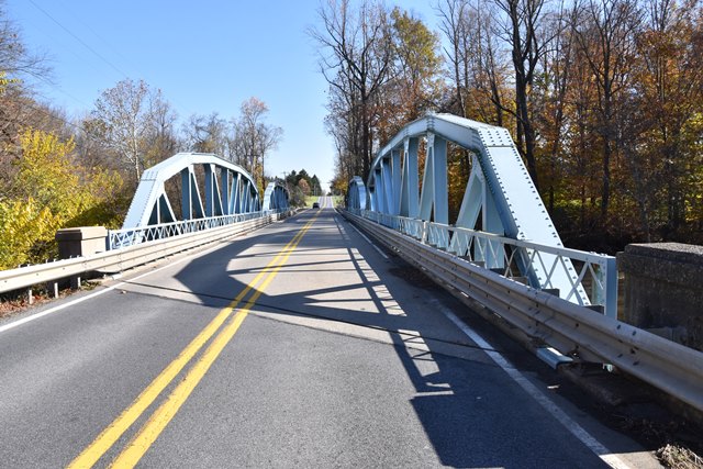
This state standard pony truss is noted for its two-span configuration and its skew. It is also noted for retaining its original railings although Armco guardrail has been added as well.
Information and Findings From Pennsylvania's Historic Bridge InventoryDiscussion of Bridge The skewed, 2-span, 226'-long, rivet-connected, Parker pony truss built in 1932 has built-up chords and rolled section verticals and diagonals. It is supported on concrete abutments and pier. It is finished with lattice railings. The Parker truss design was developed in the 1870s and it is a variation of the Pratt design, only with a polygonal top chord. This example is the standardized design frequently used by the state highway department beginning in the late 1920s. Over 105 pre-1957 Parker truss highway bridges have been identified with more than 80 rivet-connected examples dating after 1925. This example has all standard features and is not technologically noteworthy. It is not distinguished by its setting or context. Discussion of Surrounding Area The bridge carries a 2 lane road over a stream in a forested setting. At the bridge's northwest quadrant is a campground. Lickdale, a crossroads village of scattered altered late 19th century residences and a convenience store at the intersection of SR 72 and SR 1020, is located appoximately 1/4 mile to the west. The setting does not have the cohesiveness or integrity of a historic district. Bridge Considered Historic By Survey: No |
![]()
![]()
![]()
Coordinates (Latitude, Longitude):
Search For Additional Bridge Listings:
Bridgehunter.com: View listed bridges within 0.5 miles (0.8 kilometers) of this bridge.
Bridgehunter.com: View listed bridges within 10 miles (16 kilometers) of this bridge.
Additional Maps:
Google Streetview (If Available)
GeoHack (Additional Links and Coordinates)
Apple Maps (Via DuckDuckGo Search)
Apple Maps (Apple devices only)
Android: Open Location In Your Map or GPS App
Flickr Gallery (Find Nearby Photos)
Wikimedia Commons (Find Nearby Photos)
Directions Via Sygic For Android
Directions Via Sygic For iOS and Android Dolphin Browser
USGS National Map (United States Only)
Historical USGS Topo Maps (United States Only)
Historic Aerials (United States Only)
CalTopo Maps (United States Only)

© Copyright 2003-2025, HistoricBridges.org. All Rights Reserved. Disclaimer: HistoricBridges.org is a volunteer group of private citizens. HistoricBridges.org is NOT a government agency, does not represent or work with any governmental agencies, nor is it in any way associated with any government agency or any non-profit organization. While we strive for accuracy in our factual content, HistoricBridges.org offers no guarantee of accuracy. Information is provided "as is" without warranty of any kind, either expressed or implied. Information could include technical inaccuracies or errors of omission. Opinions and commentary are the opinions of the respective HistoricBridges.org member who made them and do not necessarily represent the views of anyone else, including any outside photographers whose images may appear on the page in which the commentary appears. HistoricBridges.org does not bear any responsibility for any consequences resulting from the use of this or any other HistoricBridges.org information. Owners and users of bridges have the responsibility of correctly following all applicable laws, rules, and regulations, regardless of any HistoricBridges.org information.
![]()