

View Information About HSR Ratings
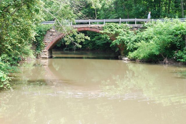
This bridge is a very unusual bridge which has a red brick ring and stone spandrel walls. While other examples of this type of construction exist in Pennsylvania, brick and stone arch bridges are very uncommon with all-stone bridges being far more common. This particular example has a somewhat crude appearance to it, due to the rough appearance of the stones. The color of the stones contrast nicely with the brick however, making the bridge visually pleasing. While the original parapet railings have been lost, the majority of the bridge is original and unaltered. The perhaps overly judgmental Historic Bridge Inventory makes it sound like half the spandrel wall has been replaced, however it appears that perhaps only the top course of stone was replaced with concrete.
The National Bridge Inventory lists a 1930 construction date which appears to be incorrect.
Information and Findings From Pennsylvania's Historic Bridge InventoryDiscussion of Bridge The bridge carries one lane of traffic over a stream in a sparsely developed, forested setting. Discussion of Surrounding Area The 1-span, 29'-long brick arch bridge has stone spandrel walls and abutments. The bridge, which dates in style from ca. 1900, has lost its historic integrity because of removal of the parapets and upper portions of the spandrel walls. W-beam guiderails have been added with posts embedded in concrete curbs (ca. 1980). Better examples of early 20th century brick arch bridges have been identified in the county and region (50722104664004). The builder of this bridge is undocumented in state records. The altered bridge is not distinguished by its setting or context. Bridge Considered Historic By Survey: No |
![]()
![]()
![]()
Coordinates (Latitude, Longitude):
Search For Additional Bridge Listings:
Bridgehunter.com: View listed bridges within 0.5 miles (0.8 kilometers) of this bridge.
Bridgehunter.com: View listed bridges within 10 miles (16 kilometers) of this bridge.
Additional Maps:
Google Streetview (If Available)
GeoHack (Additional Links and Coordinates)
Apple Maps (Via DuckDuckGo Search)
Apple Maps (Apple devices only)
Android: Open Location In Your Map or GPS App
Flickr Gallery (Find Nearby Photos)
Wikimedia Commons (Find Nearby Photos)
Directions Via Sygic For Android
Directions Via Sygic For iOS and Android Dolphin Browser
USGS National Map (United States Only)
Historical USGS Topo Maps (United States Only)
Historic Aerials (United States Only)
CalTopo Maps (United States Only)

© Copyright 2003-2024, HistoricBridges.org. All Rights Reserved. Disclaimer: HistoricBridges.org is a volunteer group of private citizens. HistoricBridges.org is NOT a government agency, does not represent or work with any governmental agencies, nor is it in any way associated with any government agency or any non-profit organization. While we strive for accuracy in our factual content, HistoricBridges.org offers no guarantee of accuracy. Information is provided "as is" without warranty of any kind, either expressed or implied. Information could include technical inaccuracies or errors of omission. Opinions and commentary are the opinions of the respective HistoricBridges.org member who made them and do not necessarily represent the views of anyone else, including any outside photographers whose images may appear on the page in which the commentary appears. HistoricBridges.org does not bear any responsibility for any consequences resulting from the use of this or any other HistoricBridges.org information. Owners and users of bridges have the responsibility of correctly following all applicable laws, rules, and regulations, regardless of any HistoricBridges.org information.
![]()