

View Information About HSR Ratings

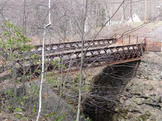
This bridge is an example of an exceedingly rare structure type, that being a latticed through girder. A latticed through girder is essentially like a through plate girder, except that instead of a solid wall of plate, a system of diagonal members provides a truss-like web. This has the effect of reducing the required materials to fabricate the bridge, making it an efficient design. Nationwide, there are hardly any examples of this bridge type remaining. The preservation of each surviving example should be considered essential.
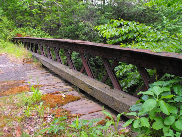
This example has unaltered girders that retain excellent historic integrity, however the floorbeams are replacements dating to 1950. This fact actually makes the bridge more easy to preserve, since all that needs to be retained during a preservation project is the girders. The girders do exhibit some section loss and deterioration on the lower portion of the girders, but the girders remain in a condition where restoration for non-motorized use would be quite feasible.
Despite its rarity and significance, this historic bridge is slated to be demolished, with no replacement planned. To fulfill Section 106, PennDOT has had a state level recordation of the bridge prepared (which does offer a nice history of the bridge) and also has attempted to market this historic bridge for relocation and preservation elsewhere. Thus far, it appears the marketing attempt has been unsuccessful.
If the attempt to market the bridge is unsuccessful, the bridge will be demolished. This is absolutely ridiculous, and this plan needs to be halted immediately. Instead, if the marketing effort is unsuccessful, what needs to happen is the girders of the bridge should be carefully lifted off the abutments and either placed into storage someplace such as a highway maintenance yard/garage, or alternatively the girders should be placed in a public area as a non-functional interpretive exhibit. Both of these alternatives should not cost much of anything in excess of the cost to demolish the bridge. As mentioned earlier, the floorbeams of this bridge are not original. The only part of the bridge that needs to be relocated or stored is the girders. Take a look at this bridge. It is under 50 feet long! All that has to be done is to use a crane to lift these girders onto a truck and haul them either to a park or storage area, and set them somewhere. They could even be put on display in the front yard of a PennDOT district office. The process to preserve this bridge is hardly any different than the process which would be used to send the bridge to a scrapyard! Why on earth would this bridge not be preserved? It is a free preservation success story for PennDOT and any other involved agency! It is extremely disturbing that Pennsylvania would not pursue such an easy preservation project, particularly for a bridge with the rarity and significance of the Mary Street Bridge.
Information and Findings From Pennsylvania's Historic Bridge InventoryDiscussion of Bridge The single span, 47'-long, lattice thru girder bridge built in 1894 is supported on rubble stone abutments. The girders are composed of built-up sections for the upper and lower flanges and webs with rolled T-section and plate. The rolled floorbeams (ca. 1950) are set directly on the girder flanges. The bridge has rolled stringers and wood plank deck. Built-up girders, to make an I-beam section of sufficient depth to span greater distances than possible with the available rolled beams, were developed by the railroads in the late 1840s, and the technology proved to be the only serious competitor to the metal truss for railroad use in the 19th century. Taking advantage of the tensile strength of wrought iron and later steel, the built-up girder, which could be fabricated off site and easily transported and then hoisted into position, proved to be a boon to the railroads. Literally thousands of built-up deck and thru girder bridges were built for the railroads during the 19th and early 20th centuries, but surviving pre-1900 examples are not common. Some early examples have lattice webs rather than solid webs. The bridge is historically and technologically significant as among the earliest surviving examples of its type/design in Pennsylvania. Discussion of Surrounding Area The 1-lane bridge over a single active railroad track in a cut is closed to traffic. Woods are to all quadrants, although the area has scattered 19th to late 20th century buildings. The setting does not have the cohesiveness or integrity of a historic district. The rail line is the former Central RR of NJ main line from Easton to Wilkes-Barre, completed in 1866. The line was primarily an anthracite coal hauler. Bridge Considered Historic By Survey: Yes |
![]()
![]()
![]()
![]()
![]()
Coordinates (Latitude, Longitude):
Search For Additional Bridge Listings:
Bridgehunter.com: View listed bridges within 0.5 miles (0.8 kilometers) of this bridge.
Bridgehunter.com: View listed bridges within 10 miles (16 kilometers) of this bridge.
Additional Maps:
Google Streetview (If Available)
GeoHack (Additional Links and Coordinates)
Apple Maps (Via DuckDuckGo Search)
Apple Maps (Apple devices only)
Android: Open Location In Your Map or GPS App
Flickr Gallery (Find Nearby Photos)
Wikimedia Commons (Find Nearby Photos)
Directions Via Sygic For Android
Directions Via Sygic For iOS and Android Dolphin Browser
USGS National Map (United States Only)
Historical USGS Topo Maps (United States Only)
Historic Aerials (United States Only)
CalTopo Maps (United States Only)

© Copyright 2003-2024, HistoricBridges.org. All Rights Reserved. Disclaimer: HistoricBridges.org is a volunteer group of private citizens. HistoricBridges.org is NOT a government agency, does not represent or work with any governmental agencies, nor is it in any way associated with any government agency or any non-profit organization. While we strive for accuracy in our factual content, HistoricBridges.org offers no guarantee of accuracy. Information is provided "as is" without warranty of any kind, either expressed or implied. Information could include technical inaccuracies or errors of omission. Opinions and commentary are the opinions of the respective HistoricBridges.org member who made them and do not necessarily represent the views of anyone else, including any outside photographers whose images may appear on the page in which the commentary appears. HistoricBridges.org does not bear any responsibility for any consequences resulting from the use of this or any other HistoricBridges.org information. Owners and users of bridges have the responsibility of correctly following all applicable laws, rules, and regulations, regardless of any HistoricBridges.org information.
![]()