

View Information About HSR Ratings
This traditionally composed plate girder retains an original concrete curb as well as original steel pedestrian railings for the sidewalks. It connects to the larger and more significant steel arch bridge nearby.
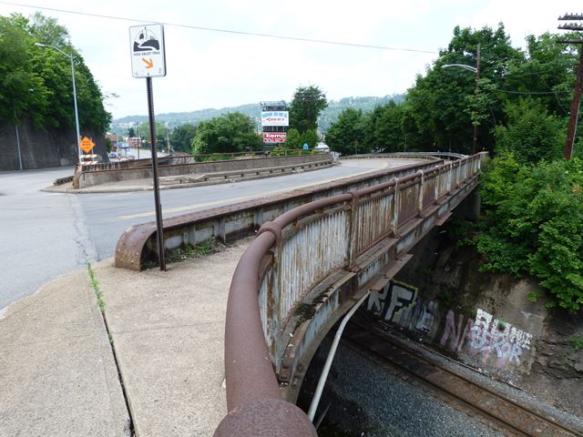
Information and Findings From Pennsylvania's Historic Bridge InventoryDiscussion of Bridge The ca. 1949, skewed, single span, built up thru girder bridge is supported on concrete abutments. The bridge has built up floorbeams and a concrete deck. The bridge is an example of a common type with no innovative or distinguishing detail. Girder bridges were first developed by the railroad industry in the 1850s, and they were used on vehicular roadways in Allegheny County beginning in the late 19th century. Neither the bridge nor its setting and context are historically or technologically noteworthy. Discussion of Surrounding Area The bridge carries a 2 lane road and 2 sidewalks over a single active railroad track just west of the 5th Avenue Bridge, a tied arch bridge spanning the Youghiogheny River. The rail line was originally built by the Three Rivers Railroad, a subsidiary of the Pittsburgh & Lake Erie RR that served the steel mills of the Monongahela Valley. US Steel's former McKeesport Tubes Works lies just east, across the river. The SHPO has determined the P&LE's main line as an NR-eligible resource, although no period of significance has been determined. However, the thru girder bridge was built in 1949, when the American railroad industry was in decline, and the grade crossing bridge was driven by a highway improvement project rather than as a means to increase railroad efficiency. For these reasons, the bridge does not appear to be potentially significant in association with the P&LE. Bridge Considered Historic By Survey: No |
![]()
![]()
![]()
Coordinates (Latitude, Longitude):
Search For Additional Bridge Listings:
Bridgehunter.com: View listed bridges within 0.5 miles (0.8 kilometers) of this bridge.
Bridgehunter.com: View listed bridges within 10 miles (16 kilometers) of this bridge.
Additional Maps:
Google Streetview (If Available)
GeoHack (Additional Links and Coordinates)
Apple Maps (Via DuckDuckGo Search)
Apple Maps (Apple devices only)
Android: Open Location In Your Map or GPS App
Flickr Gallery (Find Nearby Photos)
Wikimedia Commons (Find Nearby Photos)
Directions Via Sygic For Android
Directions Via Sygic For iOS and Android Dolphin Browser
USGS National Map (United States Only)
Historical USGS Topo Maps (United States Only)
Historic Aerials (United States Only)
CalTopo Maps (United States Only)

© Copyright 2003-2024, HistoricBridges.org. All Rights Reserved. Disclaimer: HistoricBridges.org is a volunteer group of private citizens. HistoricBridges.org is NOT a government agency, does not represent or work with any governmental agencies, nor is it in any way associated with any government agency or any non-profit organization. While we strive for accuracy in our factual content, HistoricBridges.org offers no guarantee of accuracy. Information is provided "as is" without warranty of any kind, either expressed or implied. Information could include technical inaccuracies or errors of omission. Opinions and commentary are the opinions of the respective HistoricBridges.org member who made them and do not necessarily represent the views of anyone else, including any outside photographers whose images may appear on the page in which the commentary appears. HistoricBridges.org does not bear any responsibility for any consequences resulting from the use of this or any other HistoricBridges.org information. Owners and users of bridges have the responsibility of correctly following all applicable laws, rules, and regulations, regardless of any HistoricBridges.org information.
![]()