

View Information About HSR Ratings
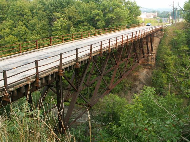
One of the most unusual bridges in this region that is rich with historic bridges, this structure is an extremely rare example of a pin-connected double-intersection Warren. The double Warren is uncommon enough, but many examples of this type feature riveted connections and date to the early 20th Century. Thus, this c. 1890 structure is an extremely early and rare pin-connected example of the type. It also retains excellent historic integrity with little alteration detected.
Pennsylvania has a habit of picking its rarest historic bridges and targeting them for demolition, and this bridge is no exception. After following the prescribed federal guidelines for demolishing a historic bridge, this bridge was offered to a third party for relocation and preservation. As one might expect, few private individuals or nonprofit groups have the resources to preserve a structure like this. For this reason, this process of bridge marketing is largely ineffective. Our government has been charged with the people and Congress to care for this country's heritage as outlined through various historic preservation legislation. However, there are serious flaws in the legislation. A bridge such as the Monastery Road Bridge should not face demolition because local residents and groups don't have $1,000,000 laying around in the loose change jar. A bridge like the Monastery Road Bridge should be preserved by its government owner, perhaps with grants and assistance from higher levels.
While this bridge may not be acceptable as a vehicular bridge, it certainly could and should be restored, either here or in a new location, for non-motorized traffic.
The National Bridge Inventory gives a construction date of 1920 for this bridge, which is obviously incorrect, but it might reflect a rehabilitation date, or further might confirm the thoughts of the Historic Bridge Inventory that this bridge was originally a rail bridge, perhaps located somewhere else. 1920 might be when it became a highway bridge on Monastery Road.
Information and Findings From Pennsylvania's Historic Bridge InventoryDiscussion of Bridge The main span of the ca. 1890, 3 span, 228' long bridge is a 157' long, pin-connected double intersection Warren deck truss with subdivided panels. The approach spans are built up deck girders. The bridge is supported on ashlar abutments. The truss is 20'-9" deep. The design of the flooring system, where the asphalt deck is supported on railroad ties suggests that the bridge was originally a rail carrying facility. The bridge is significant as a rare example of type and design. It also appears to be remarkably complete, and its idiosyncratic design illustrates the evolution of metal truss bridges. Discussion of Surrounding Area The bridge carries a 2 lane road over 2 active tracks of the former Pennsylvania Railroad main line now operated by Conrail and an access road in a sparsely developed, rural area. A ca. 1970 factory is located beyond the southeast quadrant. PHMC has determined eligible the Main Line from Philadelphia to the Ohio State Line (DOE 9/14/93), but no period of significance or definition of contributing and noncontributing resources was part of that determination. Bridge Considered Historic By Survey: Yes |
![]()
![]()
This historic bridge has been demolished. This map is shown for reference purposes only.
Coordinates (Latitude, Longitude):
Search For Additional Bridge Listings:
Bridgehunter.com: View listed bridges within 0.5 miles (0.8 kilometers) of this bridge.
Bridgehunter.com: View listed bridges within 10 miles (16 kilometers) of this bridge.
Additional Maps:
Google Streetview (If Available)
GeoHack (Additional Links and Coordinates)
Apple Maps (Via DuckDuckGo Search)
Apple Maps (Apple devices only)
Android: Open Location In Your Map or GPS App
Flickr Gallery (Find Nearby Photos)
Wikimedia Commons (Find Nearby Photos)
Directions Via Sygic For Android
Directions Via Sygic For iOS and Android Dolphin Browser
USGS National Map (United States Only)
Historical USGS Topo Maps (United States Only)
Historic Aerials (United States Only)
CalTopo Maps (United States Only)

© Copyright 2003-2025, HistoricBridges.org. All Rights Reserved. Disclaimer: HistoricBridges.org is a volunteer group of private citizens. HistoricBridges.org is NOT a government agency, does not represent or work with any governmental agencies, nor is it in any way associated with any government agency or any non-profit organization. While we strive for accuracy in our factual content, HistoricBridges.org offers no guarantee of accuracy. Information is provided "as is" without warranty of any kind, either expressed or implied. Information could include technical inaccuracies or errors of omission. Opinions and commentary are the opinions of the respective HistoricBridges.org member who made them and do not necessarily represent the views of anyone else, including any outside photographers whose images may appear on the page in which the commentary appears. HistoricBridges.org does not bear any responsibility for any consequences resulting from the use of this or any other HistoricBridges.org information. Owners and users of bridges have the responsibility of correctly following all applicable laws, rules, and regulations, regardless of any HistoricBridges.org information.
![]()