


View Information About HSR Ratings
HistoricBridges.org was the first bridge website on the Internet to discover and photo-document this extremely important historic bowstring truss bridge that is constructed in the style of 1870s bowstring bridges. The bridge was discovered using aerial imagery then confirmed and photographed with a follow-up field visit to the bridge. Later, this bridge was brought to the attention of PennDOT as efforts to preserve the bridge and find a new home ramped up. Some old records about the bridge were located and they add an element of mystery to the bridge. These inventory documents are available on this page below. Based on the design of the top chord the bridge would appear to be the work of the King Bridge Company of Cleveland, Ohio. However, the bridge displays details unlike other King bowstrings. One such detail is the design of the vertical members which have a unique shallowly tapered design with a curved detail at the top. The decorative knee bracing is unusual as well. However the aforementioned inventory documents provide a drastically different history. They state that this bridge was actually built for the Schuykill Electric Railway in the 1890s! This is truly remarkable as the bridge's lightweight design was not even being used for highway bridges in the 1890s let alone for railroad usage (which did not usually use bowstring truss bridges likely due to their lack of lateral stability compared to other bridge types). One cannot help but wonder if some detail is missing in the history being presented. For example, could this bridge have been a salvaged, relocated, and reused 1870s bowstring bridge that was converted for use by this trolley line? The following is an excerpt of the history in the inventory documents:
The Schuylkill Electric Railway Company was chartered on October 5, 1889. The new electric railway leased the tracks running down Centre Street which were no longer used by the People's Railway. One of the conditions of the lease provided for future extensions to nearby towns around Pottsville, including Palo Alto, Port Carbon, and Tumbling Run (Gordon 1990). The bowstring arch truss bridge which crosses the Schuylkill River south of Pottsville at Mt. Carbon lies within the Schuylkill Haven Branch of the Schuylkill Electric Railway. Surveys for the Schuylkill Haven extension were undertaken by company surveyor, J.W. Geary, Jr., in July of 1895. The course of the Schuylkill Haven extension was set to exit Pottsville from South Centre and Mauch Chunk Streets and would then run "through the center of the Centre Pike, along the side of the hill below the Mansion House, thence through the lower archway, south through the McWilliams property and along a stretch of vacant land of the P & R Co. It would then continue west of the 'black Bridge,' down the river side to Cape Horn, where the towpath would be taken as much as possible until the Centre Pike was reached and then on to Schuylkill Haven where it would come down Dock St. through Spring Garden to Front Street" (Gordon 1990). The "lower archway" refers to a concrete structure which allowed the trolley to pass under the tracks of the Philadelphia and Reading railroad. Trolley cars passed through the lower archway and then onto the bridge. The upper archway was (and still is) used by automobiles. The work for this section of the trolley line was contracted to T.H. Connell. After several delays, the first half mile of track for the Schuylkill Haven branch was laid on November 19, 1896. By January of 1897 two miles of track had been laid and the roadbed for the rest of the line was partially built (Gordon 1990). William A. Cochran served as engineer in the construction of three bridges which were to be erected between Pottsville and Schuylkill Haven (Gordon 1990). These bridges were located at Mt. Carbon, Cape Horn and Seven Stars. The Mount Carbon bridge is the only one of these bridges which survives.
Fabrication of the steelwork for these bridges was completed by the Pottsville Bridge Works in Fishbach (a neighborhood in northeast Pottsville). The bridge works was operated by the Pottsville Iron and Steel Company on Peacock Street. According to an 1886 mill catalogue, the mill fabricated roof trusses, columns and girders. Annual capacity of the Pottsville Bridge Works was listed as 7500 long tons for the years 1894, 1896, and 1898. The Pottsville Iron and Steel Company was in operation from 1891-1900, when the shop was leased by the Berlin Construction Company (Darnell 1984).
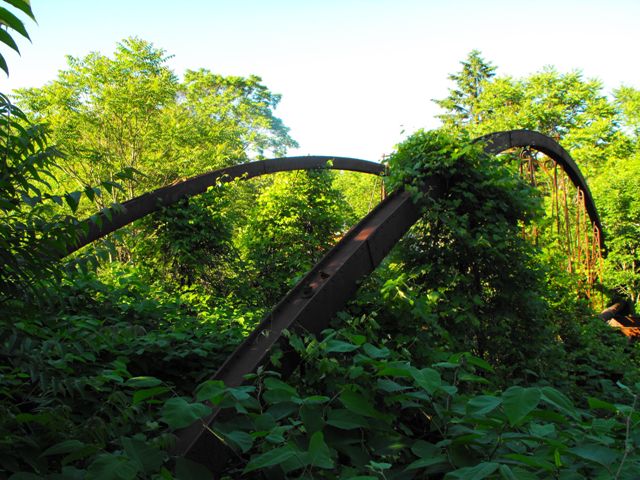
The bridge sits bypassed and abandoned right next to a historic 1925 concrete arch bridge. The bridge carries a water pipeline along the truss, which may have something to do with why it has been left in place all these years. Having been left in place for decades without any traffic or corrosive deicing salts on it, the bridge appears to retain an extremely high degree of historic and structural integrity. The bridge has no deck although floorbeams and deck stringers remain in place. The bridge sits in an overgrown area with numerous large shrubs surrounding it.
This is a bridge that deserves to be accessible to the public. Fortunately a plan is in the works to restored and relocate this bridge to St. Clair, Pennsylvania in a commercial area where many people (even people who may not be familiar or previously interested in historic bridges) will get to see this spectacular bridge in all its glory. Bowstring truss bridges dating to the 1870s such as this one are among the oldest, rarest, and most historically significant of metal bridges in the United States, and the preservation of each surviving example is absolutely essential.
This bridge is tagged with the following special condition(s): Unorganized Photos
![]()
![]()
![]()
![]()
![]()
Coordinates (Latitude, Longitude):
Search For Additional Bridge Listings:
Bridgehunter.com: View listed bridges within 0.5 miles (0.8 kilometers) of this bridge.
Bridgehunter.com: View listed bridges within 10 miles (16 kilometers) of this bridge.
Additional Maps:
Google Streetview (If Available)
GeoHack (Additional Links and Coordinates)
Apple Maps (Via DuckDuckGo Search)
Apple Maps (Apple devices only)
Android: Open Location In Your Map or GPS App
Flickr Gallery (Find Nearby Photos)
Wikimedia Commons (Find Nearby Photos)
Directions Via Sygic For Android
Directions Via Sygic For iOS and Android Dolphin Browser
USGS National Map (United States Only)
Historical USGS Topo Maps (United States Only)
Historic Aerials (United States Only)
CalTopo Maps (United States Only)

© Copyright 2003-2025, HistoricBridges.org. All Rights Reserved. Disclaimer: HistoricBridges.org is a volunteer group of private citizens. HistoricBridges.org is NOT a government agency, does not represent or work with any governmental agencies, nor is it in any way associated with any government agency or any non-profit organization. While we strive for accuracy in our factual content, HistoricBridges.org offers no guarantee of accuracy. Information is provided "as is" without warranty of any kind, either expressed or implied. Information could include technical inaccuracies or errors of omission. Opinions and commentary are the opinions of the respective HistoricBridges.org member who made them and do not necessarily represent the views of anyone else, including any outside photographers whose images may appear on the page in which the commentary appears. HistoricBridges.org does not bear any responsibility for any consequences resulting from the use of this or any other HistoricBridges.org information. Owners and users of bridges have the responsibility of correctly following all applicable laws, rules, and regulations, regardless of any HistoricBridges.org information.
![]()