

View Information About HSR Ratings
Additional Notes: Ben Construction Company was contractor for the approaches and Dravo Corporation was the substructure contractor.
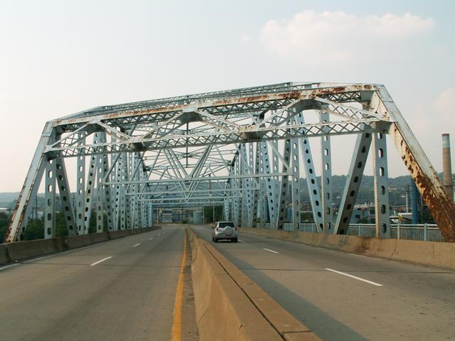
This bridge is a large example of a bridge that represents very well what truss bridges of the mid-20th Century looked like. The presence of members and chords that feature built-up members including plate steel with holes highlights the key visual difference with bridges that were built in this area, as this stronger, albeit less attractive form of built-up beam became popular. Regardless, the Fleming Park Bridge remains an attractive structure largely due to its size, as it is of decent length, but is also quite wide, making it an impressive structure to view.
Information and Findings From Pennsylvania's Historic Bridge InventoryDiscussion of Bridge The 5-span, 807'-long bridge built in 1955 consists of a 361'-long, rivet-connected steel Warren thru truss with a polygonal top chord and four deck girder approach spans. The southernmost deck girder span is continuous over the pier and cantilevers out with a seat for the bearing of the adjacent span. The bridge was damaged in a truck fire in 1981, and repairs included the bolting of plates to a number of weakened truss members. A new deck, sidewalk, safety-shape parapets, and median barrier were installed. The bridge is a large but late example of the rivet-connected Warren thru truss type and design that were developed in the last half of the 19th century, and common on the state's highways by 1905. It has no unusual or distinctive details. It is not historically or technologically distinguished by its setting or context. Discussion of Surrounding Area The bridge carries 4 lanes of median divided traffic over Pittsburgh & Lake Erie RR tracks and the back channel of the Ohio River between Stowe Township and Neville Island. The setting is a scattered mix of late-19th to late-20th-century industrial and residential development that does not have the cohesiveness or integrity of a potential historic district. Bridge Considered Historic By Survey: No |
![]()
![]()
Coordinates (Latitude, Longitude):
Search For Additional Bridge Listings:
Bridgehunter.com: View listed bridges within 0.5 miles (0.8 kilometers) of this bridge.
Bridgehunter.com: View listed bridges within 10 miles (16 kilometers) of this bridge.
Additional Maps:
Google Streetview (If Available)
GeoHack (Additional Links and Coordinates)
Apple Maps (Via DuckDuckGo Search)
Apple Maps (Apple devices only)
Android: Open Location In Your Map or GPS App
Flickr Gallery (Find Nearby Photos)
Wikimedia Commons (Find Nearby Photos)
Directions Via Sygic For Android
Directions Via Sygic For iOS and Android Dolphin Browser
USGS National Map (United States Only)
Historical USGS Topo Maps (United States Only)
Historic Aerials (United States Only)
CalTopo Maps (United States Only)

© Copyright 2003-2024, HistoricBridges.org. All Rights Reserved. Disclaimer: HistoricBridges.org is a volunteer group of private citizens. HistoricBridges.org is NOT a government agency, does not represent or work with any governmental agencies, nor is it in any way associated with any government agency or any non-profit organization. While we strive for accuracy in our factual content, HistoricBridges.org offers no guarantee of accuracy. Information is provided "as is" without warranty of any kind, either expressed or implied. Information could include technical inaccuracies or errors of omission. Opinions and commentary are the opinions of the respective HistoricBridges.org member who made them and do not necessarily represent the views of anyone else, including any outside photographers whose images may appear on the page in which the commentary appears. HistoricBridges.org does not bear any responsibility for any consequences resulting from the use of this or any other HistoricBridges.org information. Owners and users of bridges have the responsibility of correctly following all applicable laws, rules, and regulations, regardless of any HistoricBridges.org information.
![]()