

View Information About HSR Ratings
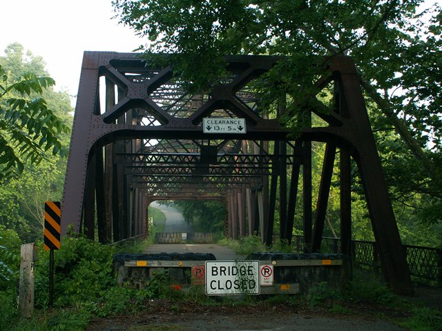
This bridge is a classic example of Pennsylvania's standard plan through Parker truss plan. It is closed to traffic and National Bridge Inventories list as being in a deteriorated condition. Its hard to imagine that a bulky 1935 bridge like this, following a design similar to other bridges in Pennsylvania that remain open to heavy traffic, has widespread deterioration. The reality is that even thought the bridge is currently closed, this bridge could certainly could be restored without much difficulty. The bridge is in a scenic area, and is located near a campground. Many people would enjoy seeing this bridge brought to life again, perhaps only for pedestrian use.
Information and Findings From Pennsylvania's Historic Bridge InventoryDiscussion of Bridge The one-span, 190'-long, riveted, steel Parker thru truss bridge dates stylistically to ca. 1935, and it is an example of a commonly used state standard design of the period. It is located on a bypassed section of state highway. The trusses are fabricated from built-up steel members and rolled sections and is supported on concrete abutments. The original riveted lattice railings are inside one truss line and at the cantilevered sidewalk. The bridge has no innovative or distinctive details, and neither it nor its setting are historically or technologically significant. Discussion of Surrounding Area The bridge carries a two-lane road over Slippery Rock Creek in a sparsely developed, wooded rural area with scattered 20th century residences and the Rose Point campground beyond the northwest quadrant. There are modern houses beyond the southeast quadrant. The setting does not have historic district potential. Bridge Considered Historic By Survey: No |
![]()
![]()
![]()
Coordinates (Latitude, Longitude):
Search For Additional Bridge Listings:
Bridgehunter.com: View listed bridges within 0.5 miles (0.8 kilometers) of this bridge.
Bridgehunter.com: View listed bridges within 10 miles (16 kilometers) of this bridge.
Additional Maps:
Google Streetview (If Available)
GeoHack (Additional Links and Coordinates)
Apple Maps (Via DuckDuckGo Search)
Apple Maps (Apple devices only)
Android: Open Location In Your Map or GPS App
Flickr Gallery (Find Nearby Photos)
Wikimedia Commons (Find Nearby Photos)
Directions Via Sygic For Android
Directions Via Sygic For iOS and Android Dolphin Browser
USGS National Map (United States Only)
Historical USGS Topo Maps (United States Only)
Historic Aerials (United States Only)
CalTopo Maps (United States Only)

© Copyright 2003-2025, HistoricBridges.org. All Rights Reserved. Disclaimer: HistoricBridges.org is a volunteer group of private citizens. HistoricBridges.org is NOT a government agency, does not represent or work with any governmental agencies, nor is it in any way associated with any government agency or any non-profit organization. While we strive for accuracy in our factual content, HistoricBridges.org offers no guarantee of accuracy. Information is provided "as is" without warranty of any kind, either expressed or implied. Information could include technical inaccuracies or errors of omission. Opinions and commentary are the opinions of the respective HistoricBridges.org member who made them and do not necessarily represent the views of anyone else, including any outside photographers whose images may appear on the page in which the commentary appears. HistoricBridges.org does not bear any responsibility for any consequences resulting from the use of this or any other HistoricBridges.org information. Owners and users of bridges have the responsibility of correctly following all applicable laws, rules, and regulations, regardless of any HistoricBridges.org information.
![]()