

View Information About HSR Ratings
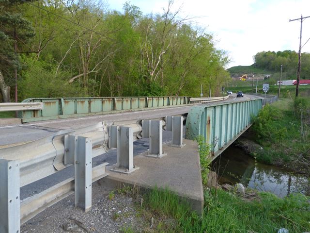
This bridge is a traditionally composed example of a highway through plate girder in Pennsylvania. The through plate girder was common on railroads, and common in a couple states like Pennsylvania and New York, but in many states they are uncommon to find on highways. This example shows signs of substantial section loss in the girder web where the builder plaques are/were mounted, evidence of how placing metal on top of metal traps moisture leading to deterioration. What does this fact mean for preservation work? If bridge plaques are mounted on bridge superstructure metal, preservation work may involve remounting the plaque so that it does not rest against the metal. Placing washers on the bolts may accomplish this for example. Alternatively, sealing the area behind the plaque away from moisture may be a possibility.
Information and Findings From Pennsylvania's Historic Bridge InventoryDiscussion of Bridge The 65'-long, built-up, steel through girder bridge, built in 1916, is supported on reinforced concrete abutments with wingwalls. Girder bridges were first developed by the railroad industry in the 1850s, and they were used on roadways beginning in the late 19th century. The bridge is a common type used by Washington County in the 1900s and into the 1910s. The bridge is of common design, and neither it nor its setting are historically or technologically significant. Discussion of Surrounding Area The bridge carries a two-lane road over a stream in an area dominated by undistinguished 20th century commercial development in the village of Finleyville. The area does not appear to have historic district potential. Bridge Considered Historic By Survey: No |
![]()
![]()
![]()
Coordinates (Latitude, Longitude):
Search For Additional Bridge Listings:
Bridgehunter.com: View listed bridges within 0.5 miles (0.8 kilometers) of this bridge.
Bridgehunter.com: View listed bridges within 10 miles (16 kilometers) of this bridge.
Additional Maps:
Google Streetview (If Available)
GeoHack (Additional Links and Coordinates)
Apple Maps (Via DuckDuckGo Search)
Apple Maps (Apple devices only)
Android: Open Location In Your Map or GPS App
Flickr Gallery (Find Nearby Photos)
Wikimedia Commons (Find Nearby Photos)
Directions Via Sygic For Android
Directions Via Sygic For iOS and Android Dolphin Browser
USGS National Map (United States Only)
Historical USGS Topo Maps (United States Only)
Historic Aerials (United States Only)
CalTopo Maps (United States Only)

© Copyright 2003-2024, HistoricBridges.org. All Rights Reserved. Disclaimer: HistoricBridges.org is a volunteer group of private citizens. HistoricBridges.org is NOT a government agency, does not represent or work with any governmental agencies, nor is it in any way associated with any government agency or any non-profit organization. While we strive for accuracy in our factual content, HistoricBridges.org offers no guarantee of accuracy. Information is provided "as is" without warranty of any kind, either expressed or implied. Information could include technical inaccuracies or errors of omission. Opinions and commentary are the opinions of the respective HistoricBridges.org member who made them and do not necessarily represent the views of anyone else, including any outside photographers whose images may appear on the page in which the commentary appears. HistoricBridges.org does not bear any responsibility for any consequences resulting from the use of this or any other HistoricBridges.org information. Owners and users of bridges have the responsibility of correctly following all applicable laws, rules, and regulations, regardless of any HistoricBridges.org information.
![]()