

View Information About HSR Ratings
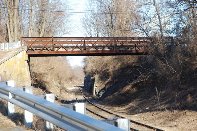
This is an unusual pony truss whose odd design suggests it was designed by the railroad. It is a double-intersection Warren sort of truss, but floor beams only occur at the locations where outriggers are present, which is every other "X" in the truss web, which is an unusual layout. The end posts are vertical. The composition of the bottom and top chords being of angles and plate gives the bridge truss a flat, two dimensional appearance... this style is usually associated with railroad-designed truss bridges. This is therefore a highly unusual and therefore rare and significant historic bridge. The construction date is unknown. The National Bridge Inventory listed a 1920 date which appears to be too late for a bridge of this design.
Information and Findings From Pennsylvania's Historic Bridge InventoryDiscussion of Bridge The 68' long and 26.5' wide riveted double intersection Warren pony truss bridge with squared ends is not a standardized design, and it appears to be a railroad design dating to about 1900. The upper and lower chords are back to back angles with continuous section of plate to which the angle verticals and diagonals are riveted. There are no gusset plates. The built up outriggers are integral with the verticals into which the built up floorbeams are framed. Three thin bands of plate riveted to the diagonals are a railing of sorts. The bridge is technologically significant as a non-standard design of the popular Warren pony truss design and appears to be a railroad design. Discussion of Surrounding Area The bridge carries a 2 lane road over a single track of the former Reading RR Belt Line south of Reading. The line is now part of Conrail. The bridge is west and south of I 676 in a rural setting. There is a junk yard at the north end. Bridge Considered Historic By Survey: Yes |
![]()
![]()
![]()
Coordinates (Latitude, Longitude):
Search For Additional Bridge Listings:
Bridgehunter.com: View listed bridges within 0.5 miles (0.8 kilometers) of this bridge.
Bridgehunter.com: View listed bridges within 10 miles (16 kilometers) of this bridge.
Additional Maps:
Google Streetview (If Available)
GeoHack (Additional Links and Coordinates)
Apple Maps (Via DuckDuckGo Search)
Apple Maps (Apple devices only)
Android: Open Location In Your Map or GPS App
Flickr Gallery (Find Nearby Photos)
Wikimedia Commons (Find Nearby Photos)
Directions Via Sygic For Android
Directions Via Sygic For iOS and Android Dolphin Browser
USGS National Map (United States Only)
Historical USGS Topo Maps (United States Only)
Historic Aerials (United States Only)
CalTopo Maps (United States Only)

© Copyright 2003-2024, HistoricBridges.org. All Rights Reserved. Disclaimer: HistoricBridges.org is a volunteer group of private citizens. HistoricBridges.org is NOT a government agency, does not represent or work with any governmental agencies, nor is it in any way associated with any government agency or any non-profit organization. While we strive for accuracy in our factual content, HistoricBridges.org offers no guarantee of accuracy. Information is provided "as is" without warranty of any kind, either expressed or implied. Information could include technical inaccuracies or errors of omission. Opinions and commentary are the opinions of the respective HistoricBridges.org member who made them and do not necessarily represent the views of anyone else, including any outside photographers whose images may appear on the page in which the commentary appears. HistoricBridges.org does not bear any responsibility for any consequences resulting from the use of this or any other HistoricBridges.org information. Owners and users of bridges have the responsibility of correctly following all applicable laws, rules, and regulations, regardless of any HistoricBridges.org information.
![]()