

View Information About HSR Ratings

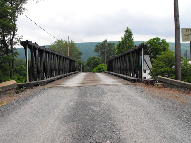
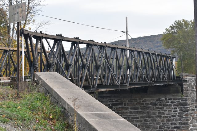
The Reading-Halls Station Bridge is one of the most important historic bridges in the United States. The bridge is so exceedingly old that it was built only approximately a year after the first all-metal truss in the country, the Manayunk Iron Bridge, was built in 1845. Today the Reading-Halls Station Bridge is distinguished as the oldest active metal truss bridge in the United States. The only other older remaining truss in the country is indeed the first metal truss, the Manayunk Iron Bridge. One of the truss webs of the Manaynk Iron Bridge remains on exhibit at Smithsonian's National Museum of American History in Washington D.C. For comparison the Market Street Bridge, the oldest cast iron arch in the United States is only seven years older, having been built in 1839.
The Reading-Halls Station Bridge was designed by Richard B. Osborne, a civil engineer, for the Philadelphia and Reading Railroad. Osborne was also the designer for the aforementioned Manayunk Iron Bridge.
Although the Reading-Halls Station Bridge has been shortened three panels from its original dimensions and the end posts have been replaced, the remaining truss retains excellent historic integrity, particularly considering the bridge's age. The bridge continues to carry vehicular traffic over a Norfolk Southern railroad line for a private farm complex on a dead-end private road. The bridge itself is apparently owned by Norfolk Southern. The bridge was relocated from its original location to its current location sometime between 1884 and 1900.
The bridge displays the ornate, yet structurally functional artistry that only a cast iron bridge can display. This artistry manifests itself in the diagonal members of the bridge which are cast with Egyptian revival motifs.
Given that the bridge is owned by Norfolk Southern Railroad and serves a private drive, this bridge cannot be described to have a preservation commitment. As a private bridge, any involved owners of the bridge and road can choose to do whatever they want with the bridge without any input from the general public, including alteration or complete demolition. One can only hope that this bridge's owners realize that they possess one of the most important bridges in the entire country and that they treat it with the reverence and care that it deserves.
Be sure to read the HAER narrative (data pages) for a detailed history of this bridge and its context.
This bridge is tagged with the following special condition(s): Unorganized Photos
![]()
![]()
![]()
![]()
![]()
Signs located at the bridge describe the bridge and road as private property.
Coordinates (Latitude, Longitude):
Search For Additional Bridge Listings:
Bridgehunter.com: View listed bridges within 0.5 miles (0.8 kilometers) of this bridge.
Bridgehunter.com: View listed bridges within 10 miles (16 kilometers) of this bridge.
Additional Maps:
Google Streetview (If Available)
GeoHack (Additional Links and Coordinates)
Apple Maps (Via DuckDuckGo Search)
Apple Maps (Apple devices only)
Android: Open Location In Your Map or GPS App
Flickr Gallery (Find Nearby Photos)
Wikimedia Commons (Find Nearby Photos)
Directions Via Sygic For Android
Directions Via Sygic For iOS and Android Dolphin Browser
USGS National Map (United States Only)
Historical USGS Topo Maps (United States Only)
Historic Aerials (United States Only)
CalTopo Maps (United States Only)

© Copyright 2003-2024, HistoricBridges.org. All Rights Reserved. Disclaimer: HistoricBridges.org is a volunteer group of private citizens. HistoricBridges.org is NOT a government agency, does not represent or work with any governmental agencies, nor is it in any way associated with any government agency or any non-profit organization. While we strive for accuracy in our factual content, HistoricBridges.org offers no guarantee of accuracy. Information is provided "as is" without warranty of any kind, either expressed or implied. Information could include technical inaccuracies or errors of omission. Opinions and commentary are the opinions of the respective HistoricBridges.org member who made them and do not necessarily represent the views of anyone else, including any outside photographers whose images may appear on the page in which the commentary appears. HistoricBridges.org does not bear any responsibility for any consequences resulting from the use of this or any other HistoricBridges.org information. Owners and users of bridges have the responsibility of correctly following all applicable laws, rules, and regulations, regardless of any HistoricBridges.org information.
![]()