

View Information About HSR Ratings
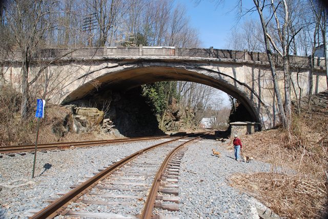
This is a unique concrete arch bridge. It has a skew, which is uncommon. But its abutments are the most unusual feature. It is built right into the natural rock outcroppings in the area. Because it is built around the rocks, and the uneven properties of natural rock formations, it does not have equal spring lines. Each end and indeed each side of the bridge has a different spring line. This can be clearly seen in the above photo on this page.
Information and Findings From Pennsylvania's Historic Bridge InventoryDiscussion of Bridge The skewed, single span, 70'-long reinforced concrete deck arch bridge is finished with concrete parapets that are plain on the roadway face and have panels on the fascia. The spandrel walls are plain. The bridge crosses the abandoned (tracks removed and now overgrown) right of way of the Mill Creek Railroad that was built starting in 1829 between Port Carbon and St. Clair and later beyond to access the coal mines. It was one of the many branch lines that crisscrossed the region, and it became part of the Reading system. The road it carries appears to have been developed as a modern route between Pottsville and Port Carbon. It is not a 19th century road. The bridge is a later example of its technology that was common by 1910. Neither the bridge nor its contexts are historically or technologically significant. Discussion of Surrounding Area The bridge carries a 2 lane road over an abandoned railroad right of way of the former Reading Railroad in a sparsely developed, forested setting on the south side of Port Carbon. The overgrown right of way (trackage removed) marks the limit of development in the town. It was the Mill Creek Railroad that went from Port Carbon to St. Clair, and it was part of the Reading system. Bridge Considered Historic By Survey: No |
![]()
![]()
![]()
Coordinates (Latitude, Longitude):
Search For Additional Bridge Listings:
Bridgehunter.com: View listed bridges within 0.5 miles (0.8 kilometers) of this bridge.
Bridgehunter.com: View listed bridges within 10 miles (16 kilometers) of this bridge.
Additional Maps:
Google Streetview (If Available)
GeoHack (Additional Links and Coordinates)
Apple Maps (Via DuckDuckGo Search)
Apple Maps (Apple devices only)
Android: Open Location In Your Map or GPS App
Flickr Gallery (Find Nearby Photos)
Wikimedia Commons (Find Nearby Photos)
Directions Via Sygic For Android
Directions Via Sygic For iOS and Android Dolphin Browser
USGS National Map (United States Only)
Historical USGS Topo Maps (United States Only)
Historic Aerials (United States Only)
CalTopo Maps (United States Only)

© Copyright 2003-2024, HistoricBridges.org. All Rights Reserved. Disclaimer: HistoricBridges.org is a volunteer group of private citizens. HistoricBridges.org is NOT a government agency, does not represent or work with any governmental agencies, nor is it in any way associated with any government agency or any non-profit organization. While we strive for accuracy in our factual content, HistoricBridges.org offers no guarantee of accuracy. Information is provided "as is" without warranty of any kind, either expressed or implied. Information could include technical inaccuracies or errors of omission. Opinions and commentary are the opinions of the respective HistoricBridges.org member who made them and do not necessarily represent the views of anyone else, including any outside photographers whose images may appear on the page in which the commentary appears. HistoricBridges.org does not bear any responsibility for any consequences resulting from the use of this or any other HistoricBridges.org information. Owners and users of bridges have the responsibility of correctly following all applicable laws, rules, and regulations, regardless of any HistoricBridges.org information.
![]()