

View Information About HSR Ratings
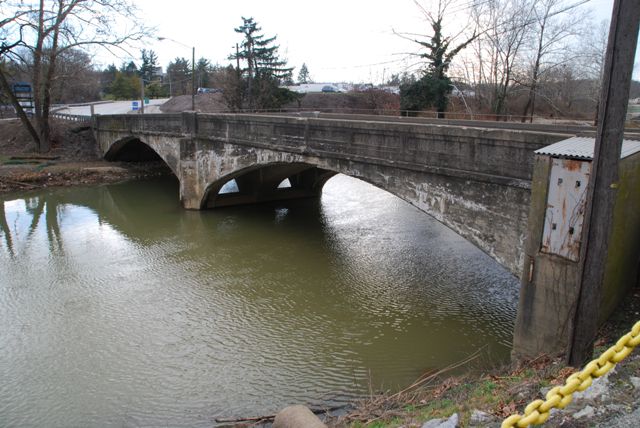
This bridge is a rare example of a ribbed concrete arch bridge. Despite what the Historic Bridge Inventory would suggest, very few examples remain in Pennsylvania. Thanks to PennDOT replacing this bridge, there will be one less example.
Information and Findings From Pennsylvania's Historic Bridge InventoryDiscussion of Bridge The 2 span, 135'-long, 3-ribbed reinforced concrete deck arch bridge built in 1923 has paneled concrete parapets and is supported on concrete abutments and pier. A cantilevered sidewalk with standard state highway department metal railing has been added to the upstream side (1958). Reinforced concrete arch bridges began appearing in numbers in Pennsylvania during the first decade of the 20th century, and by the early 1910s they were ubiquitous. The use of ribs is a savings of material but it requires extra formwork. An early example of a closed spandrel ribbed arch bridge is the 1907-1909 Mulberry St. viaduct in Harrisburg (BMS# 22 3012 0080 0233). By 1923, the construction of a ribbed closed spandrel arch bridge was not historically or technologically significant. The bridge is not distinguished by its setting or context. Discussion of Surrounding Area The bridge carries a 2 lane highway and a sidewalk over a stream in an industrial setting. To the southeast quadrant is a modern water treatment facility, and to the southwest quadrant is a parking lot. To the north is the Glatfelter Paper Co. with a large modern warehouse to the northeast quadrant, and an early 20th century brick building to the northwest quadrant. The bridge is not in the Spring Grove H.D. (NR-listed 5/25/84), which is separated from the bridge by the paper mill. The district encompasses the residential and commercial areas to the north of mill. The paper mill was not included in the district due to its scale and significant alterations. Bridge Considered Historic By Survey: No |
![]()
![]()
![]()
This historic bridge has been demolished. This map is shown for reference purposes only.
Coordinates (Latitude, Longitude):
Search For Additional Bridge Listings:
Bridgehunter.com: View listed bridges within 0.5 miles (0.8 kilometers) of this bridge.
Bridgehunter.com: View listed bridges within 10 miles (16 kilometers) of this bridge.
Additional Maps:
Google Streetview (If Available)
GeoHack (Additional Links and Coordinates)
Apple Maps (Via DuckDuckGo Search)
Apple Maps (Apple devices only)
Android: Open Location In Your Map or GPS App
Flickr Gallery (Find Nearby Photos)
Wikimedia Commons (Find Nearby Photos)
Directions Via Sygic For Android
Directions Via Sygic For iOS and Android Dolphin Browser
USGS National Map (United States Only)
Historical USGS Topo Maps (United States Only)
Historic Aerials (United States Only)
CalTopo Maps (United States Only)

© Copyright 2003-2024, HistoricBridges.org. All Rights Reserved. Disclaimer: HistoricBridges.org is a volunteer group of private citizens. HistoricBridges.org is NOT a government agency, does not represent or work with any governmental agencies, nor is it in any way associated with any government agency or any non-profit organization. While we strive for accuracy in our factual content, HistoricBridges.org offers no guarantee of accuracy. Information is provided "as is" without warranty of any kind, either expressed or implied. Information could include technical inaccuracies or errors of omission. Opinions and commentary are the opinions of the respective HistoricBridges.org member who made them and do not necessarily represent the views of anyone else, including any outside photographers whose images may appear on the page in which the commentary appears. HistoricBridges.org does not bear any responsibility for any consequences resulting from the use of this or any other HistoricBridges.org information. Owners and users of bridges have the responsibility of correctly following all applicable laws, rules, and regulations, regardless of any HistoricBridges.org information.
![]()