

View Information About HSR Ratings
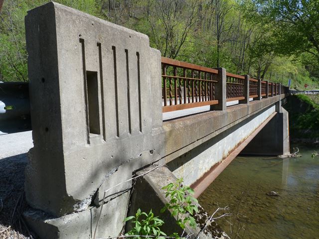
This bridge is an excellent example of a state standard steel stringer bridge from the mid 20th Century in Pennsylvania. Most importantly, the bridge retains the original ornamental railings with no modern railings added. The bridge is composed of two 60 foot spans. 60 foot spans are a common span length of steel stringer bridges from this period.
A short distance west of the bridge, there is a crumbling, abandoned wooden building that is a classic general store with its faded sign still legible on the top:
Information and Findings From Pennsylvania's Historic Bridge InventoryDiscussion of Bridge The 1956, skewed, 2 simple span, 126'-long steel stringer bridge with welded cross bracing diaphragms is supported on concrete abutments with wingwalls and a cutwater pier. Railings are standard design welded steel channel railings with concrete posts and vertical steel balusters. The bridge, although long, has no innovative or distinguishing details and is an example of the most common, 20th century bridge type in the state. Neither the bridge nor its setting/context are historically or technologically noteworthy. It is one of over 4341. Discussion of Surrounding Area The bridge carries a 2 lane road over a stream in a rural area of active farms west of Durbin. West of the bridge is a farmstead with a mid 20th century farmhouse and various outbuildings, but the modest, altered vernacular farmstead does not appear to be potentially eligible for the National Register. Bridge Considered Historic By Survey: No |
![]()
![]()
![]()
Coordinates (Latitude, Longitude):
Search For Additional Bridge Listings:
Bridgehunter.com: View listed bridges within 0.5 miles (0.8 kilometers) of this bridge.
Bridgehunter.com: View listed bridges within 10 miles (16 kilometers) of this bridge.
Additional Maps:
Google Streetview (If Available)
GeoHack (Additional Links and Coordinates)
Apple Maps (Via DuckDuckGo Search)
Apple Maps (Apple devices only)
Android: Open Location In Your Map or GPS App
Flickr Gallery (Find Nearby Photos)
Wikimedia Commons (Find Nearby Photos)
Directions Via Sygic For Android
Directions Via Sygic For iOS and Android Dolphin Browser
USGS National Map (United States Only)
Historical USGS Topo Maps (United States Only)
Historic Aerials (United States Only)
CalTopo Maps (United States Only)

© Copyright 2003-2024, HistoricBridges.org. All Rights Reserved. Disclaimer: HistoricBridges.org is a volunteer group of private citizens. HistoricBridges.org is NOT a government agency, does not represent or work with any governmental agencies, nor is it in any way associated with any government agency or any non-profit organization. While we strive for accuracy in our factual content, HistoricBridges.org offers no guarantee of accuracy. Information is provided "as is" without warranty of any kind, either expressed or implied. Information could include technical inaccuracies or errors of omission. Opinions and commentary are the opinions of the respective HistoricBridges.org member who made them and do not necessarily represent the views of anyone else, including any outside photographers whose images may appear on the page in which the commentary appears. HistoricBridges.org does not bear any responsibility for any consequences resulting from the use of this or any other HistoricBridges.org information. Owners and users of bridges have the responsibility of correctly following all applicable laws, rules, and regulations, regardless of any HistoricBridges.org information.
![]()