

View Information About HSR Ratings
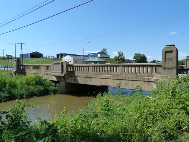
This bridge is a very special example of t-beam bridge in Pennsylvania. Designed by the state highway department, the bridge has a general superstructure design and even the general railing design is similar to many t-beams built in Pennsylvania. However, at the center of the bridge, the railings curve outward giving way to unique bays with a taller paneled wall, and on the northern side, where a sidewalk is present, this bay has a bench. The technical term for this arrangement is called an exedrae. Behind this bench on the wall a plaque that was a World War I veterans memorial plaque. This plaque has been removed. The bridge also has decorative posts/pylons at each end of the railing that once held lights. There apparently were other plaques on the posts as well, but have been stolen. These various aesthetic details make this bridge stand out as one of the most beautiful t-beam bridges in the state. Apparently one of the memorial plaques was not stolen and it has been removed by Waynesboro Borough and relocated to a town park memorial.
This bridge is, like so many historic bridges in Pennsylvania, slated for demolition and replacement.
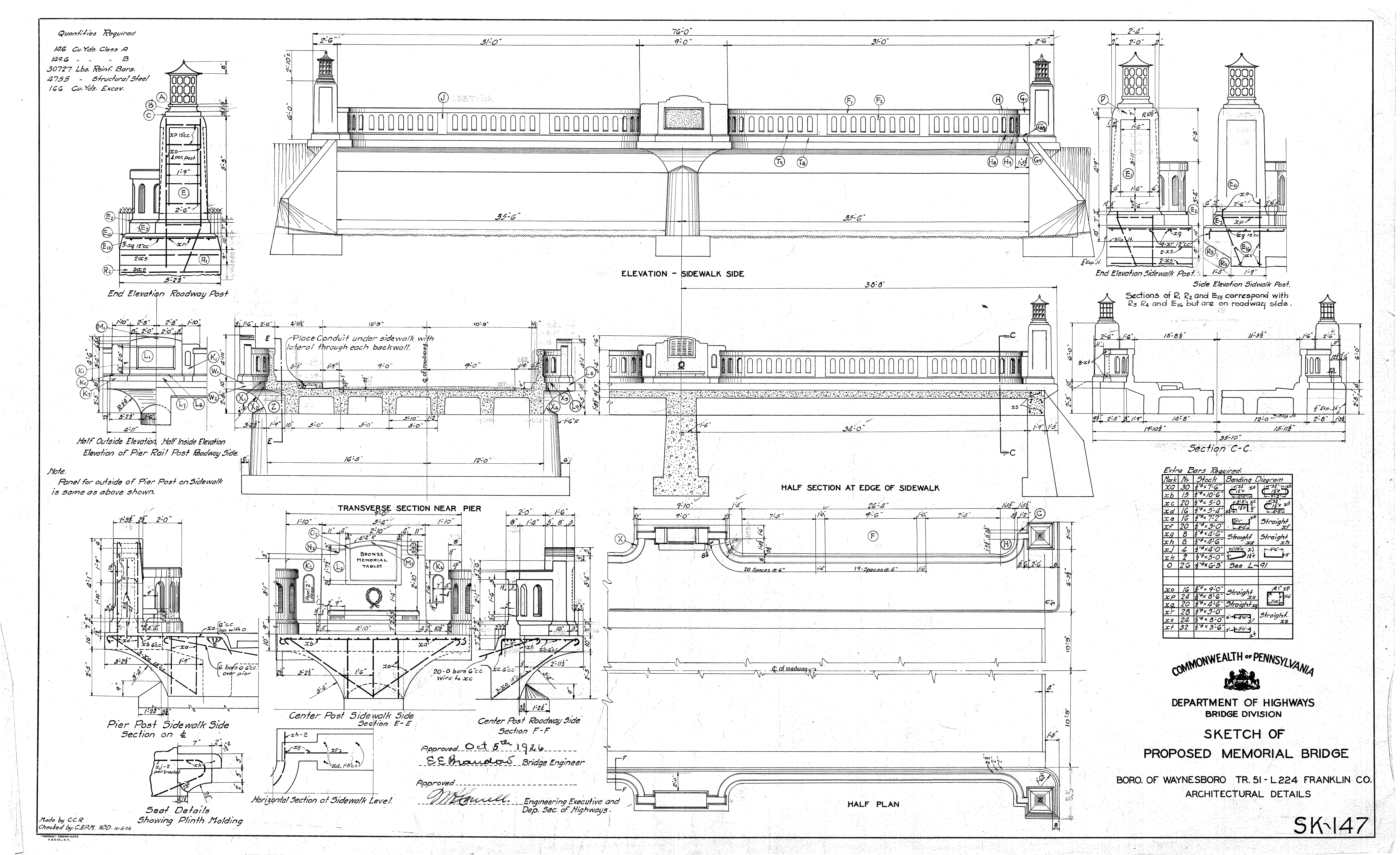
Information and Findings From Pennsylvania's Historic Bridge InventoryDiscussion of Bridge The 2-span, 76'-long, T beam bridge is supported on concrete abutments and cutwater pier. The bridge has standard concrete balustrades that have been architecturally embellished by the addition of paneled exedrae and paneled end pylons. The north side exedra has a memorial plaque to Waynesboro's World War I veterans. The bridge is technologically distinguished as an unusual architectonic example of the standard state highway department T beam bridge design. It dates from first-generation state highway improvements to an early state route and automobile tourist trail (SR 16/Buchanan Trail) and is the only such surviving architectonic highway bridge identified on the route. Discussion of Surrounding Area The bridge carries a 2 lane highway and 2 sidewalks over a stream that is the western boundary of Waynesboro. The bridge is in an area of predominately late-20th-century commercial development including car dealership and propane gas shop yard to the north and modern Moose and Elks lodges to the south. The bridge is approximately 1/2 mile west of downtown Waynesboro, which has been identified as an eligible historic district by PHMC (9/8/93). Several property lots to the east are late-19th to early 20th century residences and businesses but these have significant alterations. The bridge is more than eight blocks west of the boundary of the eligible district as delineated on the historic district map. The bridge is located on the Buchanan Trail, an early automobile tourist trail founded in the 1910s to promote tourism along a route from Baltimore to Pittsburgh by way of Waynesboro. It was named after James Buchanan, the only Pennsylvanian elected president, and passed through his birthplace near Cove Gap, Franklin County. Summary The 2-span, 76'-long, T beam bridge is supported on concrete abutments and cutwater pier The bridge has standard concrete balustrades that have been architecturally embellished by the addition of paneled exedrae and paneled end pylons. The north side exedra has a memorial plaque to Waynesboro's World War I veterans. The bridge is technologically distinguished as an unusual architectonic example of the standard state highway department T beam bridge design. It dates from first-generation state highway improvements to an early state route and automobile tourist trail (SR 16/Buchanan Trail) and is the only such surviving architectonic highway bridge identified on the route. Physical Description The 2-span, 76'-long, 30'-wide, reinforced concrete T beam bridge is supported on concrete abutments and cutwater pier. The bridge has standard concrete balustrades that have been architecturally embellished by the addition of paneled exedrae (pedestrian refuges with benches) at midspan and paneled end pylons. The panels have a pebble-dash textured finish, The exedrae are cantilevered from the bridge fascia and supported by brackets. The bench back of the north side exedra has a memorial plaque to Waynesboro's World War veterans, The bases of light standards remain on top of the end pylons but the standards and luminaires have been lost. Historical and Technological Significance The 1926 SR 16 (Buchanan Trail) over West Branch Antietam Creek bridge is technologically distinguished as an uncommonly architectonic T beam bridge dating from first-generation state highway improvements to a regionally and locally important state route (Criteria A and C), The bridge is noteworthy as an uncommon example of the standard design state highway department T beam bridge that was embellished with exedrae, end pylons, and luminaires to serve as a memorial to Waynesboro's World War I veterans. The bridge is located over the creek that is Waynesboro's western boundary. The T beam bridge, where the cast-in-place longitudinal beam and deck section are integrally connected, emerged as one of the most popular reinforced concrete bridge technologies in the state because of its overall economy of material and maintenance. In a T beam, the deck thickness and longitudinal beam size and spacing are proportioned to achieve a lighter, stronger, and more economical section than a slab bridge. Basically the same technology was used extensively by both the state highway department, which developed standard designs for T beam bridges, and the counties from the late 1910s through the 1950s, making T beams one of the most common bridge types in the state. There are over 2,300 T beam bridges in the state with the vast majority of them being simply supported. The earliest documented example dates to 1905, and about 30 from before 1916 remain. The state highway department built hundreds of nearly identical T beam bridges with standard concrete balustrades from the late 1910s through the 1950s. The SR 16 bridge is the most architectonic extant, first-generation, state highway department bridge on the Buchanan Trail. The trail, established in the 1910s by a group of local businessmen, was one of several automobile tourist trails that crossed the state and followed established state highway routes, that themselves had been built on top of old turnpikes. The Buchanan Trail paid honor to the only Pennsylvanian to be elected president, James Buchanan, and passed through his birthplace near Cove Gap, Franklin County. A state park was established on the site of the Buchanan Birthplace in 1911. The route offered a scenic alternative to travelers between Pittsburgh and Baltimore. Waynesboro was the largest town on this section of the route, which meandered over Tuscarora Mountain and Sideling Hill before linking with the Lincoln Highway at McConnelsburg. The Buchanan Trail was one of many tourist trails paved, widened, and realigned by the state highway department from the 1910s to the 1920s, and contributed to the increasing popularity of long-distance automobile tourism. The embellished SR 16 bridge was an uncommon concession by the state highway department to architectural aesthetics and local desire for a war memorial on the route. Boundary Description and Justification The bridge is recommended individually significant. The boundary is limited to the bridge's superstructure and substructure. Bridge Considered Historic By Survey: Yes |
![]()
![]()
![]()
This historic bridge has been demolished. This map is shown for reference purposes only.
Coordinates (Latitude, Longitude):
Search For Additional Bridge Listings:
Bridgehunter.com: View listed bridges within 0.5 miles (0.8 kilometers) of this bridge.
Bridgehunter.com: View listed bridges within 10 miles (16 kilometers) of this bridge.
Additional Maps:
Google Streetview (If Available)
GeoHack (Additional Links and Coordinates)
Apple Maps (Via DuckDuckGo Search)
Apple Maps (Apple devices only)
Android: Open Location In Your Map or GPS App
Flickr Gallery (Find Nearby Photos)
Wikimedia Commons (Find Nearby Photos)
Directions Via Sygic For Android
Directions Via Sygic For iOS and Android Dolphin Browser
USGS National Map (United States Only)
Historical USGS Topo Maps (United States Only)
Historic Aerials (United States Only)
CalTopo Maps (United States Only)

© Copyright 2003-2024, HistoricBridges.org. All Rights Reserved. Disclaimer: HistoricBridges.org is a volunteer group of private citizens. HistoricBridges.org is NOT a government agency, does not represent or work with any governmental agencies, nor is it in any way associated with any government agency or any non-profit organization. While we strive for accuracy in our factual content, HistoricBridges.org offers no guarantee of accuracy. Information is provided "as is" without warranty of any kind, either expressed or implied. Information could include technical inaccuracies or errors of omission. Opinions and commentary are the opinions of the respective HistoricBridges.org member who made them and do not necessarily represent the views of anyone else, including any outside photographers whose images may appear on the page in which the commentary appears. HistoricBridges.org does not bear any responsibility for any consequences resulting from the use of this or any other HistoricBridges.org information. Owners and users of bridges have the responsibility of correctly following all applicable laws, rules, and regulations, regardless of any HistoricBridges.org information.
![]()